The Construction of Voluntary Forest Carbon Projects in Papua New Guinea
A discussion paper published by the Development Policy Centre at the Australian National University
Logging companies mentioned in this document:
- VANIMO JAYA LIMITED
- MEKAR (PNG) LIMITED
- NIUGINI LUMBER MERCHANTS LTD.
- ASET MERIAH PNG LIMITED
- MILLENNIUM CORPORATION LIMITED
- VIVA SUCCESS LIMITED
- TUTUMAN DEVELOPMENT LTD
- JOINLAND MANAGEMENT (PNG) LIMITED
- TPT INVESTMENT LIMITED
- MILLIONPLUS CORPORATION LIMITED
- SENTAWAN (PNG) LIMITED
- FEFLO (PNG) LIMITED
- TARAIWARA PTY. LIMITED
Concessions mentioned in this document:
                                                                            Discussion Paper 105
                                                                                      NOVEMBER 2023
                                                                                 Series ISSN 2206-303X


                 THE CONSTRUCTION OF VOLUNTARY
                           FOREST CARBON PROJECTS
                               IN PAPUA NEW GUINEA

              Colin Filer, Andrea Babon, Bryant Allen and Michael Wood

            Abstract

            There is renewed interest in the capacity of private investors to use the revenues
            from the sale of carbon credits or offsets to reduce carbon dioxide emissions from
            the process of deforestation and forest degradation and thus help high -emission
            countries like Australia to meet their emission reduction targets. Papua New
            Guinea is one of the countries in which these voluntary forest carbon projects are
            being constructed, validated and certified in order for this market to be expanded.
            This paper examines some of these projects in detail in order to reveal some of the
            fundamental flaws in the way that their proponents represent what is happening
            in the areas where such investments are being proposed and approved. We aim to
            show what sorts of evidence would need to be presented in order for such projects
            to make a credible claim to achieve their stated goals. At the same time, we cast
            some doubt on the capacity of relevant government agencies and their
            development partners to ensure that projects of this kind will not simply benefit
            the companies that buy and sell carbon credits but also produce some real and
            lasting benefits for the rural communities whose members own the native forests
            that are being exploited in this peculiar way.


The Development Policy Centre is part of Crawford School of Public
Policy at The Australian National University. We undertake research
and promote discussion on Australian aid, Papua New Guinea and the
Pacific and global development policy.
The construction of voluntary forest carbon projects in Papua New Guinea

            Colin Filer, Andrea Babon, Bryant Allen and Michael Wood1

         Colin Filer is an Honorary Professor in the Crawford School of
         Public Policy at The Australian National University.
         Andrea Babon is an independent researcher and consultant.
         Bryant Allen in an Honorary Associate Professor in the
         Department of Pacific Affairs at The Australian National
         University.
         Michael Wood is an Adjunct Senior Lecturer in the College of Arts,
         Society & Education at James Cook University.

         Filer, C., Babon, A., Allen, B., & Wood, M. 2023, ‘The construction of voluntary
                    forest carbon projects in Papua New Guinea’, Development Policy
                    Centre Discussion Paper No. 105, Crawford School of Public Policy, The
                    Australian National University, Canberra.

         The Development Policy Centre is a research unit at the Crawford
         School of Public Policy, The Australian National University. The
         discussion paper series is intended to facilitate academic and
         policy discussion. Use and dissemination of this discussion paper
         is encouraged; however, reproduced copies may not be used for
         commercial purposes.

         The views expressed in discussion papers are those of the
         authors and should not be attributed to any organisation with
         which the authors might be affiliated.

           For more information on the Development Policy Centre, visit
                        devpolicy.crawford.anu.edu.au


1 This paper has taken account of insights and comments provided by a number of individuals,


including Pamela Avusi, Bazakie Baput, Paul Barker, Peter Dam, Linus Digim’rina, Gae Gowae,
Polly Hemming, Rodney Kameata, Jeff Kinch, Velma Kulukulu, Stephen Long, Mark Pilon, Lester
Seri and Ruth Turia. None of them should be held responsible for the overall argument or the
conclusions that have been reached.
Contents

Figures ..................................................................................................................................... 3

Tables ...................................................................................................................................... 4

1          Introduction ................................................................................................................ 5

2          New Ireland Hardwood Timber ............................................................................ 12

    2.1        Geographical scope of the project .......................................................................... 14

    2.2        The mysterious nature of NIHT’s rights ................................................................ 20

    2.3        The distribution of actual logging concessions ..................................................... 22

    2.4        Land groups and society ......................................................................................... 30

    2.5        Division of the spoils............................................................................................... 36

3          Forests for Certain: Forests for Life...................................................................... 38

    3.1        From eco-forestry to environmental services....................................................... 41

    3.2        Benefits from Environmental Services Trust ........................................................ 43

    3.3        Tavolo pilot project................................................................................................. 45

    3.4        Battle with NIHT ...................................................................................................... 52

4          Kanaka Management Services............................................................................... 55

    4.2        A lesson in cartography .......................................................................................... 60

    4.2.1 Topography .....................................................................................................................................................61

    4.2.2 Agriculture .......................................................................................................................................................65

    4.2.3 Logging ..............................................................................................................................................................67

                                                                                      1
    4.3        Ambition squared ................................................................................................... 69

    4.4        Misconceived and mysterious drivers ................................................................... 71

    4.4.1 Agriculture .......................................................................................................................................................73

    4.4.2 Logging ..............................................................................................................................................................76

    4.4.3 Mysteries...........................................................................................................................................................80

    4.5        Consultation and consent ....................................................................................... 81

    4.5.1 Limited consent in Oro Province............................................................................................................82

    4.5.2 Minimal consent elsewhere......................................................................................................................85

5          Mayur Resources or Renewables.......................................................................... 88

    5.1        Failure of the first FMA and the first REDD project .............................................. 90

    5.2        Fresh confusion in the corridors of power ............................................................ 94

    5.3        Reign of terror on the ground ................................................................................ 99

    5.4        The current legal stalemate.................................................................................. 101

6          Conclusion .............................................................................................................. 103

References ......................................................................................................................... 112


                                                                                      2
Figures

Figure 1: Territorial claims made by NIHT on behalf of landowners in the Konoagil LLG area .. 18

Figure 2: Volume of logs (in cubic metres) exported from New Ireland and East New Britain
provinces, 2000-2022 ............................................................................................................... 23

Figure 3: Current extent of logging concessions in the Konoagil LLG area ................................. 28

Figure 4: Round log exports (in cubic metres) from the Konoagil LLG area, 2016-2022 ........... 29

Figure 5: Round log exports from the ‘reference area’ in East New Britain, 2016-2022..................29

Figure 6: Relationship between the Mukus Melkoi SABL area and Tavolo REDD project area ... 48

Figure 7: Village locations in part of the Melkoi LLG area .......................................................... 52

Figure 8: Location of forest areas to be protected under KMS project proposals ....................... 57

Figure 9: Three polygons that constitute the Oro ‘project area’ ................................................. 58

Figure 10: Kira and Tamata LLG areas in Oro Province ............................................................. 61

Figure 11: Degrees of slope at the northern end of Oro Province............................................... 63

Figure 12: Landforms at the northern end of Oro Province ....................................................... 64

Figure 13: Indigenous agricultural systems in the KMS project area ......................................... 67

Figure 14: Commercial logging concessions in and around the KMS Oro project ....................... 69

Figure 15: Round log exports (in cubic metres) from two selective logging concessions ........... 77

Figure 16: A view of part of the KMS Oro project area southeast of Kira airstrip ....................... 79

Figure 17: Village locations in Kira LLG area .......................................................................................................64

Figure 18: Three forest areas in Western Province.................................................................... 92

Figure 19: Land group validation process in Kamiyame village, November 2019 ...................... 97

Figure 20: Round log exports (in cubic metres) from two existing concessions, 2016-2022 ...... 98

Figure 21: The SERACS team at Lake Campbell airstrip, July 2022 ...........................................102


                                                                          3
Tables
Table 1: Milestones in Papua New Guinea’s forest carbon policy process, 2008-2022 ................ 7

Table 2: PNG forest carbon projects submitted to Verra and the VCS by end of 2022 ................ 11

Table 3: Active logging concessions in Namatanai District, 2000-2022 ..................................... 24

Table 4: Applications for land group incorporation from Konoagil LLG area since 2013 ........... 31

Table 5: Applications for land group incorporation from Melkoi LLG area since 2013...................50

Table 6: Village locations and land claims of four ILGs in Oro Province..................................................82


                                                            4
    The construction of voluntary forest carbon projects in Papua New Guinea


1      Introduction

In February this year, the Australian Broadcasting Corporation aired a scathing
documentary about the practice of ‘carbon colonialism’ in Papua New Guinea (PNG)
(Long 2023). The Four Corners program took aim at three voluntary forest carbon
projects whose foreign promoters have been attempting to sell carbon credits to other
foreign companies in order to enable these other companies to ‘offset’ their own carbon
emissions by claiming to have reduced the emissions produced by the process of
deforestation and forest degradation in PNG. The authors of this discussion paper were
amongst the group of experts consulted in the making of this program. Once it had been
aired, we published a couple of blog posts elaborating on some of the points that could
not be covered at greater length in a TV documentary (Babon et al. 2023; Filer et al.
2023). In this paper we take the process of investigation a step further by providing a
lot more detail on the way that voluntary forest carbon projects have been constructed
by their proponents. We do not assume that all such projects are equally preposterous,
even if some of them are totally preposterous. Nor do we believe that these projects are
especially ‘colonial’ when compared with other forms of foreign investment in PNG’s
natural resources. But we do have to recognise that the process by which these projects
have been constructed in PNG is one national manifestation of a global process whereby
forest carbon credits or offsets are being manufactured and marketed as ‘nature -based’
solutions to the problem of climate change. And there is now a substantial body of
literature that questions whether companies and governments investing in this market
obtain anything more substantial than a hollow pretext for failing to reduce their own
greenhouse gas emissions (Romm 2023).

The forest carbon projects discussed in this paper are those that seek to reduce carbon
dioxide emissions from the clearance or degradation of PNG’s native forests by logging


                                           5

companies or local villagers. These are commonly called REDD projects in the
international literature. Although PNG’s forest policy framework recognises the
possibility of mitigating the effects of climate change by planting more trees (which is
part of the + in REDD+), carbon credits obtained in this way have not so far made their
way into the voluntary forest carbon market. The PNG government has been looking to
gain some material reward from the sequestration of native forest carbon since 2005,
when it was one of the founding members of the Coalition for Rainforest Nations. The
country’s representatives have therefore played an active role in debates about REDD
and REDD+ at successive conferences of the parties to the UN Framework Convention
on Climate Change (UNFCCC). The government also recognised that it would need to
develop a new set of institutions to regulate the forest carbon market when the
activities of foreign ‘carbon cowboys’ became the subject of a domestic and
international scandal in 2009 (Howes 2009; Melick 2010; Filer and Wood 2012; Babon
and Gowae 2013; Babon et al. 2014). Some of the key milestones in the policy process
through which these institutions have been established are listed in Table 1. An Office of
Climate Change and Development was initially established within the Department of
Environment and Conservation, and this became the Climate Change and Development
Authority (CCDA) with the passage of the Climate Change (Management) Act in 2015.
This is the agency through which the PNG government reports to the UNFCCC. It has a
broad mandate for activities relating to both mitigation and adaptation, but one of its
branches is specifically responsible for REDD policies, programs and projects. A variety
of overseas aid agencies have invested in the development of PNG’s regulatory
framework since 2010, but the scale of this investment has severely tested the
absorptive capacity of an organisation that has limited resources of its own.
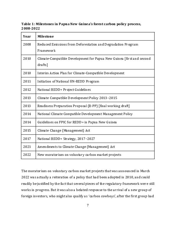
6
Table 1: Milestones in Papua New Guinea’s forest carbon policy process,
2008-2022

 Year      Milestone

 2008      Reduced Emissions from Deforestation and Degradation Program
           Framework

 2010      Climate-Compatible Development for Papua New Guinea [first and second
           drafts]

 2010      Interim Action Plan for Climate-Compatible Development

 2011      Initiation of National UN-REDD Program

 2012      National REDD+ Project Guidelines

 2013      Climate Compatible Development Policy 2013–2015

 2013      Readiness Preparation Proposal (R-PP) [final working draft]

 2014      National Climate Compatible Development Management Policy

 2014      Guidelines on FPIC for REDD+ in Papua New Guinea

 2015      Climate Change (Management) Act

 2017      National REDD+ Strategy, 2017–2027

 2021      Amendments to Climate Change (Management) Act

 2022      New moratorium on voluntary carbon market projects


The moratorium on voluntary carbon market projects that was announced in March
2022 was actually a reiteration of a policy that had been adopted in 2010, and could
readily be justified by the fact that several pieces of the regulatory framework were still
works in progress. But it was also a belated response to the arrival of a new group of
foreign investors, who might also qualify as ‘carbon cowboys’, after the first group had

                                            7
been persuaded to exit the country when they could not secure stamps of approval from
the government. The arrival of the newcomers had nothing to do with PNG’s half -built
regulatory framework. It was instead a result of the Paris Agreement that was signed by
the government parties to the UNFCCC in December 2015, and which came into effect in
November 2016. Articles 5 and 6 of the Paris Agreement constitute new milestones in
the global forest carbon policy process. Article 5 allows developing countries to re ceive
payments from developed countries for the avoidance of deforestation and forest
degradation, while Article 6 enables countries with high levels of greenhouse gas
emissions to ‘offset’ some of their contributions to climate change through the purchase
of carbon credits from countries that contain a surplus quantity of forest carbon. It is
Article 6 that has encouraged private companies to take a renewed interest in the
production and sale of forest carbon credits. A sizeable part of the market for new
carbon credits from PNG is located in Australia, and that is because Australia’s
‘nationally determined contribution’ to greenhouse gas emissions is very high, many
Australian companies are seeking to reduce their own carbon footprints, and the
Australian government has undertaken to help developing countries in the ‘Indo -Pacific
region’ to export carbon offsets to countries like Australia. The Four Corners program
concluded with a list of Australian companies that were in the market for carbon credits
from PNG, and the program echoed complaints that have been made about the way the
Australian government is using the carbon offset market to mask its likely failure to
meet its own emission reduction targets (Hemming et al. 2022).

The global trade in carbon credits or offsets currently entails a process whereby the
value of these commodities is certified by a third party, nominally independent of both
the buyers and the sellers. One of the most prominent performers of this mediating role
is an American non-profit organisation called Verra, which claims to administer ‘the
world’s leading standards for climate action and sustainable development’. The
standard most commonly applied to forest carbon projects is the one known as the
Verified Carbon Standard (VCS). Each metric tonne of carbon dioxide removed from the

                                            8
atmosphere by projects that are certified in accordance with this standard is described
by Verra as a Verified Carbon Unit (VCU). These commodities are sold at prices that vary
according to the nature of the project that produces them, the quality of the p rocess by
which they are supposedly produced, and the level of market demand. There are a
number of companies accredited by the VCS to validate or verify the compliance of the
production process with specific ‘methodologies’ applied to the calculation and
certification of the carbon credits that enter the market. Projects that seek to reduce
emissions from deforestation and forest degradation fall within a broader category of
‘agriculture, forest and other land use’ projects listed in the public registry ma intained
by Verra.
Aside from calculating the prospective volume of emission reductions, project
proponents and their consultants are also expected to show that their projects satisfy a
number of other criteria (Pan et al. 2022). First, they should demonstrate ‘additionality ’,
which means that revenue from the sale of carbon credits will be used to prevent the
generation of emissions that would otherwise have gone ahead in the place where the
investment is being made. Second, they should demonstrate a degree of ‘permanence’,
which means that the prevention of emissions in this location will last for a long period
of time. Third, they should ideally show that the prevention of emissions in this
particular location will not cause the activities producing the emissions to ‘leak’ from
one place to another. And finally, they should demonstrate that the investment made in
this location will be accompanied by ‘safeguards’ to ensure that it has no negative
impact on the livelihoods of local people, and might even produce what are sometimes
known as ‘co-benefits’. Compliance with national government regulations is sometimes
added as a fifth criterion, but is commonly overlooked unless the regulations deal
directly with one of the other four criteria.
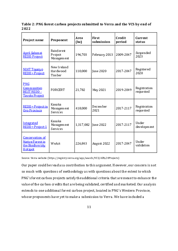
Table 2 lists all of the projects in PNG that are currently listed on Verra’s public registry
as ‘agriculture, forest and other land use’ projects. All of them have ‘REDD’ as the
9
primary activity to be pursued in the production of VCUs, although they vary in the
specific nature of the methodologies to be adopted in their quantification. The projects
are arranged in order of the date at which proposals were first submitted to Verra. Two
of these projects — the NIHT Topaiyo REDD+ Project and the REDD+ Project in Oro
Province — were featured in the Four Corners program. In this paper we examine both
of these projects in more detail, but we also examine the second project proposed by the
company called Kanaka Management Services and the Tavolo Project proposed by a
non-governmental organisation called FORCERT. We do not propose to examine the
April Salumei project in similar detail because this is a hangover from the earlier
invasion of PNG by ‘carbon cowboys’, and only survived the government’s resistance to
that invasion because it was granted a degree of official recognition (Filer 2015). No r do
we propose to investigate a very recent project proposal from the Australian company
called WeAct because we have very little information about the social and political
context of this proposal aside from what is contained in the first draft of the proposal
submitted to Verra (WeAct 2022). We shall return to a discussion of the prospect for old
projects to be revived, or new projects to be proposed, in the conclusion to this paper.

In January this year, The Guardian newspaper published an article summarising the
results of studies by scientists and journalists investigating the value of rainforest offset
credits with VCS certification issued by Verra (Greenfield 2023a). The key finding was
that 94 per cent of these things were ‘phantom credits’ that made no positive
contribution to the reduction of carbon dioxide emissions. The findings were promptly
challenged by Verra itself (Verra 2023). The arguments were primarily concerned with
the way that Verra’s ‘methodologies’ were being applied to the estimation of VCUs and
the extent to which claims of avoided deforestation could be supported by satellite
imagery. The arguments between the two sides made no specific mention of any of the
projects listed in Table 2.


                                             10
Table 2: PNG forest carbon projects submitted to Verra and the VCS by end of
2022

                                            Area          First              Credit      Current
 Project name           Proponent
                                            (ha)          submission         period      status

                        Rainforest
 April Salumei                                                                           Suspended
                        Project             196,703       February 2013 2009-2047
 REDD Project                                                                            2023
                        Management

                        New Ireland
 NIHT Topaiyo                                                                            Registered
                        Hardwood            110,000       June 2020          2017-2047
 REDD+ Project                                                                           2020
                        Timber

 PNG
 Communities                                                                             Registration
                        FORCERT             21,782        May 2021           2019-2049
 BEST REDD -                                                                             requested
 Tavolo Project

                  Kanaka
 REDD+ Project in                                         December                       Registration
                  Management                418,000                          2017-2117
 Oro Province                                             2021                           requested
                  Services

                        Kanaka
 Integrated                                                                              Under
                        Management          1,317,082 June 2022              2017-2117
 REDD+ Project 1                                                                         development
                        Services

 Conservation of
 Native Forest in                                                                        Under
                        WeAct               226,843       August 2022        2017-2047
 the Biodiversity                                                                        validation
 Hotspot

Source: Verra website (https://registry.verra.org/app/search/VCS/All%20Projects)

Our paper could be read as a contribution to this argument. However, our concern is not
so much with questions of methodology as with questions about the extent to which
PNG’s forest carbon projects satisfy the additional criteria that are meant to enhance the
value of the carbon credits that are being validated, certified and marketed. Our analysis
extends to one additional forest carbon project, located in PNG’s Western Province,
whose proponents have yet to make a submission to Verra. We have included a

                                                     11
discussion of this project because it was the third project featured in the Four Corners
program and because we know a good deal about the social and political context in
which it has been created.

We do not apply a standard template to our assessment of the project proposals under
discussion. Our aim is primarily to reveal the different sources of information that
would need to be used in the process of validation and certification if this were not to be
discounted as a ‘phantom process’. In the conclusion to this paper, we discuss the
lessons to be learned from a comparison of the proposals being made by the four
proponents and their consultants and then go on to discuss the factors that may
influence the future of the forest carbon policy process in PNG.

2      New Ireland Hardwood Timber

New Ireland Hardwood Timber (NIHT) is the name of an American company whose
local subsidiary, New Ireland Holdings Ltd, apparently entered into an agreement with a
landowner company called Topaiyo Holdings (or Holding) Ltd (THL) in 2014 with a
view to harvesting timber from an area of forest in New Ireland Province. NIHT is said
to have been registered with the PNG Forest Authority (PNGFA) as a ‘forest industry
participant’ in 2010, which is also the year in which THL obtained its certificate of
incorporation from the Investment Promotion Authority. According to a business plan
produced by NIHT in 2018, THL represents 22 landowning clans or land groups, but we
have not been able to access a copy of the company record in order to establish the
identity of its directors and shareholders so we cannot be sure of their provenance.
However, we do have a copy of the company record for the joint venture between NIHT
and THL (called ‘Top Development’), which reveals that none of the 11 directors, and
only two of the 17 shareholders, had a postal or residential address in New Ireland
Province, while eight of the directors and 11 of the shareholders appear to have been


                                            12

based in the neighbouring province of East New Britain. NIHT chairman Stephen
Strauss was the only foreign shareholder and director of the joint venture.

In 2018, Strauss produced a ‘business plan’ in which he stated that the joint venture had
abandoned its original intention to develop a conventional logging project and would
instead be looking to secure carbon credits from what is known in VCS jargon as a n
‘improved forest management’ project. To this end, NIHT engaged a Californian
company variously known as Ecological Carbon Offset Partners, ecoPartners or EP
Carbon to work out how much money could be made from the sale of such carbon
credits over a period of 30 years. They are said to have estimated that the gross revenue
would be 148 million US dollars ‘after taking out the payments to the clans, the cost of
the logging, milling, shipping and selling of the timber product’, while THL would make
a net profit of 74 million US dollars over the same period (Strauss 2018: 8). As a result,
ecoPartners was asked to issue a call for proposals from consulting companies
interested in developing a management plan for a logging operation that would comply
with the standards of the Forest Stewardship Council (ecoPartners 2018).

We do not know whether anyone answered this call, but by the time that EP Carbon
submitted the first draft of the project document to Verra in June 2020, it had turned
into what is known in VCS jargon as an ‘avoided unplanned deforestation and planned
degradation’ project (EP Carbon 2020a: 7). What this meant was that NIHT would now
seek to obtain carbon credits by avoiding the degradation entailed in any kind of logging
operation and by preventing local landowners or villagers from engaging in acts of
deforestation in their capacity as ‘secondary agents’ (ibid.: 32–3). In the revised draft of
the project document, which was submitted to Verra in September 2020, the change of
plan was justified as a means to benefit a larger number of people in New Ireland a nd
East New Britain provinces, even if it would reap a smaller financial reward for the
previous proponents of the logging operation. The change of plan was also cited as the


                                            13
reason why the joint venture had been dissolved in 2018 and THL had ceased to have
any role in the implementation of the project (EP Carbon 2020b: 16).

The revised draft was accepted by Verra as grounds for registration of the project at the
end of September 2020, with a ‘crediting period term’ that would last from 2017 to
2047, and an estimate that 55 million VCUs would be generated over that period.
Following the usual protocols, the first draft was made available for public comment in
the month following its submission (Verra 2020). NIHT then engaged a Spanish
company to conduct the validation and verification report (Aenor International 2020).
The main purpose of this audit was to validate the claims being made about the
projected volume of emission reductions, but the auditors also recorded NIHT’s
responses to the comments received during the period of public consultation and made
some attempt to check the views of ‘project stakeholders and beneficiaries’ by means of
conference calls. The coronavirus pandemic provided an excuse for their failure to visit
PNG at that juncture.

In what follows, we are less concerned with the methods and methodologies used to
estimate the volume of emission reductions, despite their obvious weakness, than with
the nature of the claims being made about the distribution of rights to the forest that
contains the carbon and the distribution of the benefits that might or might not arise
from keeping the carbon in the forest. While documents produced by NIHT and its
associated companies contain a variety of claims on both these scores, the
documentation is incomplete, and many of the claims do not make much sense.

2.1    Geographical scope of the project

The reason given for the transformation of a small-scale logging project into a large-
scale REDD project does not serve to resolve ambiguities that still surround the
question of scale. In its most ambitious form, the current project envisages the
protection of all the native forests in New Ireland and East New Britain provinces that

                                           14
have not yet been destroyed or degraded. But a further investigation of the claims made
by the proponent leads us to wonder whether the scope of the project is restricted to
New Ireland Province, or to one of the two districts within that province, or to o ne of the
five local-level government (LLG) areas within that district, or to an even smaller area.
At the core of the current REDD project is a fairly small area, which is said to consist of
10,443 hectares of forested land on the western coast of the Konoagil LLG area (EP
Carbon 2020b: 21). This is called the ‘first project activity instance’ (PAI) in the current
project description. It is said to belong to a single incorporated land group called
Kamlapar, whose executives are said to have transferred their timber harvesting rights
to NIHT by means of a ‘Contract for Sale of Hardwood Timber’ in Septembe r 2015. In
February 2020, when the proposed logging project had been transformed into a REDD
project, this agreement is said to have been replaced by a ‘Carbon Credit Contract’
between the same two parties (Aenor International 2020: 30). Members of the
Kamlapar land group appear to have been the only landowners who were interviewed
(remotely) by the project’s auditors before the project description was finalised.
It is not clear whether this small area of forest is the only forest area covered by a
document variously known as the ‘Konoagil Logging Plan’ or the ‘NIHT Timber Plan in
Konoagil’. We have not been able to access a copy of this document despite making
requests to NIHT and Verra. Perhaps it was a plan submitted in response to the call for
proposals issued by ecoPartners in 2018, which was then abandoned when NIHT opted
to pursue a REDD project instead of an improved forest management project. The call
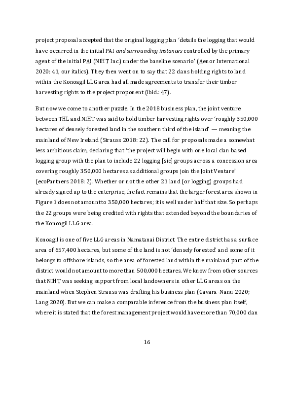
for proposals did include a map that shows a larger area of forest, within the Konoagil
LLG area, which is described as the ‘approximate area of the NIHT IFM project’ (see
Figure 1). If Kamlapar was only one of 22 clans or land groups whose interests were
represented by the landowner company (THL) that had entered into a joint venture
with NIHT, then we might infer that customary rights to this larger forest area were
shared between this larger number of customary groups. The auditors of the REDD
15
project proposal accepted that the original logging plan ‘details the logging that would
have occurred in the initial PAI and surrounding instances controlled by the primary
agent of the initial PAI (NIHT Inc.) under the baseline scenario’ (Aenor International
2020: 41, our italics). They then went on to say that 22 clans holding rights to land
within the Konoagil LLG area had all made agreements to transfer their timber
harvesting rights to the project proponent (ibid.: 47).

But now we come to another puzzle. In the 2018 business plan, the joint venture
between THL and NIHT was said to hold timber harvesting rights over ‘roughly 350,000
hectares of densely forested land in the southern third of the island’ — meaning the
mainland of New Ireland (Strauss 2018: 22). The call for proposals made a somewhat
less ambitious claim, declaring that ‘the project will begin with one local clan based
logging group with the plan to include 22 logging [sic] groups across a concession area
covering roughly 350,000 hectares as additional groups join the Joint Venture’
(ecoPartners 2018: 2). Whether or not the other 21 land (or logging) groups had
already signed up to the enterprise, the fact remains that the larger forest area shown in
Figure 1 does not amount to 350,000 hectares; it is well under half that size. So perhaps
the 22 groups were being credited with rights that extended beyond the boundaries of
the Konoagil LLG area.

Konoagil is one of five LLG areas in Namatanai District. The entire district has a surface
area of 657,400 hectares, but some of the land is not ‘densely forested’ and some of it
belongs to offshore islands, so the area of forested land within the mainland part of the
district would not amount to more than 500,000 hectares. We know from other sources
that NIHT was seeking support from local landowners in other LLG areas on the
mainland when Stephen Strauss was drafting his business plan (Gavara -Nanu 2020;
Lang 2020). But we can make a comparable inference from the business plan itself,
where it is stated that the forest management project would have more than 70,000 clan


                                            16
members as its ‘benefactors’ — presumably meaning its beneficiaries (Strauss 2018: 7,
16).

This claim had been modified by the time that the REDD project came to be audited.

       In the absence of accurate census data below the provincial level, the project
       proponent has been consulting with local clan members to establish more
       accurate numbers, and has so far identified more than 42,000 “stakeholders”
       through this process (Aenor International 2020: 25).

In 2011, the national census counted 11,024 people resident in the Konoagil LLG area.
This figure may not be entirely accurate, but it is not completely off the mark. Nor could
the population have grown by almost 400 per cent in less than a decade. In 2011, the
national census counted 92,633 people resident in the whole of Namatanai District,
some of whom were living on the offshore islands. It would therefore seem that NIHT
was claiming the support of a majority of the rural villagers or customary landowne rs in
the mainland part of the district, and not just those in the Konoagil LLG area, unless it
was also claiming the support of other villagers and landowners who were not even
living in this district.

According to the REDD project’s auditors, NIHT had ‘partnered with the traditional
landowners of New Ireland and East New Britain to put an end to deforestation initiated
by industrial logging in the region’, so ‘[t]he project area boundaries are the
administrative boundaries of the provinces of New Ireland and East New Britain’ (Aenor
International 2020: 7, 16). So additional landowners could have been recruited from
Kavieng District in New Ireland or from one of the four districts in East New Britain. The
latter might seem to be the more likely source, given the preponderance of East New
Britain residents amongst the shareholders and directors of the Top Development Joint
Venture. But their claim to ownership of land rights or timber harvesting rights in the
Konoagil LLG area would at best be tenuous.


                                            17
Figure 1: Territorial claims made by NIHT on behalf of landowners in the
Konoagil LLG area


Sources: ecoPartners 2018; EP Carbon 2020b.


                                              18
East New Britain has another role in the REDD project description, since it is home to
what is called the ‘reference area’. This consists of four forest conversion concessions,
covered by what the Forestry Act calls ‘Forest Clearing Authorities’, with a co mbined
area of approximately 106,000 hectares. But these are not part of the ‘concession area’
that is meant to be covered by the REDD project itself. Instead, they feature as examples
of the volume of carbon dioxide emissions that might be expected if the act of
deforestation were not to be avoided (Aenor International 2020: 67). The Verra website
tells us that the registered size of NIHT’s concession area is 110,000 hectares, which is
suspiciously similar to the size of the reference area. If the two have been confused, then
this is simply a mistake.

The most plausible way in which the REDD project could extend its coverage beyond the
boundaries of the Konoagil LLG area, and even Namatanai District, would be through a
process of gradual expansion or accumulation that the auditors describe as follows:

     At this time, it is not known how frequently PAIs will be added to the project or
     how large they will be since this will depend on adoption of the project by local
     communities. In order to provide an estimate of ex-ante project emissions, the
     project proponent has made the assumption that one or two additional PAIs will
     be added every year or every two years, beginning just with the current one
     (Kamlapar PAI) until the end of the 30 year project lifetime. (Aenor International
     2020: 45)

The final version of the project document provides no further detail on the likely targets
of this expansion plan. However, a couple of newspaper articles that were probably
based on press releases from NIHT suggest that the main target in East New Britain
consists of 75,000 hectares of forested land in the western part of Pomio District — a
long way from the reference area — that have been offered up by 14 groups of
customary landowners (Lima 2020, 2021).


                                            19
2.2    The mysterious nature of NIHT’s rights

For all the talk of NIHT acquiring timber harvesting rights from groups of customary
landowners, it is still unclear what legal mechanism has been used to effect these
transactions. The first draft of the REDD project document declares that ‘the [Namatanai
District] Development Authority and Minister of Mining of the Papua New Guinea
government’ approved the grant of a logging concession over the ‘first instance’ area in
2015 (EP Carbon 2020a: 14). One of the commentators on this draft pointed out that
district development authorities have no legal power to grant logging concessions, and
such a power is not even vested in the national forests minister, let alone the mining
minister (Verra 2020: 14). But no change was made to this peculiar statement in the
final version that passed the audit test and was accepted by Verra (EP Carbon 2020b:
16).

The only body that can legally grant logging concessions in PNG is the National Forest
Board, acting on advice from officers of the National Forest Service and with approval
from the relevant Provincial Forest Management Committee. There is no indication in
the records of the PNGFA that any large-scale logging concession had been granted to
NIHT or any of its known associates by 2018. The only type of concession that might
have been granted to the Kamlapar land group or another corporate body would have
been the one known as a Timber Authority (TA). Sections 87–89 of the Forestry Act
state that this type of concession may be issued for the clearance of small areas of native
forest for road construction or agricultural development, or else for small-scale timber
harvesting operations where the annual harvest does not exceed 5,000 cubic metres
and all the timber is used for local consumption. The PNGFA does not publish any
systematic record of the number of TAs that have been issued, the area that they cover,
or even their location within each province (Filer 2022: 12).


                                            20
This takes us back to the mystery surrounding the ‘Konoagil Logging Plan’. This plan is
said to justify the assertion that ‘the Kamlapar PAI would have been logged over a
period of two years’ if it were not for the implementation of the REDD project (Aenor
International 2020: 36). It is also said to have prescribed a timber harvest from 9,000
hectares of forest each year in the area over which the ‘clans of Konoagil’ had
transferred their logging rights to NIHT or its local subsidiary (EP Carbon 2020b: 80).
The reference to more than one clan might be taken to mean that the logging operation
would extend beyond the forest area claimed by the Kamlapar land group by the end of
the second year, but how much further would it go, and how many TAs would be
required for the operation to continue for 30 years? To these questions we simply have
no answers.

The mystery only deepens when we consider the advice that the Solicitor General
provided to the PNGFA in 2016, to the effect that REDD projects could not be authorised
under the terms of the Forestry Act once the Climate Change (Management) Act had
been passed in 2015, since this second piece of legislation vested this power in the
CCDA (GPNG 2016). If NIHT had indeed managed to accumulate a number of TAs by
2018, it might have been in a position to argue that the REDD project could be covered
by what is called a ‘climate change related project agreement’ in Sections 90–91 of the
Climate Change Act. And it does seem that the REDD project has secured some sort of
endorsement from the CCDA (Philip 2022). This is somewhat problematic, because
CCDA officials had not yet finalised the regulations that should apply to such projects
when NIHT’s project proposal was validated (Lang 2023). But what is more problematic
is NIHT’s capacity to show that its project is actually making any difference to the rate of
deforestation and forest degradation in the areas where it claims to have secured the
support of local landowners.


                                            21
2.3      The distribution of actual logging concessions

The final version of the REDD project document states that ‘[t]here has been no
industrial logging within the Kamlapar PAI within the past 10 years’ and ‘there are no
logging export records from within this area’ (EP Carbon 2020b: 50). This might have
been the case in 2020. However, other project documents make much broader claims
about the absence of commercial logging operations. According to the 2018 business
plan:

        New Ireland has experienced relatively little anthropogenic impacts in its
        southern half. A 500-ha area near the southwestern shore was impacted by a
        rustic timber operation for 20 years until terminating in 1996. A small palm oil
        operation exists in the south, but is limited by the steep topography. (Strauss
        2018: 28)

The 2018 call for proposals went a step further, claiming that ‘[t] he island of New
Ireland remains widely untouched by anthropogenic impacts’ (ecoPartners 2018: 2).
The final version of the REDD project document reverted to a claim that ‘[t]he island of
New Ireland has had limited commercial [log] harvests in the past 20 years’, and that
was given as the reason why the reference area had been located in the province of East
New Britain (EP Carbon 2020b: 63).

These broader claims are demonstrably false. Figure 2 compares the volume of round
log exports from the two provinces since the turn of the millennium. It is true that East
New Britain has had roughly twice the total volume of exports over this recent period —
about 10 million cubic metres compared to the 5 million exported from New Ireland.
But the volumes were almost identical in 2019, the year before Verra put its sta mp of
approval on the REDD project. And we must also be mindful of the fact that East New
Britain has a considerably larger surface area — 15,274 km2 as compared to New


                                             22
Ireland’s 9,557 km2 — so the overall intensity of this particular form of ‘anthropogenic
impact’ has been much the same across both provinces.
Figure 2: Volume of logs (in cubic metres) exported from New Ireland and East
New Britain provinces, 2000-2022
900000
800000
700000
600000
500000
400000
300000
200000
100000
0
New Ireland East New Britain
Source: SGS Annual Reports.
If we limit our attention to Namatanai District, in the ‘southern half’ of New Ireland
Province, we can see that eight different companies have been exporting logs from
concessions that, between them, cover more than half of the mainland part of that
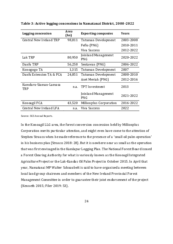
district at various points in time during the period since 2000 (Table 3). None of these
companies or their concessions rates a single mention in any of the documents
produced by NIHT or its consultants. It seems they have been operating in a parallel
universe.
23
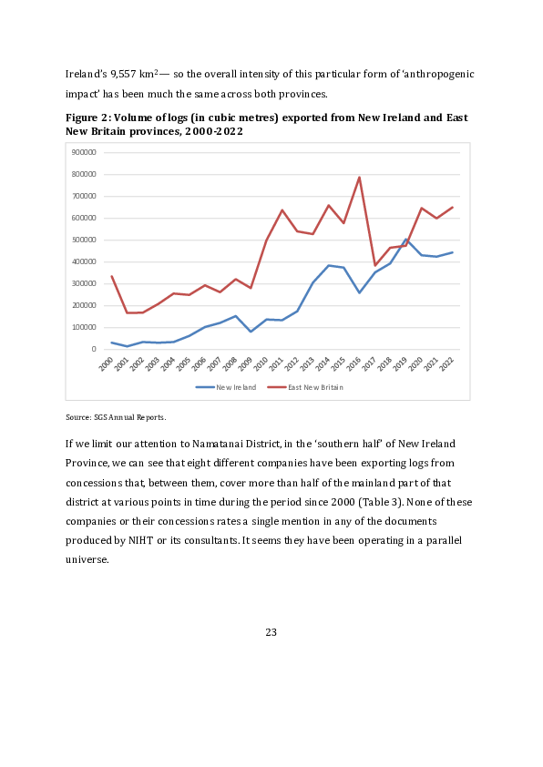
Table 3: Active logging concessions in Namatanai District, 2000 -2022

                              Area
 Logging concession                       Exporting companies       Years
                              (ha)
 Central New Ireland TRP       98,811 Tutuman Development           2003-2008
                                      Feflo (PNG)                   2010-2011
                                      Viva Success                  2012-2022
                                      Joinland Management
 Lak TRP                       80,950                               2020-2022
                                      PNG
 Danfu TRP                     56,258 Sentawan (PNG)                2006-2022
 Konogogo TA                    1,315 Tutuman Development           2007
 Danfu Extension TA & FCA      24,851 Tutuman Development           2008-2010
                                      Aset Meriah (PNG)             2012-2016
 Kamdaru-Siaman-Lamasa
                                     n.a. TPT Investment            2013
 TRP
                                      Joinland Management
                                                                    2021-2022
                                      PNG
 Konoagil FCA                  43,520 Millionplus Corporation       2016-2022
 Central New Ireland LFA             n.a. Viva Success              2022

Source: SGS Annual Reports.


In the Konoagil LLG area, the forest conversion concession held by Millionplus
Corporation merits particular attention, and might even have come to the attention of
Stephen Strauss when he made reference to the presence of a ‘small oil palm operation’
in his business plan (Strauss 2018: 28). But it is nowhere near as small as the operation
that was first envisaged in the Kamlapar Logging Plan. The National Forest Board issued
a Forest Clearing Authority for what is variously known as the Konoagil Integrated
Agriculture Project or the Lak-Kandas Oil Palm Project in October 2015. In April that
year, Namatanai MP Walter Schnaubelt is said to have organised a meeting between
local land group chairmen and members of the New Ireland Provincial Forest
Management Committee in order to guarantee their joint endorsement of the project
(Kenneth 2015; Filer 2019: 53).


                                            24
It is hard to believe that Stephen Strauss would not have noticed that this was going on
while he was negotiating his own deal with Topaiyo Holdings Ltd. Schnaubelt does not
seem to have wavered in his support for the oil palm scheme, but seems instead to have
used its progress as part of his successful campaigns for re-election to the national
parliament in the elections of 2017 and 2022. It therefore seems reasonable to infer that
the project is supported by a substantial number of the landowners and vote rs in his
electorate. Schnaubelt is another character who rates no mention in any of the
documents produced by NIHT or its consultants.

Given his position as MP, and then as national forests minister in 2021, it is likely that
Schnaubelt also endorsed the reactivation of selective logging concessions in two forest
areas where local landowners had agreed to transfer their timber harvesting rights to
the former Department of Forests by means of a ‘timber rights purchase’ (TRP)
agreement before the current Forestry Act came into effect in 1992. The Lak TRP
agreement was signed in 1989, and the Lak concession was originally granted to a
company called Niugini Lumber Merchants, a subsidiary of Rimbunan Hijau, which
exported logs from the area between 1993 and 1999. The concession now known as
Kamdaru-Siaman-Lamasa is based on a TRP agreement that dates back to 1973. Like the
Lak agreement, this one lasted for 20 years, so it expired before the government began
to record the volume of logs exported from each concession.

By 1996, when the government produced its first National Forest Plan, the Kamdaru -
Huru and Lamassa forest areas were designated as ‘potential areas for future
development’, which might be taken to indicate that little if any logging had actually
taken place under the terms of the original TRP agreement. Given that both TRP
agreements have expired, there are serious doubts about the legality of decisions to
grant new logging concessions in the absence of new agreements between the local
landowners and the PNGFA (Filer 2022: 56–7). Nevertheless, there are numerous
examples of such decisions being made by the National Forest Board, so the cases


                                            25
observed in the Konoagil LLG area are not exceptional. A company called TPT
Investment was exporting logs from the Kamdaru-Siaman-Lamassa concession in 2013,
but this concession and the Lak concession are both now in the hands of a company
called Joinland Management (PNG) Ltd. This company is closely related to Millionplus
Corporation, developer of the Lak-Kandas Oil Palm Project (Act Now and Jubilee
Australia 2022).

Figure 3 shows as much as we currently know about the extent of these current logging
concessions. The areas slated for conversion to oil palm are derived from a Powerpoint
slide produced by the project proponents, and are assumed to lie within the boundar ies
of the forest conversion concession that they obtained from the National Forest Board.
The PNGFA has not seen fit to divulge what it knows about the physical boundaries of
such concessions. The boundaries of the concessions currently held by Joinland a re
probably the same as the boundaries of the forest areas shown in the 1996 National
Forest Plan. There is no obvious explanation for what appears to be a substantial degree
of overlap between the concessions held by Joinland and the one held by Millionplus
Corporation, and we are not aware of any other examples of such an overlap between
different types of concession in any other part of PNG.

If we compare Figure 3 with the previous Figure 1, it should be obvious that there is
also a substantial degree of overlap between one or more of these actual concessions
and the more or less ambitious territorial claims that have been made by NIHT. Leavin g
aside the more ambitious claim made in the 2018 call for proposals, the recent Four
Corners program has suggested that one logging company has already made incursions
into the Kamlapar ‘first instance’ area (Long 2023). If that is the case, the most like ly
culprit would be Joinland Management in its capacity as holder of the Kamdaru -Siaman-
Lamasa concession. If that is a legal concession, there is no particular reason to think
that the company has been guilty of any additional illegality by logging beyond the
concession boundaries.


                                             26
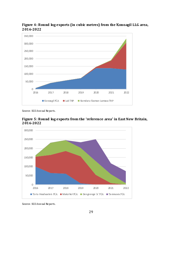
Now if we add up the volumes of logs that have been exported from the three
concessions that are currently active in the Konagil LLG area, we can see that there has
been a very substantial increase in the total volume since 2016 (Figure 4). Compare this
with the volumes exported from the four forest conversions concessions in the
reference area in East New Britain Province (Figure 5). There we see an increase
followed by a decline. That is not surprising. Once an area of forest has been cleared in
preparation for the planting of cash crops, whether or not the cash crops are actually
planted, there will be no more forest left to log. The harvest of logs from the Konoagil
Integrated Agriculture Project is also starting to fall, and will probably fall still fur ther in
years to come. But the parallel increase in the volume exported from the two selective
logging concessions in the Konoagil LLG area should be a cause for some concern to
anyone investing in the carbon credits produced by NIHT because the loggers ar e surely
making a substantial addition to the volume of emissions.


                                               27
Figure 3: Current extent of logging concessions in the Konoagil LLG area


Sources: PNG Forest Authority and Konoagil oil palm scheme proposal.


                                                      28
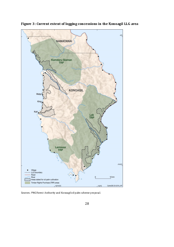
Figure 4: Round log exports (in cubic metres) from the Konoagil LLG area,
2016-2022
 350,000

 300,000

 250,000

 200,000

 150,000

 100,000

  50,000

       0
        2016        2017         2018           2019         2020      2021        2022

                  Konoagil FCA     Lak TRP       Kamdaru-Siaman-Lamasa TRP


Source: SGS Annual Reports.


Figure 5: Round log exports from the ‘reference area’ in East New Britain,
2016-2022
 300,000


 250,000


 200,000


 150,000


 100,000


  50,000


       0
        2016        2017         2018           2019       2020        2021       2022

        Toriu Headwaters FCA     Makolkol FCA      Dengnenge 'A' FCA   Taraiwara FCA


Source: SGS Annual Reports.


                                                        29
2.4 Land groups and society
According to the final version of the REDD project document, the Kamlapar
incorporated land group (ILG), the putative owner of the PAI that bears its name, was
the only ILG in the Konoagil LLG area that was already ‘officially enrolled’ in the project.
However, 12 other ILGs in the LLG area are said to have been ‘committed’ to the project
by 2020. These were named as the Boi Boi Marit, Kamrai Labei, Koroi Boi Boi, Koroir
Kabiawai, Leo, Marnai, Sor, Silbat, Tokboi, Bongian, Limut, and Mongon groups (EP
Carbon 2020b: 8–9). All are said to have entered into carbon credit agreements with
NIHT (ibid.: 32).
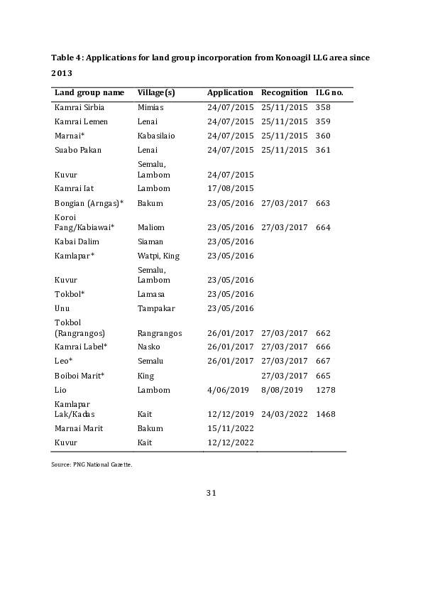
According to PNG’s National Gazette, a total of 17 land groups based in the Konoagil LLG
area made applications for incorporation in the three years between 2015 and 2017.
The eight whose names are marked with an asterisk in Table 4 would seem to be
amongst the 13 groups, including the Kamlapar group, whose executives are said to
have signed up to the REDD project. The National Gazette is not a completely reliable
source of information about the number of applications that have been made or the
number of groups that have been successful in obtaining certificates of recognition
(Filer 2019: 18–19). The Boiboi Marit group exemplifies one of the anomalies that can
be detected in the official record, because the National Gazette contains a recognition
notice that was not preceded by a notice of application. It is therefore possible that one
or more of the seven groups whose application notice was not followed by a recognition
notice, including the Kamlapar group, did in fact get to be registered as an ILG by the
Lands Department. It should also be noted that some of the village names specified in
application or recognition notices do not match the names of any census units or village
council wards recorded in the national census.
30
Table 4: Applications for land group incorporation from Konoagil LLG area since
2013

 Land group name                Village(s)    Application Recognition ILG no.
 Kamrai Sirbia                  Mimias        24/07/2015 25/11/2015 358
 Kamrai Lemen                   Lenai         24/07/2015 25/11/2015 359
 Marnai*                        Kabasilaio    24/07/2015 25/11/2015 360
 Suabo Pakan                    Lenai         24/07/2015 25/11/2015 361
                                Semalu,
 Kuvur                          Lambom        24/07/2015
 Kamrai Iat                     Lambom        17/08/2015
 Bongian (Arngas)*              Bakum         23/05/2016 27/03/2017 663
 Koroi
 Fang/Kabiawai*                 Maliom        23/05/2016 27/03/2017 664
 Kabai Dalim                    Siaman        23/05/2016
 Kamlapar*                      Watpi, King   23/05/2016
                                Semalu,
 Kuvur                          Lambom        23/05/2016
 Tokbol*                        Lamasa        23/05/2016
 Unu                            Tampakar      23/05/2016
 Tokbol
 (Rangrangos)                   Rangrangos    26/01/2017 27/03/2017 662
 Kamrai Label*                  Nasko         26/01/2017 27/03/2017 666
 Leo*                           Semalu        26/01/2017 27/03/2017 667
 Boiboi Marit*                  King                       27/03/2017 665
 Lio                            Lambom        4/06/2019    8/08/2019   1278
 Kamlapar
 Lak/Kadas                      Kait          12/12/2019 24/03/2022 1468
 Marnai Marit                   Bakum         15/11/2022
 Kuvur                          Kait          12/12/2022

Source: PNG National Gazette.


                                              31
The groups listed in Table 4 are the only groups from the Konoagil LLG area that are
known to have applied for incorporation or been registered as ILGs since the beginning
of 2013. This means that they are the only groups that might have had the legal capacity
to enter into agreements with third parties under the terms o f the amended version of
the Land Groups Incorporation Act that came into effect in 2012. We know that 22
groups from the Konoagil LLG area made applications for incorporation under the
original (1974) version of this law between 1995 and 2010, and that th eir applications
were almost certainly successful. It is conceivable, though rather unlikely, that these are
the 22 groups that were supposedly represented by THL when it was registered in 2010
(Strauss 2018: 22). Fifteen of these groups applied for incorporation over the course of
two months in 1995, probably with the aid of forestry officials who were aiming to
establish a new selective logging concession under the provisions of the 1991 Forestry
Act (Filer 2019: 52). That concession never eventuated. We have evidence that a group
by the name of Kamlapar was incorporated in 2006, but we have not been able to find
the corresponding application notice in the National Gazette. When the new legislation
came into effect, all existing land groups were required to reincorporate themselves
under stricter conditions, otherwise their certificates of incorporation would be
cancelled.

Some of the groups that applied (or reapplied) for incorporation between 2015 and
2017 may well have done so in order to signal their support for the oil palm scheme. In
2016, Walter Schnaubelt announced that a process of land group incorporation for
landowners who supported the scheme was already under way but had yet to be
completed, while dissident landowners reportedly complained to the forests minister
that the process of incorporation had been ‘done in haste and without the involvement
of the landowners’ (Kenneth 2016; Nalu 2016; Filer 2019: 53). The current Forestry Act
does not actually require that land groups be incorporated in order for landowners to
give their consent to the grant of a Forest Clearing Authority; they can do so by means of
a ‘public hearing’ organised by government officials (Filer 2019: 46). On the other hand,

                                            32
the group executives who reportedly signed carbon credit agreements with NIHT may
also have signalled their support for the oil palm scheme at some point in time. That
would be consistent with the behaviour of some landowners in the Lak forest area who
were prepared to hedge their bets when presented with an opportunity to cancel the
1989 TRP agreement and opt instead to support a government-sponsored forest
conservation project in the early 1990s (McCallum and Sekhran 1997).

We still have to wonder why it was that seven of the groups that applied (or reapplied)
for incorporation between 2015 and 2017, including the Kamlapar group, had failed to
secure a recognition notice in the National Gazette by the end of 2018. If this was not an
oversight on the part of the Lands Department, then it might have been due to
provisions in the current legislation that enable local landowners to object to an
application on the grounds that a group does not actually own the land to which it
makes a claim by means of a ‘sketch map’ (Filer 2019: 12). We have not sighted a copy
of the sketch map submitted by the Kamlapar group in 2016, but Table 4 shows that a
notice of application from another group by the name of Kamlapar Lak/Kadas was
gazetted in December 2019, and that this group was registered in April 2022. The
members of this group were said to reside in Kait village, whereas the members of the
Kamlapar group that apparently failed in its bid for incorporation were said to reside in
the villages of Watpi and King, which are located to the north of Kait and within the
boundaries of the PAI claimed by NIHT (see Figure 1). The second Kamlapar group is
known to have challenged the legitimacy of the first Kamlapar group, and is said to be
opposed to the NIHT project (Peter Dam, personal communication, March 2023).

According to the NIHT business plan produced in 2018, the landowner company THL
was held responsible for the process of land group incorporation and the registration of
land titles (Strauss 2018: 12). As we have seen, THL was given no role at all in the
subsequent design and implementation of the REDD project (EP Carbon 2020b: 16).
And we know very little of the actions that NIHT staff might have taken to ensure the


                                           33
integrity of the land groups with which it was making agreements between 2018 and
2020. What can be inferred from notices published in the National Gazette is that none
of the registered ILGs in the Konoagil LLG area had got to the point of submitting an
application for the registration of their land titles under the amended version of the
Land Registration Act before the end of 2018, nor are we aware of any such applications
being made since then. So we are still dealing with a situation in which land grou ps have
nothing more than sketch maps to indicate the extent of their claims to ownership of
specific blocks of land, and most of the groups that hold customary land rights in the
LLG area have not even got around to producing sketch maps because they have yet to
apply for incorporation.

All this must lead us to question NIHT’s claim that members of the Kamlapar clan based
in Watpi and King villages, whose application for incorporation was apparently
unsuccessful, really do own the whole of the area that NIHT calls its first PAI. To
understand why this claim is implausible, we need to grasp a basic feature of social
organisation in this part of PNG, which is that villages typically contain the members of
several clans, while a single clan, such as Kamlapar, Bongian, Kamrai or Tokbol, typica lly
has members dispersed across several villages. The clan section that consists of clan
members who live together in one village may have primary or secondary rights to land
within the territorial boundaries of that village. There may be some villages in which
primary land rights are vested in a single clan section, but in most villages there are
several clan sections with primary rights (Albert 1989). There is nothing in the
legislation to prevent the landowning clan sections in one village from banding together
to form a single ILG, nor is there anything to prevent the sections of one clan who live in
different villages from doing so. However, the second of these moves is problematic
because the land holdings of the different clan sections would rarely b e contiguous. The
architect of the current legislation clearly expected that each clan section in a rural


                                            34
village, or possibly in a council ward, or in what had traditionally been an autonomous
political community or ‘tribe’, would form a separate ILG (Filer 2019: 10–11).2

If, for the sake of argument, we assume that there are an average of four clan sections
with primary land rights in each of the 17 council wards or each of the 42 rural village
census units in the Konoagil LLG area, then the number of ILGs that might be fo rmed in
accordance with this expectation could be anything between 68 and 168. The process of
land group incorporation that has actually taken place to date has clearly been messy,
riddled with disputes, and very far from settling the question of which gro ups have
primary rights to which blocks of land. The story of the Kamlapar clan’s dealing with
NIHT is just one aspect of this messy process. It appears that the Kamlapar clan
members in Kait village, who have succeeded in incorporating the Kamlapar Lak/Ka das
ILG, wrote a letter to CCDA officials in 2021 in which they disowned the actions of the
Kamlapar clan members in King and Watpi villages who had done a deal with NIHT in
2015 but then failed to get their own ILG registered (Lang 2021). King and Kait ar e two


2 To this we might add a further layer of complexity once we allow for the fact that people also argue

about which clans are actually ‘sub-clans’ of other clans. These are essentially arguments about which
clan names take precedence over other clan names. So the members or leaders of clan X may argue that
clan Y is not really a separate clan but is only a sub-clan or junior branch of clan X, while the member or
leaders of clan Y may argue that X and Y have equivalent status, with separate memberships, or mi ght
even argue that X is really a part of Y. The members of the different sections of a clan who agree that it is
indeed a clan in its own right, with its own name, may also argue with each other about which section is
the most senior section, and that type of argument will often turn on the questi on of where the clan
originated and how its members subsequently came to be dispersed between different villages. The point
about all such disputes is that they are almost impossible to resolve, especially when they involve
members of different villages or council wards. If anything, the disputes are only intensified when there is
any prospect of landowners receiving monetary benefits from any commercial exploitation of their
customary land.


                                                     35
of the three villages in the council ward called Kait, while Watpi is one of the three
villages in the council ward called Watpi. We do not know whether there are Kamlapar
clan members with primary land rights in all six of the villages in these two council
wards, or how many Kamlapar clan members are represented by the ILG that has been
registered. But it is very unlikely that any collection of Kamlapar clan members holds
exclusive primary rights to all the land in NIHT’s ‘first instance’ area.

2.5     Division of the spoils

According to a newspaper report that was most likely based on a press release from
NIHT, a total of 6 million kina generated from the company’s sale of carbon credits was
paid out to more than 47,000 residents of Konoagil LLG area in July 2021, and this to tal
comprised payments of 200 kina to each household containing children over the age of
15 (Mathew 2021).3 Individuals from the ‘first instance’ area who were interviewed for
the Four Corners program complained that this was the only payment that landowners
had so far received from NIHT, and were clearly puzzled that the money was spread so
far beyond the ‘first instance’ area that they believed to be the true source of the carbon
credits (Long 2023).

Something is clearly amiss with the figures quoted in the newspaper article. It might be
true that 30,000 out of 47,000 residents of some (unspecified) area were in households
containing children over 15 years of age, but it is very unlikely that there wer e more
than 20,000 people resident in the Konoagil LLG area in 2021, and more likely that the
number was closer to 15,000. So perhaps the 6 million kina was shared amongst the
residents of a much larger area. Many of the households within the Konoagil LLG area
would also have been in receipt of timber royalties from one or other of the three large -


3 One PNG kina is currently worth about 27 US cents.


                                                  36
scale logging concessions. The royalties payable to landowners currently average 23
kina per cubic metre (Filer 2022: 14). The Konoagil landowners should thus have
received a total of 19.5 million kina from these three concessions over the seven years
between 2016 and 2022. We cannot be sure that they actually did receive this amount
of money. If they did, then households on the end of both financial benefit streams
might count themselves lucky, but their adult members would also notice that one was
worth a good deal more than the other.

The question of benefit distribution between NIHT, landowners and government
agencies does not receive much attention in the REDD project documentation. In the
final version of the project document, it is stated that ‘[t]he project plans to offer
communities 56% of the profits of the project ... which will go directly to clan members’
(EP Carbon 2020b: 24). There are promises to provide a variety of other material
benefits to local communities, but no cash values are attached to them. In 2021, a
memorandum of agreement was reportedly signed between NIHT and CCDA whereby
NIHT would pay a 15 per cent tax on its net profits, with 7 per cent going to CCDA and 8
per cent to the New Ireland Provincial Government (Ellison 2022; Philip 2022). That
would leave NIHT with 29 per cent of the proceeds. We do not know whether these two
arms of government actually received their tax revenues when the landowners received
their first payment.

According to the 2018 NIHT business plan, a body called the Topaiyo Landowners
Association was to be responsible for ‘the distribution of the profits and proceeds from
the timber and carbon projects’ (Strauss 2018: 12). This body seems to have been
dissolved when the timber project was abandoned and THL was excluded from
development of the REDD project. According to the REDD project auditors:

     Clan leadership voted that every man, woman, and child should receive their fair
     share of the distribution of funds and this is written into the design of the benefit
     distribution mechanism. In addition, each clan that joins the project must have five

                                             37
     committees to help manage the distribution and project implementation. (Aenor
     International 2020: 18)

The idea that a group with a few dozen members, including children, would be able to
sustain the management of five different committees seems rather far -fetched. Yet there
is no indication that they played any role in deciding which households should rece ive a
payment of 200 kina in 2021.

The committee structure rates no mention in the template that NIHT has been using to
forge its carbon credit agreements with local clans or ILGs. What is interesting about
this template is that it authorises NIHT to withhold the sum of 15,000 kina from the first
payment due to each group and to withhold all payments until the clan has actually
secured its registration as an ILG. The 15,000 kina is divided between two portions —
5,000 kina that is to be paid to a designated firm of surveyors and 10,000 kina that NIHT
will use to pay Lands Department officials and other people to secure the certificate of
registration. As we have seen, a professional survey is not required for the process of
incorporation, only for the registration of group titles under the amended version of the
Land Registration Act. Nor is it clear why the process of incorporation should cost so
much. In any case, from the numbers already cited, it is hardly possible to believe that
all of the 30,000 households that supposedly got 200 kina in 2021 were members of
land groups that had already been incorporated under the current legislation. We
cannot think of any way to square this circle.

3      Forests for Certain: Forests for Life

FORCERT is a non-governmental organisation (NGO), registered as a not-for-profit
company, which is a longstanding member of PNG’s ‘conservation policy community’
(Filer 2005). The acronym is currently an abbreviation of ‘Forests for Certain: Forests
for Life’. It was previously an abbreviation of ‘Forest Management & Product


                                           38
Certification Service’.4 FORCERT drafted its proposal for what is known as the ‘PNG
Communities BEST REDD – Tavolo Project’ in May 2021 (FORCERT 2021), but it did not
make an appearance on the Verra website until August 2022. 5 The Tavolo project was
still ‘under development’ at the end of 2022 because it was still undergoing a final
process of validation and verification. We understand that a new project document
(Version 1.3) was submitted to Verra in May 2023, but most of our references in this
paper will be to the earlier version submitted in 2021. There is no substantial difference
in the way that the two versions deal with the questions in which we are interested.

The project document was drafted with technical assistance from another NGO called
Face the Future, which is based in the Netherlands (https://facethefuture.com/). A
Dutch electricity company called Greenchoice provided 200,000 euros in start-up
funding, which enabled FORCERT to meet some of the costs of the validation process
and trial its model for sharing benefits with local landowners. Greenchoice also made a
commitment to purchase 1.2 million VCUs to be generated by the project in its first four
years of operation (Peter Dam, personal communication, August 2023). The project
itself is distinguished from the others discussed in this paper by its relatively small
scale. It covers an area of less than 22,000 hectares in the Melkoi LLG area in Pomio
District in East New Britain Province. It is clearly meant to be a ‘community-based’
project, and Tavolo is presented as the name of the community in which it is based. The


4 In both cases, one might expect the abbreviation to be ForCert rather than FORCERT, but the latter is the

title preferred by its owners and other members of the policy community, and is also the name of the
entity registered with the Investment Promotion Authority.

5 No comments were made on the proposal at that juncture,    despite the proponent’s attempts to solicit
such comments from a range of national and international stakeholders.


                                                    39
relationship between the community and the project proponent is described at the
beginning of the project document.

     In order to protect their forests and forest resources, whilst still obtain[ing] a
     revenue source, the community first approached FORCERT in 2007 to enquire into
     the possibility of carrying out community based small scale logging operations
     under the FSC [Forest Stewardship Council] Group Certification Service Network
     that FORCERT then managed. To become a member of this Service Network, the
     community organized itself first into the Tavolo Business Group, with the idea of
     using their FSC certified portable sawmilling operation to generate income and
     employment for the community, allowing them to protect their forest. When it
     became clear that these benefits alone would not be sufficient to guarantee this
     protection, the community started work with FORCERT to trial Payments for
     Environmental Services as additional income generation under the PNG
     Communities Benefits from Environmental Services Trust (PNG Communities
     BEST). The community then decided to organize themselves [sic] under the Tavolo
     Community Conservation Association ..... and committed itself to sustainably
     manage their land, carrying out FSC certified small scale reduced impact logging
     on a dedicated part of their forest, while the remainder of their forest is put under
     conservation. (FORCERT 2021: 4)

According to the project document, the ‘crediting period’ should be 30 years and should
start in 2019, since that is the year in which the various partners signed up to the
project, and also the year in which another group of actors signed up to agreements that
threatened a process of deforestation in the designated project area. The original
project document estimates a reduction of just over 6 million VCUs over three decades if
this threat is countered, but the nature of the forest conversion project posing the threat
means that the bulk of these saving will be made in the first decade (FORCERT 2021: 6 –


                                            40
10). The most recent project document has taken about 1 million VCUs out of the
equation.

The Tavolo project is obviously meant to be a pilot project in a program that will enable
a number of different communities to receive payments for environmental services
(PES) from the PNG Communities Benefits from Environmental Services Trust (BEST).
Before we examine the specific rationale for the Tavolo project, we therefore need to
understand how FORCERT has come to establish this broader institutional framework
as an alternative to the practice of community forestry, and how the sale of forest
carbon credits figures in this framework. This in turn will provide an indication of the
way that FORCERT aims to develop a national PES scheme with multiple partners.

3.1    From eco-forestry to environmental services

FORCERT was registered as a company in 2003 and started operation in the following
year. Its original shareholders were three other NGOs — Greenpeace, the Worldwide
Fund for Nature and the Centre for Environmental Law and Community Rights
(CELCOR) — but most of the shares are now vested in a number of local communities.
In the decade preceding its establishment, overseas aid agencies and international NGOs
had invested in a number of eco-forestry or community forestry projects in PNG as part
of a larger program of action to protect the country’s native forests from the destructive
effects of large-scale commercial logging operations. Some of these investments or
experiments appeared to be successful in the short term, but it was not so clear that this
kind of community enterprise would be sustainable in the longer term without the
continuation of external support (Chatterton et al. 2000; van Helden and Schneemann
2000; WWF and World Bank 2000; Hunt 2002). The establishment of FORCERT was
meant to address the problem of sustainability by joining all these small-scale projects
together in a single network that would enable the quality of their output to be jointly
certified according to the standards set by the Forest Stewardship Council. This process


                                           41
of ‘group certification’ was meant to expand the domestic and overseas markets for the
timber produced by the small-scale sawmills distributed across multiple communities
and raise the prices paid to the producers. FORCERT itself was meant to escape the ne ed
for external subsidies through the collection of membership fees from the local
sawmillers and the four ‘central marketing units’ to which they were supposed to sell
their timber (Scheyvens 2006).

The subsequent history of the organisation and the network is documented in a series
of external evaluation reports commissioned by the shareholders or managers, which
can be downloaded from the FORCERT website (https://forcertpng.org/resources/). By
2010 it was evident that the Group Certification Service Network had failed to achieve
its economic and financial objectives, and FORCERT was struggling to reconcile its role
as a business enterprise or marketing organisation with its role as an agent of
community development or environmental protection (Scheyvens 2009; Rosenbaum et
al. 2010). By 2013 the continuing contraction of the network and the fall in the volume
of certified timber sales underlined the need for a major change in the organisation’s
orientation (Ericho et al. 2013). The idea that FORCERT could help loca l communities to
obtain payments for environmental services was already being touted in 2010
(Rosenbaum et al. 2010). The pursuit of forest carbon credits through community-based
REDD or REDD+ projects was seen as one of the avenues through which such bene fits
might be secured, but this was also seen as a somewhat risky venture because of the
scandal that had erupted around the invasion of PNG by foreign ‘carbon cowboys’ in
2009 (Melick 2010; Dam 2011). On the other hand, the establishment of PNG’s UN -
REDD program in 2011 was seen as an opportunity for FORCERT to engage with the
PNGFA and what was then the Office of Climate Change and Development to create a
new regulatory framework in which community-based REDD projects, as well as eco-
forestry projects, could get more support from the national government (Ericho et al.
2013).


                                           42
The change in what the name FORCERT was taken to stand for seems to have taken
place when a new strategic plan was adopted in 2015, following a lengthy process of
stakeholder consultation (Dore et al. 2019). The central focus of the organisation now
shifted towards the production of community sustainable land use plans. Although it
was recognised that these plans could generate payments for environmental services,
especially for the management or protection of native forests, there was still some
doubt about the feasibility of producing and distributing revenues from these sources.
While the plans could still have a small business component that did not need to involve
the production of timber with portable sawmills; it could just as well involve the
production of cash crops like cocoa. In that respect, FORCERT began to resemble a
number of other national NGOs that were already in the business of forest conservation
and sustainable community development. But FORCERT also took on a more proactive
role in the national forest policy process through its engagement with relevant
government agencies as well as with a small selection of local communities. That is how
it came to play a significant role amongst the NGOs that agreed to the formation of a
new peak body called the PNG Environmental Alliance that was registered in 2022 and
continues to advocate for progressive forest policy reform and robust regulation of
forest carbon projects at a national level.

3.2    Benefits from Environmental Services Trust

The idea of establishing a national trust fund to distribute landowner benefits from
forest conservation projects has been around for some time, and has now found its way
into the national policy framework. However, questions about the management of such
an institution are still hotly debated because different actors do not trust each other to
manage it for the real benefit of the landowners rather than themselves. FORCERT
established the BEST version when it began to conduct its experiments on the
distribution of PES in 2018 (Avusi and Dam 2020), and the choice of acronym is meant
to signal its superiority. The CCDA made a commitment to support the ‘proposed PES


                                              43
system for PNG’ through a memorandum of agreement with FORCERT that was signed
in January 2018, a copy of which is appended to the Tavolo project document. The
FORCERT website states that the trust is meant ‘to become a long-term independently
managed fund to support community conservation efforts in PNG through generating
additional income from environmental services’. The sale of VCUs is described as the
most likely source of income in the short term.

The Tavolo project document says that discussions with members of the Tavolo
community and two other ‘trial communities’ have led to the decision to allocate 20 per
cent of revenues from the sale of carbon credits to the ‘supporting organisations’
(FORCERT and Face the Future), 70 per cent to local communities, and 10 per cent to
different levels of government (FORCERT 2021: 12). 6 The community share is to be
divided between seven ‘baskets’ containing different public goods and services. Cash
payments to individuals or families are ruled out because of the risk that money will be
misappropriated or unfairly distributed (ibid.: 13). Although this model of benefit
distribution is described as the outcome of negotiations with particular communities,
FORCERT seems to have adopted elements of this model before the trust was
established (Ericho et al. 2013).

One of the key features of the model is what has sometimes been described as a ‘step -
wise approach’ to the problem of deciding which communities deserve support from an
NGO that has limited human and financial resources to invest in partnerships that may
or may not yield positive outcomes over a period of several years. The origins of this
approach can be traced back to an eco-forestry program that was funded by the
European Union during the 1990s (Salafsky 1997). FORCERT has since adopted a


6 If the government were to raise the rate of tax then this would reduce the share allocated to the

communities.


                                                    44
‘community selection matrix’ with a long list of criteria by which to assess the likelihood
of a positive or sustainable outcome from any particular partnership, but the latest of its
external evaluations considered that the selection process was still somewhat arbitrary
(Dore et al. 2019: 10). The Tavolo project document states that communities granted
admission to the BEST scheme ‘will have undertaken a High Conservation Values
assessment, and have started their participatory community sustainable land us e
planning process, which will result in an agreed sustainable land use plan and
community conservation laws’ (FORCERT 2021: 38). The distribution of material
rewards derived from the sale of carbon or biodiversity credits is not to be discussed
until these steps have been completed.

3.3     Tavolo pilot project

The Tavolo REDD project has a strong claim to additionality because of the threat posed
by the Kakuna-Lote Agro Forestry & Reforestation Plantation Development Project. The
proponent of this agro-forestry project is a landowner company called Kakuna-Lote
Resource Development Ltd (KLRDL), which is said to have purchased a lease over
68,000 hectares of land in the Melkoi LLG area from another landowner company, Rera
Holdings Ltd, in 2019. The directors of KLRDL then made an agreement with a logging
company called Mekar (PNG) Ltd in order to obtain a Forest Clearing Authority (FCA). 7
According to the FCA project proposal, which was attached as an appendix to the REDD
project document, about 20,000 hectares of forest in the southern part of the lease area
would be cleared within a period of eight years and most of this land would then be
planted with a mixture of eucalyptus, cocoa and coffee (KLRDL and Mekar (PNG) Ltd


7 Mekar is a subsidiary of Vanimo Jaya, which operates a number of other logging concessions in various

parts of PNG.


                                                   45
2019). The project proposal was approved by the provincial authorities in December
2019, despite the objections of Tavolo community leaders.

The contest over plans to log this area of native forest has a long and convoluted history
that continues to cast a shadow over the current plans of different stakeholders. In
1996, some landowner representatives signed up to a Forest Management Agreement
(FMA) over what is known to forestry officials as the Mukus Tolo or Tolo Mukus forest
area.8 This enabled the National Forest Board to enter into a ‘project agreement’ that
should have led to the grant of a Timber Permit for a selective logging operation, but the
process of resource allocation ground to a halt. In 2000, a government inquiry found
that the resource acquisition process had been flawed because the landowner
representatives who signed the FMA only represented a minority of the landowners,
and that members of some coastal communities in the LLG area were actually opposed
to a large-scale logging operation (GPNG 2000).

In 2004, the former Pomio District MP Paul Tiensten engineered the design of a much
bigger agro-forestry project that would have encompassed the Mukus Tolo forest area
as well as a number of other forest areas that have since been cleared for oil palm
cultivation, but there was some confusion about which landowner companies
represented which groups of landowners (Filer 2011). In 2008, a Special Agricultural
and Business Lease (SABL) over what was now being called the Mukus Melkoi area was
issued to Rera Holdings, and that was the foundation on which an FCA was issued to a
logging company called Double Dynasty Lumber in 2010 (Gabriel et al. 2017). By that
time, leaders of the Tavolo community had already sought help from FORCERT and
CELCOR to block the proposed logging operation (Scheyvens 2009). The SABL was one


8 This name is derived from the names of the two rivers that constitute the eastern and western

boundaries of the forest area.


                                                   46
of several such leases that became the subject of a commission of inquiry in 2011, but
the commissioner investigating the Mukus Melkoi lease failed to complete the report of
his findings. As a result, the lease was not cancelled or revoked, which is why it could be
acquired by KLRDL in 2019. Figure 6 shows that the SABL covers most of the Tavolo
REDD project area, while the latter accounts for roughly 30 per cent of the area covered
by the SABL. The area covered by the new FCA substantially overlaps the Tavolo REDD
project area.

The Tavolo project document includes a map of the ‘land use plan’ that qualifies the
local community for inclusion in the BEST scheme (FORCERT 2021: 31). This map
dedicates about 15,000 out of the 22,000 hectares to conservation, including some
pockets with ‘high conservation value’. The remaining 7,000 hectares is mostly divided
between areas dedicated to food gardens, cash crops and eco -forestry, with some
allowance for part of it to be converted to one of these uses in future and part of it to be
set aside as a ‘disputed area’. The whole area covered by the land use plan is said to be
covered by a Conservation Deed that was signed in 2019 and witnessed by the
president of the Melkoi LLG.9 This agreement has been registered with the Office of the
State Solicitor (Peter Dam, personal communication, August 2023).


9 The proponents   were not able to get the project area officially recognised as a Community Conservation
Area under the terms of the Protected Areas Policy of 2014 because the Protected Areas Bill had not been
passed by the national parliament when the REDD project proposal was submitted to Verra. The
legislation has been delayed by arguments over control of the trust fund that is meant to facilitate
expansion of the protected area network (Filer 2022: 25).


                                                    47
Figure 6: Relationship between the Mukus Melkoi SABL area and Tavolo REDD
project area


Source: FORCERT 2021: 14

The community engaged in this agreement with FORCERT is not confined to the village
or the council ward to which the name Tavolo is applied in the national census. The
Tavolo Community Conservation Association (TCCA) is said to represent three
communities — Tavolo, Mukus and Lausus — whose locations are shown on the land
use plan, but the map also shows two other settlements called Simi and Tangolo within
the boundaries of the Tavolo project area. In the 2011 census, Tangolo is the name of a
community school in the Makmak council ward. Simi and Lausus villages count as wards
in their own right, while the Tavolo ward contains three villages — Tavolo, Mukus and
Eunga. The community represented by the TCCA consists of the Tavolo, Simi and Lausus
wards, but not the Makmak ward. The Tangolo community school features in the land
use plan because it is located on the border between the Simi and Makmak wards. The

                                          48
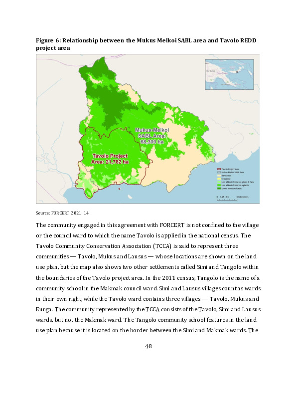
three wards represented in the TCCA had a combined population of 1,088 in the 2011
census.

To get a better sense of how the residents of the Melkoi LLG area might be divided in
their support for different projects, we have checked to see which villages have
produced applications for land group incorporation since 2013. Table 5 shows that 13
land groups have been incorporated, and these are distributed between seven villages.
Five of these villages are highlighted in red on a map showing the locations of the rural
villages whose residents are likely to have been involved in the agro -forestry project
proposal or the REDD project proposal (Figure 7). 10 As noted in our discussion of the
NIHT project proposal, the application and registration notices give no indication of the
reasons why land groups have been incorporated, but when a number of applications
are made on the same day, it is reasonable to assume that they are related to a single
project. The six applications lodged in May 2019 could therefore be related to the REDD
project proposal, even though some of the villages from which these applications were
derived are not located within the boundaries of the project area. However, ILGs have
no formal role in the constitution of the TCCA.


10 The names of the villages did not change between 2000 and 2011, and most of them would have stayed

in the same place.


                                                 49
Table 5: Applications for land group incorporation from Melkoi LLG area
since 2013
 Land group name                Village(s)   Application Recognition ILG no.
 Litupupuna                     Ulpuna       19/05/2016 31/03/2016 528
 Rama                           Atu          23/05/2016 21/09/2016 527
 Awila                          Maso         23/09/2016 27/02/2017 639
 Kipolo                         Maso         23/09/2016 27/02/2017 640
 Chamoso                        Maso         30/08/2017 11/01/2018 1015
 Una                            Maso         30/08/2017 11/01/2018 1016
 Avila                          Uvol         20/05/2019 19/08/2019 1286
 Kaikaie Malel                  Uvol         20/05/2019 19/08/2019 1287
 Rama Simsim                    Tavolo       20/05/2019 19/08/2019 1288
 Sauthom                        Buruwe       20/05/2019 19/08/2019 1289
 Walwalpo                       Weipo        20/05/2019 19/08/2019 1290
 Una Lote                       Tavolo       20/05/2019 19/08/2019 1291
 Aluka Musenpo                  Uvol         17/10/2019 12/12/2019 1318

Source: PNG National Gazette.


What we do know is that the landowner company KLRDL claims the affiliation of five of
the ILGs listed in Table 5. One is the Litupupuna ILG based in the village of Ulpunai,
otherwise known as Hulpuna, in the northern part of the LLG area, which was
registered in March 2016. The other four are the Awila, Kipolo, Chamoso and Una ILGs,
all based in the coastal village of Maso, which were registered in February 2017 and
January 2018. None of these ILGs is registered as a shareholder in KLRDL. The company
record lodged with the Investment Promotion Authority shows that two individuals are
registered as the shareholders and six other individuals are registered as directors. As
we have already noted, there is no requirement in the Forestry Act for ILGs to be party
to an application for an FCA. Most of the 40 ILGs that supposedly consented to the
Mukus Tolo FMA in 1996, and most of the 34 that supposedly consented to the Mukus


                                             50
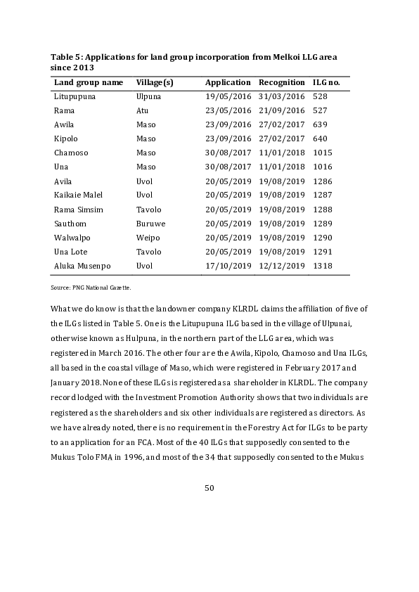
Melkoi SABL in 2008, have not been reincorporated under the amended version of the
Land Groups Incorporation Act, so they should not be able to consent to any new project
agreements.

The landowners supporting the REDD project are said to have raised a sum of K10,000
to pay for legal action to cancel the SABL (FORCERT 2021: 10). This has been
supplemented by the funding that FORCERT has secured from Greenchoice. The same
legal action seeks to cancel the FCA that was issued to KRLDL and its ‘development
partner’ in January 2022. At the end of 2022, the National Forest Board resolved to
impose a moratorium on the grant of FCAs pending an audit of the agroforestry projects
for which they had already been granted, but we do not know what steps have been
undertaken to audit the one that has been issued for the Kakuna -Lote agro-forestry
project.


                                          51
Figure 7: Village locations in part of the Melkoi LLG area


Source: PNG 2000 national census GIS.


3.4     Battle with NIHT

During the past three years, since NIHT’s project proposal was submitted to Verra,
FORCERT has been engaged in a struggle to challenge the validity of NIHT’s claim to
have the support of all the local landowners living in the vicinity of its ‘first project
activity instance’ in the Konoagil LLG area. That is because FORCERT has a partnership
with Kait village that dates back to 2007, and which has therefore been in effect for as
long as its engagement with the Tavolo community (Titus et al. 2007; Scheyvens 2009).


                                             52
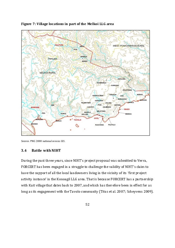
Like Tavolo, Kait is one of the ‘trial communities’ that were involved in development of
the BEST scheme for distributing the benefits of forest conservation. The Kait land use
plan, which dates from July 2018, is reproduced in FORCERT’s latest external evaluation
report (Dore et al. 2019: 12).11 In that report it was noted that FORCERT personnel had
made 13 visits to the village over the previous three years — more than to any other of
the organisation’s partner communities (ibid.: 19). The land use plan is also featured on
the FORCERT website, where ‘paramount chief’ Joel Tamanriu and ‘community leader’
Tom Oscar are pictured standing in front of a signboard to which the map has been
attached.12

As we have seen, the Kamlapar clan members in Kait village, who succeeded in
registering the Kamlapar Lak/Kadas ILG in 2022, have sought to disown the actions of
the Kamlapar clan members in King and Watpi villages who apparently signed up to the
NIHT project in 2015. Although this seems at first sight to be a contest between two
branches or sections of the Kamlapar clan, it is also a contest between the residents of
King and Kait villages, both of which belong to the Kait council ward, because the Kait
land use plan is limited to the territory of Kait village, and does not cover any part of the
‘first instance area’ assigned to the Kamlapar clan in the NIHT project proposal (see
Figure 1). Mr Tamanriu is widely recognised as the chief of the Kamlapar clan sections
distributed across several villages in the Konoagil LLG area. Unlike Mr Oscar, who is
listed as the treasurer of the newly formed ILG, Mr Tamanriu is not listed as a member


11 The area covered by the Kait land use plan largely overlaps an area slated for inclusion in the Konoagil

oil palm scheme (Figure 3), as well as the area included in NIHT’s ‘Konoagil logging plan’ (Figure 1), but
villagers engaged in the production of the land use plan do not seem to have been aware of this additional
act of alienation.

12 https://forcertpng.org/benefi ts-from-environmental -services-best-carbon-credits -projects/


                                                    53
of its executive body. However, he does appear as a member of the Kamalapar clan in
the court action that was launched in 2020 to prevent two of the clan’s members from
disposing of land within the territory of King village, and this action was clearly
intended to prevent the alienation of Kamlapar clan land to NIHT.

This dispute has still not been resolved, but has only been complicated by a sequence of
communications between staff of FORCERT, NIHT and the CCDA. The point at issue
appears to be the extent of the rights that the leaders of a clan section in one village can
exercise over land belonging to a section of the same clan resident in another village or
land occupied by sections of other clans resident in the same village. While NIHT has
made the mistake of thinking that all of the land within the territorial bo undaries of
King village belongs to the Kamalapar clan, FORCERT has not made the same mistake in
Kait village, where the land use plan is based on a recognition that land rights are
distributed between ten different clans (Peter Dam, personal communication , March
2023). When FORCERT was still an eco-forestry program, the registration of ILGs was
regarded one of the qualifications for membership of the Group Certification Service
Network (Scheyvens 2009). But the complexity of relationships between clan land
rights and village land rights in the Konoagil LLG area has been sufficient to dissuade
the new version of the organisation from basing the Kait land use plan on the
incorporation of all ten clans, including the Kamlapar clan, that have land rights within
the territory of this one village. FORCERT is now supporting the legal action that
Kamlapar clan representatives have taken against NIHT in the National Court (Peter
Dam, personal communication, August 2023).


                                            54
4       Kanaka Management Services

Kanaka Management Services (KMS) is a private company based in the city of Bengaluru
(formerly Bangalore) in the southern Indian state of Karnataka. 13 In 2022, an
organisation called Environmental Finance awarded the company a prize for being the
world’s best developer of REDD projects. The company’s own website boasts that it has
won ‘fifteen prestigious global awards since 2013 for consultancy and pro ject
development’ in the voluntary carbon market. The website makes no specific mention of
what KMS has been up to in PNG, but we rather doubt that its two adventures in that
country would merit the award of any prizes at all.

In December 2021, KMS produced a document called ‘REDD+ Project in Oro Province of
Papua New Guinea’. The project proposed in this document covers 418,000 hectares of
land — an area more than twice the size of London — which would then have made it
the second largest project to be proposed under Verra’s VCS framework. The proposal
envisages a program of avoided unplanned deforestation yielding annual reductions in
carbon dioxide emission of just over 8 million VCUs over a period of 100 years
beginning in 2017. This is four times the annual number of VCUs claimed by the NIHT
project.

In June 2022, KMS produced a second document called ‘Integrated REDD+ Project 1 in
Papua New Guinea’. The project proposed in this document is even more ambitious. It


13 The name Kanaka is derived from the Sanskrit word for gold. For people familiar with the history of

PNG it sounds like it might derive from the Tok Pisin word kanaka, which was applied to indentured
labourers, and the indigenous population more broadly, during the colonial period, and is still
occasionally used to designate backward or ignorant villagers. The coincidence is rather unfortunate, but
may also be rather ironic.


                                                    55
covers 1.3 million hectares of land — an area larger than the entire country of Vanuatu
— covering parts of four different provinces. This proposal envisages annual reductions
in carbon dioxide emission of just over 20 million VCUs over the same period. If
validated and verified, this would be by far the largest forest carbon project to date
under the VCS. Substantial parts of the first project document have be en copied and
pasted into the second one, with some adjustments made for the scale and locations o f
the larger project. The Four Corners team revealed the absurdity of the first project
proposal (Long 2023), but the second one is even more preposterous. Figure 8 shows
the location of the Oro project and the two project locations specified in the second
proposal.

We submitted a variety of critical comments on both project proposals when Verra
opened the respective windows of public consultation. Several criticisms of the Oro
project proposal are contained in a paper published by The Australia Institute
(Hemming and Babon 2022). Some of these criticisms were concerned with the way in
which KMS calculated the volumes of carbon stocks and emission reductions. In what
follows we are more concerned to document the company’s inability or unwillingness to
use existing data sources to develop a reasonably accurate portrait of PNG’s physical,
social and political landscape.


                                           56
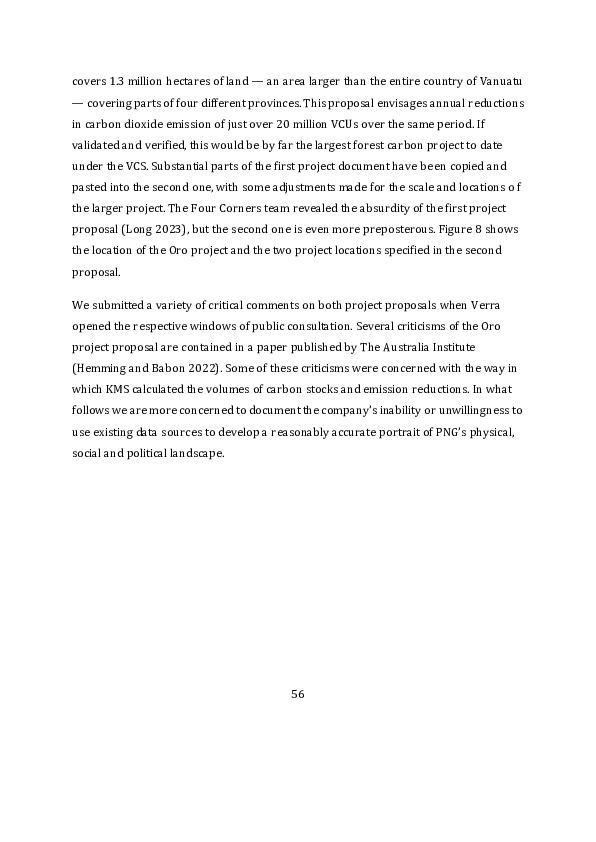
Figure 8: Location of forest areas to be protected under KMS project proposals


Sources: KMS 2021: 14; 2022: 15.


4.1     A fuzzy project boundary

The Oro project document included an initial ‘project location map’ with no features or
landmarks that would enable the exact location to be identified. This map simply
identified the boundaries of three polygons that were said to constitute the ‘project
area’ (see Figure 9). A separate KML file was uploaded to the Verra website which
provided more information about the location. This file was derived from a Google
Earth image, but several of the place names on this map do not accord with place names
in official government records. On this map the three polygons are bounded by red lines
and located within a larger polygon that is also bounded by a red line and therefore
seems to constitute the outer limit of a larger project area.


                                            57
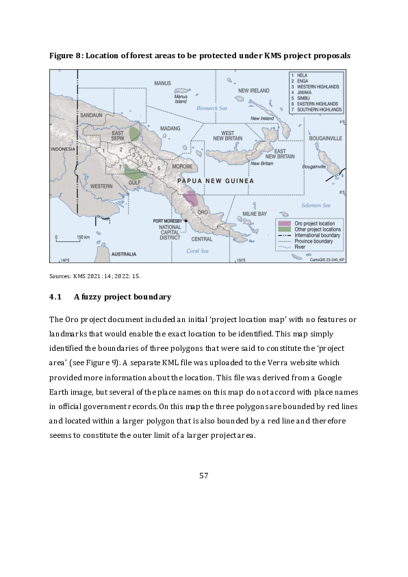
Figure 9: Three polygons that constitute the Oro ‘project area’


Source: KMS 2021: 14, 36.


In one part of the Oro project document, this outer boundary is represented as the
‘leakage belt’ (KMS 2021: 36). This appears to mean that the space within this belt that
does not fall within any of the three polygons will be the space in which the proces s of
deforestation and forest degradation is expected to continue. The distinction between
the three parts of the ‘project area’ and the outer limits of the ‘leakage belt’ is said to be
based on the assumption that forests within a certain distance of exis ting roads and
settlements are bound to continue leaking carbon dioxide.

Although the project document implies that the three polygons dedicated to forest
conservation contain the 418,000 hectares from which forest carbon credits will be
generated, a national newspaper article that is most likely based on a KMS press release
suggests that the three polygons contain 380,000 hectares of forest reserved for


                                             58
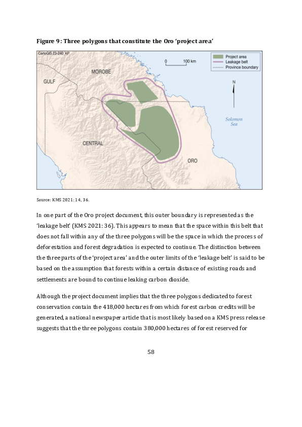
‘sustainable development’ while another 32,000 hectares have been allocated for
‘subsistence farming and agriculture’, which presumably counts as a form of leakage
(Anon. 2019a). That would leave another 6,000 hectares of ‘leakage’ still to be
accounted for. This might be the extent of a few small polygons within the leakage belt,
but not within the conservation polygons, that are represented in the project document
as ‘leakage management areas’, where there will be ‘activities to avoid deforestation’
(KMS 2021: 36). Since these small areas are excluded from the polygons that constitute
the ‘project area’ in Figure 9, it is not clear whether these activities are expected to be
successful.

The Google Earth image on which the boundaries of the conservation polygons and the
larger project area have been inscribed also shows the boundary between Oro Province
and Morobe Province to the north and Central Province to the west. Nowhere in the
project document is any reason given for the inclusion of parts of Morobe and Central
provinces in a project that is said to be located ‘in Oro Province’. Only one of the maps
contained within the project document shows the provincial boundary, and that is a
‘land cover’ (or vegetation) map that also seems to have been derived from the Google
Earth platform (KMS 2021: 34).

The remaining maps in the project document all purport to represent the physical
characteristics of the three forest polygons that constitute the ‘project area’, regardless
of any political or administrative boundaries that might cut across them. The
information in these maps is taken from a variety of sources — a digital terrain model
created from an un-named satellite image, the ‘Harmonized World Soil Database’, the
European Space Agency’s land cover map, and the ‘Ecoregions of the World’ map
produced by the Worldwide Fund for Nature. All of these data are at a scale of at least
1:15,000,000, so they are extremely generalised. Nevertheless, the KMS project
document claims that maps (or diagrams) containing this information have ‘an overall
accuracy of over 90% and a minimum classification accuracy for each class [of] 80%’


                                             59
(KMS 2021: 38) — whatever that might mean. In what follows we shall describe the
whole of the area within the leakage belt as the ‘project area’, since the project
document provides no substantial justification for the way that the boundaries of the
three polygons have been delineated within the boundary of the leakage belt.

4.2    A lesson in cartography

The proponents of the Oro project could have done a much better job of mapping the
characteristics of the project area if they had bothered to consult a number of spatial
datasets that are already available, for the whole of PNG’s surface area, at a much f iner
scale — mostly at a scale of 1:500,000 rather than 1:15,000,000. What we have done is
to overlay the boundary of the leakage belt or larger project area, as shown in Figure 9,
on a number of maps derived from these national sources.

Figure 10 shows how this outer limit of the project area is related to political
boundaries and human settlements at the northern end of Oro Province at the time of
the 2000 national census. The information on this map has been derived from the
geographical information system produced by PNG’s National Mapping Bureau, which
was based on the geo-location of each individual census unit by means of a global
positioning system. Here we can see that the project area embraces the whole of the
Kira Rural LLG area and most of the Tamata Rural LLG area, which are two of the four
LLG areas in Sohe District. The names on this map are the names of council wards, each
of which contains a number of census units whose locations are also indicated on the
map. The headquarters of the Kira LLG area is Kira government station in Upupuro
ward, while the headquarters of the Tamata LLG area is Ioma government station in Jino
ward. Neither of these places, nor any of the villages within the project area, is
connected by road to the rest of the district. Both of the government stations have
airstrips.


                                            60
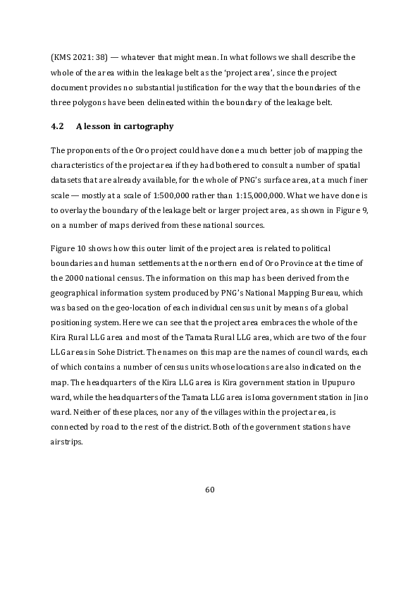
Figure 10: Kira and Tamata LLG areas in Oro Province


Source: PNG 2000 national census GIS.

4.2.1 Topography

The KMS project document states that the project area ‘comprises of the Owen Stanley
Range and plain low-lands’ (KMS 2021: 15). The highest point in the Owen Stanley
Range is Mount Albert Edward, which is 3810 metres above sea level and is located on
the very edge of the leakage belt, close to the intersection between the two LLG areas
and the border of Central Province. The project document goes on to state that three
‘major’ rivers cut across the project area, ‘viz the Mai Anna River, Wana River and Tavi


                                          61
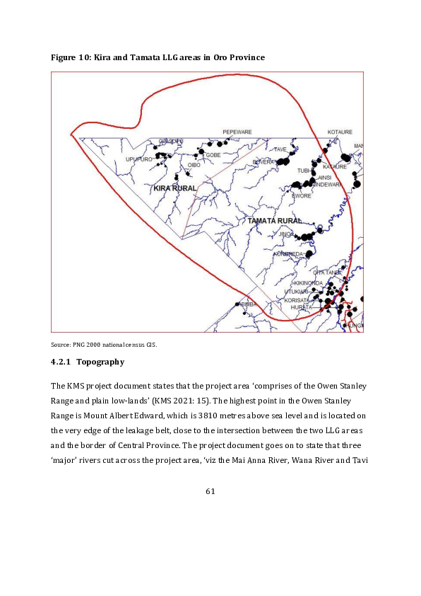
River’ (ibid.: 17). No rivers with these names are listed in the PNG Gazetteer, nor do
they appear on the 1:100,000 topographic map sheets (‘Albert Edward’, ‘Morobe’, ‘Ioma’
and ‘Kokoda’) that cover the project location. If the authors of the document had
bothered to look at these map sheets, which they do not mention, they would have seen
that five rivers flow through the project location in a northeasterly direction. The Waria
River flows through the Kira LLG area, which is also known as the ‘Papuan Waria ’. The
Eia, Gira, Mambare and Kumusi rivers flow through the Tamata LLG area. The Ioma
airstrip is located on the flood plain of the Mambare River. Most of the settlements
shown in Figure 10 are close to the banks of one or other of these five rivers at altitudes
below 600 metres above sea level.

If the authors of the Oro project document had wanted to tell us more about the physical
attributes of the project areas, they could have consulted the PNG Resource Information
System (PNGRIS). This dataset was constructed by the Division of Land Use Resea rch in
the Australian Commonwealth Scientific and Industrial Research Organisation (CSIRO)
and then bestowed on PNG’s Department of Agriculture and Livestock. The original
content of the dataset was based on a variety of field surveys carried out over a pe riod
of 20 years (1953–1972), covering 40 per cent of the total land area of PNG,
supplemented by analysis of two sets of aerial photographs with national coverage
(Keig et al. 2019). The original purpose of this exercise was to assess the environmental
constraints on ‘land use’ in order to assist the Australian colonial administration in the
formulation of its agricultural development plans (Trangmar et al. 1995).

In the construction of this dataset, the surface area of PNG was divided into polygons
known as ‘resource mapping units’ (RMUs) that can be construed as a distinctive set of
physical environments. Each RMU is defined as a unique configuration of the following
variables: (1) landform, (2) rock type, (3) altitude (taken as a proxy for temperature),
(4) relief (or slope), (5) inundation, (6) mean annual rainfall, and (7) province. A total of
4,849 RMUs have been distinguished in this way, but if provincial boundaries are


                                             62
removed from the list of definitional criteria, leaving only the six ‘physical resource
attributes’, the number comes down to 4,566. This means that the average area of each
physical environment is just over 100 km2.

Figure 11 shows how the RMUs at the northern end of Oro Province vary in relief or
degree of slope. The number 1 indicates flat land, while the number 6 indicates slopes of
more than 30 degrees. This map shows that most of the project area within Oro
Province has very steep slopes, as indicated by the numbers 4, 5 and 6.

Figure 11: Degrees of slope at the northern end of Oro Province


Source: PNG Resource Information System.


                                            63
Figure 12 shows how the same RMUs vary in the nature of their landforms. This map
shows, as one might expect, that areas with high degrees of relief consist of hills and
mountains, as indicated by the numbers 50 and 51. The remaining landforms mostly
consist of swamps (22 and 24) and river flood plains (15), with a few dissected fans
(31). A map showing the extent of inundation, which is not included here, would reveal
that roughly one third of the project area within the boundaries of Oro Province is
flooded much of the time. The RMUs subject to inundation are those whose landforms
consist of swamps or river flood plains.

Figure 12: Landforms at the northern end of Oro Province


Source: PNG Resource Information System.


                                           64
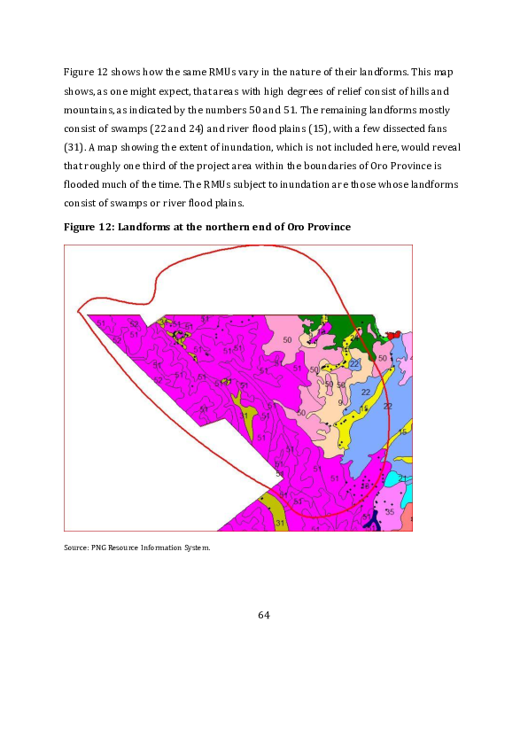
4.2.2 Agriculture

If the authors of the Oro project document had wanted to tell us more about the
agricultural practices of villagers living in the project area, or how the project itself
would impact these practices, they could have consulted the dataset produced by the
Mapping Agricultural Systems Project (MASP). This dataset was constructed by
researchers from the Australian National University and PNG’s National Agricultural
Research Institute during the course of the 1990s. Their primary aim was to determine
the relative sustainability of local agricultural systems under conditions of rapid
population growth (Allen et al. 1995).

These systems have been mapped onto the same base map and at the same scale as was
used in construction of the PNGRIS dataset. Areas of indigenous land use originally
delineated by the CSIRO scientists (Saunders 1993a; Bellamy and McAlpine 1995) have
been grouped into a total of 287 systems across the whole of PNG. These systems are
distinguished from each other by one or more of six variables that can be taken as
alternative measures of agricultural intensity. The six variables are: (1) the type of
fallow vegetation cleared before planting; (2) the number of times the land is planted
before being returned to fallow; (3) the period of time for which the land normally lies
fallow; (4) the most important crops being cultivated; (5) the techniques used to
maintain soil fertility (aside from fallowing); and (6) the segregation of crops within or
between garden sites. These agricultural systems have also been allocated to provinces,
so some of the 287 systems are counted more than once in the dataset because they
occur in more than one province (Allen et al. 2002).

Figure 13 shows (in purple) the areas of land used for village agriculture within and
beyond the outer limits of the KMS project area when the MASP dataset was
constructed. These areas include land being actively cultivated and land in fallow. The
land in fallow is covered by successional regrowth, some of which is secondary forest.
Fallow vegetation growing on land previously used as a garden site is cleared and often

                                             65
burnt before crops are planted. After one or two years under cultivation, the site is
abandoned and the land is left to a natural recovery, although bananas and other fruits
continue to be harvested. Land in fallow is a source of house building materials a nd
medicines and is used for hunting pigs and small marsupials. There is hardly any
resemblance between the area of agricultural land use shown in Figure 13 and the areas
of ‘leakage’ shown in the KMS project document (KMS 2021: 36).

That part of the project area that lies within Oro Province features two agricultural
systems. Both extend north into Morobe Province where they would have a different
number attached to them. All agricultural systems in Oro Province have a number
beginning with 6 because that is the number of the province in the national census.
System 601 is mostly confined to the catchment of the Waria River and hence to the Kira
LLG area. Sweet potato and other root crops are harvested within a year of being
planted and gardens are then left fallow for more than 15 years. Planted sago grows in
the valley bottoms and is eaten between June and September, when taro from the
gardens is not available. Coconuts are planted in village settlements on benches high
above the rivers, and also along the sides of streams in the valley b ottoms. System 603
is located on the almost flat alluvial flood plains of the major rivers. Some parts of the
system are flooded from time to time, though not to the extent that would preclude any
form of agriculture. Most gardens are located near river banks so people can reach them
by canoe. Only in the western part of the system are gardens made on slightly higher
dissected fans. Three root crops (sweet potato, taro and yam) are planted in separate
gardens. Bananas are planted everywhere. Two annual plantings are made before a
fallow lasting 15 years, so land is used at twice the intensity of the other system.


                                            66
Figure 13: Indigenous agricultural systems in the KMS project area


Source: Mapping Agricultural Systems Project.


4.2.3 Logging

If the authors of the Oro project document had wanted to include a more accurate
picture of commercial logging concessions in the project area, they could have resorted
to the maps produced by the PNGFA. The PNGFA maintains a geospatial database,

                                                67
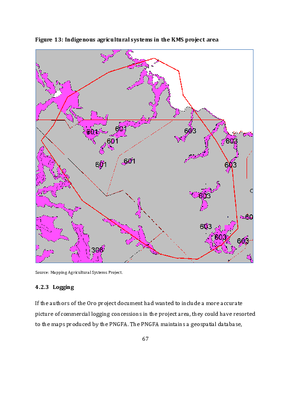
currently known as the Forest Resource Information Management System (FRIMS),
which contains maps of each province that show: (1) types of vegetation; (2) the
boundaries of current and potential selective logging concessions in what are counted
as ‘production forests’; and (3) environmental constraints to logging operations. The
maps in the most recently published version of this database (Turia et al. 2019) were
updated between 2012 and 2016. The maps showing types of vegetation (or ‘land
cover’) and constraints to logging use the system of classification that was developed by
the CSIRO scientists who produced the PNGRIS dataset (Saunders 1993b;
Hammermaster and Saunders 1995; McAlpine and Quigley 1998). The constraints to
logging identified in the FRIMS dataset are variables already identified in the PNGRIS
dataset — most notably degrees of altitude, slope and inundation.

Figure 14 shows five forest areas in the vicinity of the KMS project area that have been
or might be subject to a selective logging concession. The Morobe Coast forest area,
which overlaps the outer limit of the KMS project area, was subject to a TRP agree ment
with local landowners that lasted from 1991 to 2006, but is now designated as a
‘proposed’ concession (Turia et al. 2019: 99). This means that logging might be resumed
if the landowners were to sign a Forest Management Agreement (FMA) under the terms
of the current Forestry Act The Kumusi and Ioma Block 4 forest areas are designated as
active concessions, even though they are based on TRP agreements that should have
expired by now (ibid.: 50). Both of these forest areas are wholly beyond the outer limit
of the KMS Oro project area. The Ioma Block 5 forest area, which overlaps this outer
limit, and is bounded on its western edge by the Mambare River, is also designated as an
active concession because it is covered by an FMA that was signed in 1997, but no
logging has so far taken place in this area. The last of the active concessions covers the
Yema Gaiapa forest area, which is wholly included within the KMS Oro project area.
Logging of this area has been taking place at intervals since it was designated as a Local
Forest Area (LFA) in 1989. This means that it was established under the terms of the
Forestry (Private Dealings) Act that was repealed in 1992, so the continuation of logging

                                            68
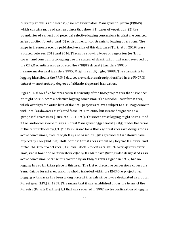
as recently as 2018 is somewhat remarkable. Comparison of Figure 14 with Figures 10
and 13 shows that the Yema Gaiapa forest area covers land that is largely uninhabited
and not used for village agriculture, which might help to explain why local landowners
have not objected to the continuation of selective logging operations.

Figure 14: Commercial logging concessions in and around the KMS Oro project
area


Source: PNG Forest Authority.


4.3      Ambition squared

The second KMS project proposal suffers from all the limitations of the Oro project
proposal, but these are even more glaring when one considers that the ‘project area’ is
three times larger and is split between two entirely different parts of the country, so


                                           69
actually consists of two different project areas (see Figure 8). The larger of these two
areas appears to cover most of Kagua-Erave District and part of Nipa-Kutubu District in
Southern Highlands Province, together with the northern part of Kikori District in Gulf
Province. The smaller area appears to cover a large part of Angoram District in East
Sepik Province and a small part of Middle Ramu District in Madang Province. Since this
proposal, like the earlier one, does not contain any maps showing the relationship
between these two polygons and the boundaries of districts and LLG areas, we would
have to resort once again to the spatial component of national census records to
establish which rural communities might be affected or involved.

At one point in the proposal, the larger polygon in the south is called Melipu, while the
smaller polygon in the north is called Keram (KMS 2022: 16). The name Melipu is not
listed in the PNG Gazetteer, so does not appear to be the name of any established
feature of PNG’s physical or social landscape. Keram is the name of a tributary of the
Sepik River that flows across the border between Middle Ramu District and Angoram
District. Since the two names are not explained or repeated anywhere else in the
proposal, they do not seem to carry much significance for the authors of the document.
However, in the absence of any other names, we shall use these two labels to distinguish
the two components of this second project proposal.

The two polygons are assigned physical attributes derived from the same international
sources as those that were used to characterise the three polygons in the Oro project
area, so there is no point in repeating the criticism that we have already levelled at this
form of description. Nor is there space here to show how all of the national datasets
discussed in the previous section can be used to provide a far more detailed account of
the physical and social characteristics of these two new polygons, especia lly because of
their greater size. Even from a cursory examination of the evidence, there is nothing
that the Keram and Melipu polygons obviously have in common except that they are
sparsely inhabited and contain a large amount of forest. But that would be true of many


                                            70
other areas of comparable size, so it is not clear why these particular areas have become
the focus of attention for the project proponents. The only way in which the authors of
the project document deal with this question is by claiming the support of local
landowners. But that claim, as we shall see, is almost certainly unfounded.

If the authors of this second proposal had bothered to consult the published version of
the FRIMS dataset, they could easily have discovered that there is only one active
logging concession in either of the two project locations. This is the one known as
Turama Extension in official records of round log exports from PNG. It is the largest
active logging concession in PNG, covering a total of 1.3 million hectares of land in
Kikori District, and is based on three FMAs signed by local landowner representatives in
1995.

The FRIMS dataset shows one proposed logging concession, in a forest area called
Polopa, in the northern part of the Melipu project area. This covers about 120,000
hectares of land, part of which is in Kikori District but most of which is in Kagua -Erave
District (Turia et al. 2019: 31, 50). Logging of this area would be constrained by the high
degree of slope or relief. The FRIMS dataset also shows three proposed concessions in
the Keram project area, in the southern part of Angoram District, south of the S epik
River, with a combined area of 840,000 hectares, but it also shows that ‘serious’ or
‘extreme’ inundation throughout the Sepik floodplain is a major impediment to any
future logging operations (ibid.: 86–7). There are no proposed logging concessions in
the small part of Madang Province that appears to be part of the Keram project area,
and inundation would also be a major constraint to logging in this area.

4.4     Misconceived and mysterious drivers

One might expect a REDD project proposal to provide a sensible historical account of
current drivers of deforestation and forest degradation in the project areas, preferably
with measurable indicators of change, and use this as the basis for predicting wha t

                                            71
might happen in the future, with or without the intervention being proposed. Neither of
the KMS project proposals has managed to produce such an account.

Both proposals contain ‘risk maps’ that divide the initial polygons into smaller polygons
or pixels that are assigned one of five degrees of risk of deforestation based on
calculations that make not the slightest reference to any of the datasets we have already
discussed (KMS 2021: 44–6; 2022: 43–6). The wording in the relevant sections of each
project document is almost identical and illustrates the pseudo -scientific language that
KMS has used to lend a veneer of credibility to its calculations. For example, the source
of the information used to calculate the degree of risk is explained as follows:

     Based on the identification & analysis of deforestation agents and to Project of
     quantity of future deforestation, the factor maps were prepared by obtaining the
     data such as roads, locations, waterways etc., from the open street maps. In this
     criteria, we used empirical approach to assess wall-to-wall approach from socio-
     economic surveys, expert opinions, and field knowledge to estimate the
     deforestation in reference region using empirical approach. This approach was
     preferred due to lack of information of the areas deforested in the historical
     deforestation. (KMS 2022: 43)

If the reader is wondering what ‘open street maps’ have to tell us about parts of PNG
that have hardly any roads in them, the reference is to a dataset managed by a German
organisation called Geofabrik (https://www.geofabrik.de/data/download.html). The
reader is not told how the ‘wall-to-wall’ approach was used to obtain any additional
information to supplement the street directories.

In both project proposals, it is stated that ‘85–95% of the forested area would be
deforested in the case of the absence of the Project in the lifetime of the Project’ (KMS
2021: 35; 2022: 36). This conclusion is said to be based on ‘literature review, fie ld visits,
hybrid Google earthmaps and expert consultations’. The risk maps actually show a low


                                             72
risk of deforestation in substantial parts of each polygon, so it is not clear how this risk
is going to increase between 2017 and 2117, which is the ‘lifetime’ of each project. None
of the literature contained in the reference lists at the end of the two project documents
is specific to PNG, nor is there any indication of which ‘experts’ were consulted in the
production of these documents.

In both project documents, the drivers or agents of deforestation and forest degradation
are broadly specified by means of a statement that native forests have been ‘under the
tremendous stress due to the logging, shifting agriculture, and plantations’ for several
decades (KMS 2021: 4; 2022: 4). The number of decades is not specified. There are
certainly some forms of agricultural activity in all three of the KMS project areas,
although ‘plantations’ are not easily identified. As we have seen, there is a history of
commercial logging in two of these areas, though not in the third one.

Let us now consider how the authors of both project proposals have managed to
misconceive the threats posed by these two forms of economic activity, and how they
have managed to invent some additional drivers of environmental change that are not
present at all.

4.4.1 Agriculture

The KMS project documents make no reference to a recent assessment of ‘forest and
land use change’ in PNG over the period from 2000 to 2015, which was undertaken by
forestry officials supported by experts from the UN’s Food and Agriculture
Organization. According to this study, 253,847 hectares of native forest disappeared
between 2000 and 2015, nearly all of this former forest was converted to ‘cropland’, and
subsistence agriculture accounted for 64 per cent of this loss (GPNG 2019: 53). This
assessment needs to be treated with some caution because the deforestation caused by
indigenous systems of shifting cultivation is normally a temporary, not a permanent,
phenomenon. The secondary forest fallows found in many of these systems absorb


                                            73
more carbon dioxide than primary or ‘virgin’ forests, so the systems themselves
contribute little or nothing to greenhouse gas emissions over the course of the cycle of
clearance, cultivation and regeneration (Filer et al. 2009).

The two KMS project documents make identical statements about the contribution of
village agriculture to the process of deforestation and forest degradation. They say that
‘shifting cultivation is commonly used for clearing forest’, that ‘a large portion o f the
forests are being converted to permanent agriculture and long fallow shifting
cultivation’, that ‘most of the deforestation was done by the poor farmers and poor
villagers who rely on forest lands for agriculture and fuel wood collection’, and that
‘cash-crop production’ is adding to the damage caused by ‘subsistence farming by using
fire’ (KMS 2021: 4, 13, 39, 42; 2022: 4, 14, 42, 82). The authors of these documents
obviously think that the local agricultural systems in all three project areas have
identical effects on the forest around them, despite the enormous distance between the
three locations.

Since we have not provided summary accounts of what we already know about the
different agricultural systems in the Keram and Melipu areas, let us just consider what
we know about the dynamics of the two systems in the Oro project area. Although there
may be some places in PNG where villagers have begun to clear gardens — or even
establish ‘plantations’ — in areas that were not previously used for agriculture, this
does not seem to be one of them. As in many other parts of the country, the typical
response to population growth has been to shorten the fallow period on land already in
use (Allen and Bourke 2009). This could entail a decline in the area of secondary forest
at any given moment in time, but would not have any effect on the area of primary
forest. In other words, we have no reason to think there has been any change in the
boundaries of the polygons shown in Figure 13 since the local agricultural systems were
surveyed in the 1990s.


                                             74
Since villages west of the Kumusi River lack road access to the provincial capital or
other parts of Oro Province, there is very little cash cropping. The Australian colonial
administration encouraged the planting of Arabica coffee in what is now the Kira LLG
area in the 1970s, but local villagers were no longer harvesting it in 1995. There is some
smallholder oil palm cultivation in villages east of the Kumusi River, but not in that part
of the Tamata LLG area that lies within the KMS project area. The KMS project document
does not explain how further development of the road network might alter this
situation.

If a REDD project were to be implemented in areas of forest that are not presently used
for village agriculture, as shown in Figure 13, then local villagers might well be able to
feed themselves for several years to come by continuing to grow food in the a reas
where they have already been growing it for centuries. And if they were to receive a
share of the revenue generated by the sale of forest carbon credits, this might
compensate for any restriction imposed on any other use they make of resources in the
primary forest. However, there is little reason to suppose that KMS will deliver on such
a promise when they cannot tell the difference between primary and secondary forest
and have so far given no thought to the question of how payments will be made to lo cal
landowners, how they might be expected to spend the money they receive, or how the
revenue from carbon credits will serve to reduce the rate of deforestation or forest
degradation.

The villagers and landowners in the Keram and Melipu project areas might fare worse
than those in the Oro project area, since the second project document appears to show
that their ‘leakage belt’ — the area where they would still be allowed to practice
subsistence agriculture — is confined to a very small ring around the outer edge of the
forest areas from which they would ideally be excluded (KMS 2022: 33). But then again,
we do rather doubt the capacity of KMS or anyone else to exercise such a power of
exclusion.


                                            75
4.4.2 Logging

Both KMS project documents assert that ‘demand for the unprocessed logs from these
areas from the Asian market is the greatest cause of the forest loss’ (KMS 2021: 4; 2022:
4). It is true that none of the logs harvested by commercial logging operations in these
areas are processed onshore, but it is not so clear that these operations have been
causing large areas of forest to be ‘lost’. Since both project are primarily intended to
reduce emissions from a process of ‘unplanned’ deforestation, there might be some
excuse for the proponents to ignore those logging operations that have already been
authorised by the PNG government. But that is not a reason to simply ignore the
question of how logging operations might contribute to the process of deforestation and
forest degradation over the course of the coming decades.

When considering the contribution of large-scale commercial logging operations to this
process, one needs to recognise the distinction between selective logging operations,
which only remove trees of a certain size and leave the rest of the forest to regen erate,
and forest conversion operations, in which the whole forest is cleared and replaced by
cash crops such as oil palm. In PNG these forest conversion operations are known as
agro-forestry projects. In the PNG government’s recent assessment of ‘forest a nd land
use change’, agro-forestry projects rank second after subsistence agriculture as a driver
of deforestation between 2000 and 2015, while selective logging operations are held
responsible for 92 per cent of the forest degradation that took place during those years
(GPNG 2019: 53, 56–8). Forest conversion concessions are not shown on the maps in
the FRIMS dataset, but none have so far been granted over the forests in the three KMS
project areas, and none is likely to be granted in future because the ar eas in question
are unsuitable for any kind of large-scale agriculture. If this is what the authors of the
KMS project documents mean when they say that ‘a large portion of the forests are
being converted to permanent agriculture’ (KMS 2021: 4; 2022: 4), then they are clearly
wrong.


                                            76
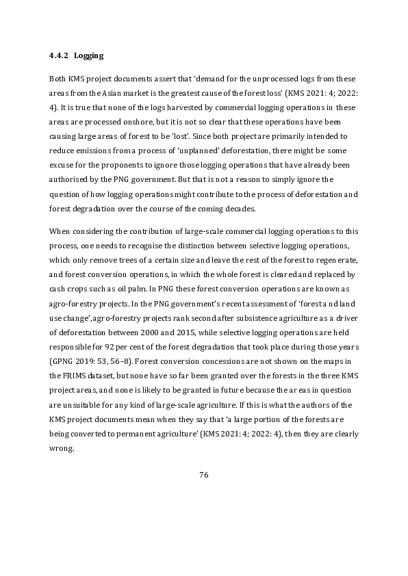
As we have seen, there are only two selective logging concessions that have recently
been operational in the three KMS project areas — one in the Oro project area and one
in the Melipu project area. Figure 15 shows the volume of logs that have been exporte d
from these concessions in recent years. The volume exported from the Turama FMA
area is obviously much greater than the volume exported from the Yema-Gaiapa LFA,
but the former is a much larger area and only part of it is included within the KMS
project area called Melipu. No logs have been exported from either concession since
2020, which could mean that the merchantable timber resource in both concessions has
been exhausted — at least for the time being. The KMS project documents have nothing
to say about what might be done to prevent the resumption of logging in forest areas
that have already been degraded by selective logging operations, or how forest carbon
credits might be generated from such action.

Figure 15: Round log exports (in cubic metres) from two selective logging
concessions

 350,000


 300,000


 250,000


 200,000


 150,000


 100,000


  50,000


       0


                              Turama Extension FMA   Yema Gaiapa LFA


Source: SGS annual reports.


                                                77
The first KMS project document also fails to explain what action might be taken to
counter the threat of forest degradation posed by the existence of the FMA that covers
the forest area known as Ioma Block 5 (see Figure 14). Questions were raised over the
legal validity of the FMA and the long-term sustainability of a selective logging
operation back in 2001 (GPNG 2001a). From experience in various parts of PNG, the
likelihood of a concession being granted tends to diminish with the passage of time
since the FMA was executed. The explanation commonly lies in the failure of local
landowner representatives to agree on which logging company should be chosen and
how the timber royalties or other benefits should be distributed. In this instance, we
know that the president of the Tamata LLG expressed his opposition to the grant of a
concession in 2010 (Anon. 2010), and that the current governor of Oro Province, Gary
Juffa, also expressed his opposition before he was elected to the national parliament
(Anon. 2011).

The FRIMS dataset delineates a number of ‘proposed’ selective logging concessions in
all three of the KMS project areas, but it is unlikely that any of these proposals will come
to fruition in the near future. The reason for this is that the National Fores try
Development Guidelines attached to the current Forestry Act require that an FMA
should cover an area containing at least 100,000 hectares of ‘commercially manageable
forest’ that can sustain an annual harvest of 70,000 cubic metres of timber over a 35 –
40-year period, if the logs are going to be exported, or 30,000 cubic metres if they are
going to be processed onshore (GPNG 1993). None of the proposed concessions shown
in the FRIMS dataset can possibly meet these criteria, so it seems their inclusion
represents some form of wishful thinking on the part of forestry officials.

In the Oro project area, these proposed concessions seem even more implausible
because they are located to the west of the Yema Gaiapa concession, where the degree
of slope or relief is itself a major constraint to any commercial logging operation. The
KMS project document concedes as much when it states that ‘[t]he overall topo[graphy]


                                            78
of the project area is extremely rugged, particularly in the highlands, which are
characterized by sheer slopes, sharp ridges, fast-running rivers or in other words high
mountain ranges intersected by alpine valleys and plateaus (KMS 2021: 15). Figure 16
illustrates this point. It is almost certain that this area is never going to be logged, so the
only justification for a REDD project would be the threat posed by the expansion of
subsistence agriculture. As we have seen, this threat is grossly exaggerated.

Figure 16: A view of part of the KMS Oro project area southeast of Kira airstrip


Source: photograph by Bryant Allen.


                                              79
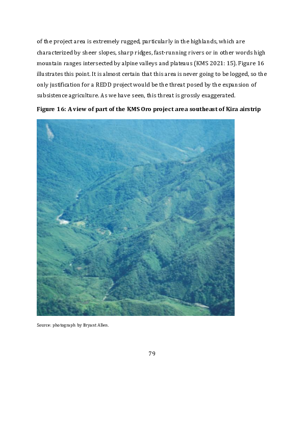
4.4.3 Mysteries

Aside from the projected encroachment of village agriculture and commercial logging,
the KMS project documents posit some additional drivers of deforestation and forest
degradation that simply beggar belief.

Both documents identify ‘ranchers’ as a third agent of deforestation, alongside the
farmers and loggers (KMS 2021: 35; 2022: 36). Although the Australian colonial
administration did try to introduce the practice of cattle ranching to some parts of the
country, the number of cattle has steadily declined since Independence (Vincent and
Low 2000). Cattle ranches are now few and far between, and none have been reported
from any of the three KMS project areas.

Both KMS project documents state that timber harvested from native forests is being
used for the production of charcoal and bricks (KMS 2021: 30; 2022: 31). Papua New
Guineans without access to electricity use firewood or kerosene, but not charcoal, as a
source of energy, and bricks are hardly ever used as a building material, even in urban
areas.

The mysterious addition of cattle, charcoal and bricks to the list of ‘deforestation risks’
is accompanied by an even greater mystery when the Oro project document asserts that
the ‘risk map’ includes ‘[r]ailways downloaded from Diva-GIS website
(http://www.diva-gis.org/Data)’ (KMS 2021: 44). The passage containing this assertion
has not been copied across to the second KMS project document, unlike most of the
other passages that deal with such risks. That may simply be an accidental omission on
the part of the authors or a belated response to our own critique of the first document
(Hemming and Babon 2022). In any case, there are no railways in any of the three
project areas or anywhere else in PNG. We can only infer that much of the material in
both project documents has simply been copied from some other project document that
deals with an entirely different country.


                                            80
4.5    Consultation and consent

Both project proposals state that the forests to be protected are ‘directly critical to the
lives and well being of most of our people’ (KMS 2021: 4; 2022: 4). One might expect the
authors to produce some evidence of consultation with some of the other
representatives of the people they claim to represent. Yet there is no evidence of any
meetings with the seven provincial governors and eight other members of parliament
who are the elected representative of the people who inhabit the three project areas.
Nor is there any evidence of consultation with staff of the various government agencies
responsible for implementing the national laws and policies that relate to the
management of forests, land or other natural resources.

Both project documents make reference to the Climate Change (Management) Act of
2015 and the National REDD+ Strategy published in 2017 (KMS 2021: 23 –4; 2022: 23–
4), but not to any of the other statements of government policy that have been made
since KMS personnel visited the country in 2017. For example, there is no mention of
the proposal to phase out round log exports that was announced in 2019 or the
moratorium on voluntary carbon projects that was announced in 2022.

If this serves to explain the absence of any reference to recent drafts of various REDD+
project guidelines produced by the CCDA, one might at least expect there to be some
reference to the earlier guidelines that prescribe a process for securing the free, prior
and informed consent of local landowners (GPNG 2014). However, the project
proponents seem only to have taken account of Section 89 of the Climate Change Act,
which states a preference for ‘customary landholders’ to grant their consent through
their membership of incorporated land groups (ILGs) registered under the current
version of the Land Groups Incorporation Act. Although the two project documents
identify a number of ILGs whose members and executives have supposedly granted
their consent, there is barely any indication of the process by which they were


                                            81
consulted, the contents of the resulting agreements, or the mechanism whereby
payments might be made to the landowners. Furthermore, it is most unlikely that the
ILGs named in the documents are in any way representative of anything more than a
handful of the landowners in each of the three project areas.

4.5.1 Limited consent in Oro Province

The Oro project document states that KMS has entered into an agreement with four ILGs
that supposedly share ownership of all the customary land in the project area. The
shares attributed to each of the four groups are shown in Table 6. If we consult the
pages of the National Gazette, where applications for land group incorporation are
advertised, we find that one of the four groups (Konoma) applied in September 2017
and was registered in April 2018, while the other three groups applied in November
2017 and were registered in September 2018. The application and registration notices
specify the village or villages in which the members of each group are supposedly based
but do not specify the extent of their land claims.

Table 6: Village locations and land claims of four ILGs in Oro Province

 Land group               Village(s)                     Land claim (ha)
 Konoma                   Sedema                         264,000
 Mawae                    Yema, Gobe, Agotame,            59,300
                          Pepeware
 Owasupu                  Avihasa                         77,100
 Pore                     Kira                           18,000

Sources: PNG National Gazette 2017–2018; KMS 2021: 8.


The 2011 national census recorded five council wards and 30 rural villages in the Kira
LLG area. Ovasupu was the name of one of the council wards, and Avihasa was one of
the ten villages in that ward. Sedema was one of five villages in the Oibo ward. Kira was
one of seven villages in the Upupuro ward. Agutame and Pepeware were two of the

                                                    82
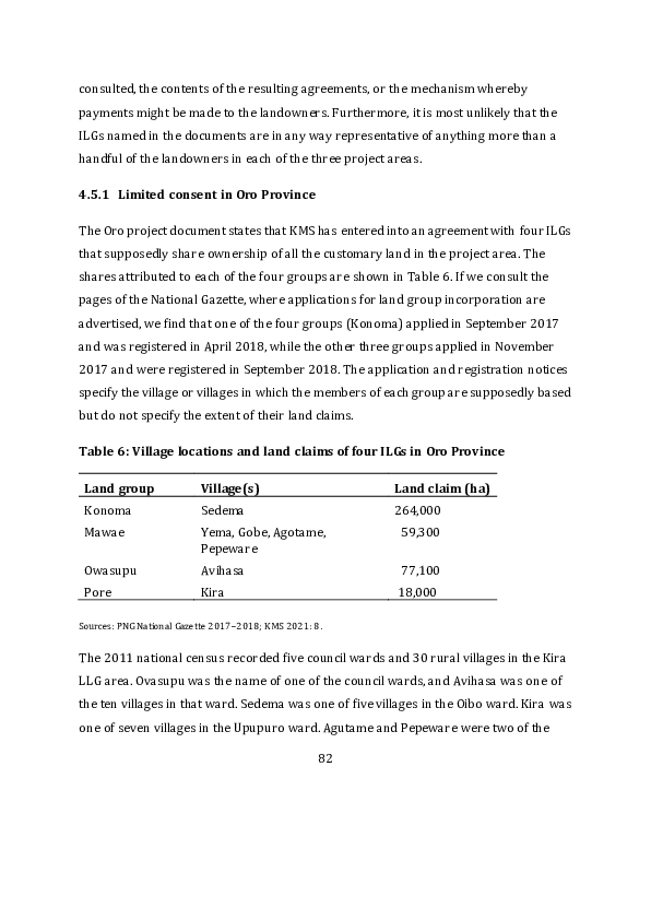
three villages in the Pepeware ward, while Gobe and Iema were two of the five villages
in the Gobe ward. The locations of these seven villages are highlighted in Figure 17. The
combined population of the seven villages that supposedly contained the members of
these four land groups was 1,195, which was just over one third of the rural village
population resident in the Kira LLG area. Sedema village only contained 78 residents,
and even if all of them were members of the ‘Konoma’ clan, it would seem rather
remarkable that such a small number of people were recognised as the customary
owners of such a large area of land — about 60 per cent of the 418,000 hectares
supposedly contained in the larger KMS project area. Most of this land lies beyond the
boundaries of the Kira LLG area. No doubt many of the 15,000 villagers living in the
Tamata LLG area would have some cause to complain about the extent of this land claim
if they ever got to hear about it. There is no evidence to suggest that any land groups
based in the Tamata LLG area had been signed up to the KMS project, so perhaps we are
meant to infer that they were all ‘squatting’ on land owned by the Kira people. Perhaps
the same inference should be drawn about any people resident in those parts of the
KMS project area that are not even located within the boundaries of Oro Province. The
National Gazette gives no indication that any other land groups from this larger project
area have been incorporated since 2013.

According to a newspaper article published in September 2019, members of these four
land groups were also members of a single landowner association and shareholders in a
single landowner company called Papuan Waria Rainforest Ltd (Anon. 2019a). The
association’s chairman, Jerry Geno Noese, was quoted as saying that ‘a project proposal’
had been sent to relevant government departments and donor agencies, although KMS
was not named in the article. Mr Noese reportedly thanked staff in the Office of Climate
Change & Development for providing ‘guidance’ and staff in the Oro Provincial


                                           83
Government for supporting the process of land group incorporation. 14 He also ‘warned
recent illegal settlers in the project area ... to move out’ and said there were plans ‘to
evict illegal settlers and land grabbers in the project area’.

Figure 17: Village locations in Kira LLG area


Source: PNG 2000 national census GIS.


In April 2022, someone claiming to represent the ‘concerned clans from Kira LLG’ wrote
a letter to another newspaper in which they claimed that registration of the four groups
had involved ‘gross misapplication of land boundaries’ and a failure to recognis e the


14   The Office of Climate Change and Development was transformed into the Climate Change and
Development Authority in 2015, but Mr Noese and his allies seem not to have noticed the
change.


                                               84
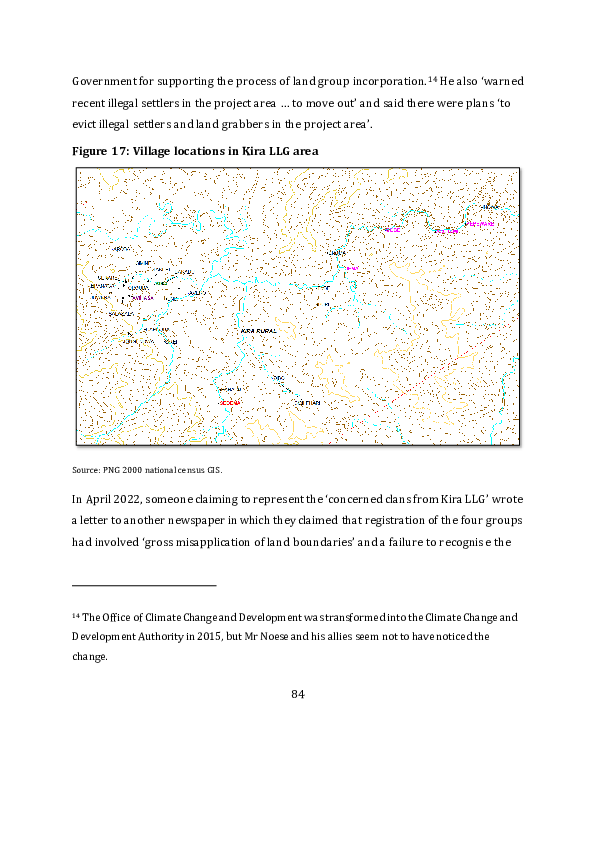
‘properties owned by different clans within the tribes’ (Anon. 2022a). The author went
on to say that ‘[m]ediation and other legal processes were not followed prior to creating
the carbon trade organisation’, and that Mr Noese ‘had used evasive and ignoran ce [sic]
tactics to avoid requests for proper mediation and consultations’. Lands Department
officials were asked to check the legal standing of the four ILGs and Governor Gary Juffa
was asked to check the legality of the ‘carbon trade plan’.

KMS summarises the process of ‘local stakeholder consultation’ by simply stating that
‘exhaustive meetings’ were held with land group and community members in the
months of March and April 2017, and that ‘information about community costs risks
and benefits was exchanged and discussed’ during these meetings (KMS 2021: 27 –8). In
a subsequent part of the document that outlines the project’s ‘monitoring plan’, it is
stated that community members would be organised into ‘squads’, ‘crews’ or ‘brigades’,
led by village ‘chiefs’ and supported by specialised ‘technicians’ and KMS ‘team
representatives’, to patrol the project area and ensure that the project agreements were
being implemented (ibid.: 84–5). There is no evidence that any such activity has actually
been undertaken since 2017.

At the very end of the document there are two photographs of people in meetings, but
no indication of when and where the meetings were conducted or who was present
(KMS 2021: 127). We might assume that both photographs were taken in 2017 were it
not for the fact that the second one shows several of the participants wearing face
masks, which probably means that it was taken after the onset of the COVID pandemic
in 2020. Since there is no evidence that KMS personnel have visited PNG since 2017, it is
not clear how the photograph found its way into the project document.

4.5.2 Minimal consent elsewhere

The second project document states that KMS has entered into an agreement with 63
ILGs that supposedly share ownership of all the customary land in the Melipu and


                                           85
Keram project areas (KMS 2022: 7–9).15 As in the case of the Oro project, the land in
question is divided between these groups, but only to the extent of being divided in two.
One part, comprising 810,000 hectares of land, is said to belong to an ILG called Melipu
Yesiki. This is presumably the whole of the Melipu project area, although this is not
clearly stated in the project document. The other part, comprising 507,100 hectares of
land, is said to be shared between the other 62 groups. There is no indication of which
groups own how much of what is presumably the project area called Keram.

If we consult the pages of the National Gazette, we do come across a group called Melipu
Yesiki, which applied for incorporation in December 2019 and was apparently
registered one week after its application was submitted to the Lands Department.
According to the relevant notices, the group is based in Sokere village in the Erave LLG
area in Kagua-Erave District in Southern Highlands Province. If this group owns
810,000 hectares of land, then it probably counts as PNG’s biggest single landowner.
The total area of the Kagua-Erave District is 349,700 hectares, and the Erave LLG area
accounts for roughly two thirds of it. There is no village by the name of Sokere identified
in the 2011 national census.

Only one of the remaining 62 ILGs listed in the KMS project document has featured in
the pages of the National Gazette since the current version of the Land Groups
Incorporation Act came into effect in 2012. This is the group called Pukpuk (meaning
‘Crocodile’ in Tok Pisin), which applied for incorporation in January 2015 and was
registered one month later, before KMS personnel arrived in PNG. According to the
relevant notices, this group is based in Lamdo village in the Arabaka LLG area in Middle
Ramu District in Madang Province. Lamdo village is also missing from the list of rural
villages in the 2011 national census. Unlike the Melipu Yesiki group, this group actually


15 It looks as if there are 64 groups in the list, but one of them (Aoroka Ampunai) appears twice.


                                                    86
managed to secure a registered title to its customary land in November 2015. The notice
of registration published in the National Gazette stated that the title covered 529,000
hectares of land, which is more than the size of the project area called Keram in the KMS
project document. Keram is actually given as the name of the land owned by the Pukpuk
group in the title notice. But the apparent size of its property is most likely an illusion.
The scale attached to a copy of the survey plan that one of us obta ined from the Lands
Department reveals that the area is in fact only 529 hectares, even though the surveyor
has written ‘529,000.00’ in the middle of it (Filer 2019: 21). If the ILG is actually based
in a single village, we might infer that the village is located on or near the banks of the
Keram River.

Issues of the National Gazette published since 2012 contain no trace of any of the other
61 ILGs listed in the KMS project document. They might conceivably be groups that
were registered before 2012, but the project document seems to acknowledge that such
groups would not be able to enter into a project agreement unless they got themselves
reincorporated under the current legislation. The only alternative is that these groups
do not exist, even on paper, except on the three pages of the KMS project document.

The passages on ‘local stakeholder consultation’ and the content of the project’s
‘monitoring plan’ have been copied, word for word, from the Oro project document to
this second project document (KMS 2022: 28–29; 69–72). As a result, the second
document also states that ‘exhaustive meetings’ were held with members of all these
real or unreal ILGs in the months of March and April 2017, at the very same time that
meetings were supposedly being held in Oro Province. Whoever copied these passages
apparently failed to notice that this contradicts the statement made elsewhere in the
second document that ‘patrolling activities’ in the Keram and Melipu project areas were
not undertaken until November 2017 (ibid.: 9). Given the enormous size of these two
areas, and the number of rural villages that they contain, it would have been quite
impossible for a single team of consultants to have consulted all of the customary


                                             87
landowners in less than a month. Since no photographs of villages or village meetings
are attached to this project document, there is no evidence that visits were actually
made to any of these villages in 2017, or that any patrols have been mounted since then.

5      Mayur Resources or Renewables

In January 2022, Australian company Mayur Resources Ltd (MRL) informed the
Australian Stock Exchange that its wholly owned subsidiary, Mayur Renewables PNG
Ltd, had been granted ‘its first forest carbon concessions in Papua New Guinea,
demonstrating material progress on its commitment to achieve “net zero” carbon
emissions for its nation building projects in PNG’ (MRL 2022a). In the webinar that
followed,16 managing director Paul Mulder said that his company was assessing three
potential concessions under the terms of an agreement with the PNGFA, and was
initiating a carbon verification process through discussions with ‘the world’s premier
REDD+ developers, marketers and carbon traders to bring the projects to fruition’. He
was expecting the first project to be verified within 18 months.

Mulder made it clear in his presentation that the point of this exercise was to offset the
carbon emissions from the Central Cement and Lime Project that he was planning to
develop in proximity to the natural gas liquefaction plant operated by Exxon Mobil in
Central Province, close to the nation’s capital, Port Moresby. This was the latest of
several business ventures that MRL had been investigating over the course of the
previous decade. One of the earliest ventures was a proposal to develop PNG’s first
large-scale coal mine, which did not go down well with environmentalists (Fletcher and


16 https://www.youtube.com/watch?v=bcFb5GKcBxI


                                            88
Kuman 2020). This proposal appears to have been shelved in favour of the quicklime
quarry and its associated carbon offsets.

In June 2022, MRL announced that it had entered into an agreement with Australian oil
and gas giant Santos to develop a ‘portfolio of nature-based carbon offset projects’ in
PNG that would preserve ‘1.4 million hectares of pristine rainforest’, beginning with an
area of ‘up to 800,000 hectares in the Western Province’ (MRL 2022b). Under the terms
of this agreement, Santos would provide MRL with a loan of 3 million US dollars to fund,
amongst other things, ‘ongoing detailed feasibility and landholder consent work’. Santos
had an interest in securing its own carbon offsets from PNG as a result of its acquisition
of the oil and gas assets of the smaller Australian company Oil Search at the end of 2021.

In a conference call related to the announcement of this new partnership, MRL
suggested that the forest area in Western Province could yield Verra -certified carbon
credits worth 100 million US dollars a year from an initial capital expenditure of 10
million dollars, that operating costs would be capped at 10 per cent of annual revenue,
that landowners would receive 54 per cent of the net income, national and provincial
governments would get 30 per cent by way of taxes and levies, while the remaining 16
per cent would accrue to the developer as a net profit (Lang 2022a). One month later,
these exciting prognostications were given a jolt when the National Forest Board
announced that it had cancelled the three forest carbon permits that covered this area
(Lang 2022b).

The forest area in question is known to forestry officials as Kamula Doso, these being
the names of two of the languages spoken by the people who claim to be its customary
owners. Its ‘pristine’ quality is partly due to the fact that very few people reside within
its boundaries. Foreign investors have been trying to get their hands on it for the past
25 years, but none has so far had much success because they have not been able to
persuade all the landowners who do or do not live there to agree on any plan for its


                                            89
exploitation or conservation. There is no good reason to think that MRL will be any
more successful in forging such an agreement.

5.1    Failure of the first FMA and the first REDD project

Between 1996 and 1998 a substantial number of land groups from four local
government areas in Middle Fly District were incorporated for the purpose of signing an
FMA that would enable the PNGFA to grant a selective logging concession over the
Kamula Doso forest area. Individuals purporting to represent 52 of these land groups
signed up to the FMA in 1998 (GPNG 2001b). The process of incorporation was not
undertaken or even supervised by forestry officials. It was organised by a landowner
company called Wawoi Tumu Holdings Ltd (WTHL), which had already entered into
some sort of partnership with Wawoi Guavi Timber Company (WGTC), a wholly owned
subsidiary of PNG’s biggest logging company, Rimbunan Hijau (RH). WGTC had been
granted concessions over three different parts of the Wawoi Guavi forest area in 1990.
These were combined into a single concession in 1992, and WGTC has been logging it
ever since. In the early 1990s, RH was attempting to obtain a concession over the
adjacent Makapa forest area, but a lengthy process of political contestation eventually
placed that concession in the hands of other Malaysian logging companies — first
Innovision and then Vanimo Jaya (Wood 1997). Logging of the Makapa concession
began in 1999 and also continues to the present day. Figure 18 shows the spatial
relationship between the three forest areas.

The Wawoi Guavi and Makapa concessions are both based on TRP agreements between
the state and local landowners that were concluded before the new Forestry Act came
into effect in 1992. These agreements did not require a process of land group
incorporation as the mechanism by which landowners would consent to the alienation
of their customary rights. Forestry officials did make some attempt to convert the
Makapa TRP into an FMA in the early 1990s, and a number of land groups were


                                           90
incorporated for this purpose, but nothing came of this effort. Nor were they entirely
satisfied with the process that led to the FMA that covered the Kamula Doso forest area.
In 1999, the National Forest Board decided to allocate the area to WGTC as an
‘extension’ to the existing Wawoi Guavi concession instead of putting it out to tender, as
was the standard practice. A subsequent inquiry by PNG’s Ombudsman Commission
found that the board had been unduly influenced by RH’s promise to construct a veneer
factory at Panakawa, close to the existing sawmill at Kamusie, but it also found that the
FMA was invalid because the individuals who signed it were not truly representative of
the 52 land groups that had been incorporated by the landowner company WTHL
(GPNG 2002). What had gradually become apparent during the course of the 1990s was
that the process of land group incorporation — at least in this part of the country — had
not had the effect envisaged by the new forest policy framework designed in 1991. It
had clearly not disrupted the relationships of partnership or patronage between
landowner companies and the various foreign investors seeking access to the forests
that grew on the land that their partners or clients did not actually own.


                                           91
Figure 18: Three forest areas in Western Province


Source: CartoGIS, ANU.


WTHL was just one of several landowner companies whose directors purported to
represent a majority of the customary owners of one or other of these three forest
areas. Some of these companies had a number of incorporated land groups registered as
their shareholders, but this did not mean that the executives — let alone the ordinary
members — of these land groups were party to the negotiations that took place
between the company directors and the assortment of foreign investors. Some of these
landowner companies were only active for the fairly brief period in which their foreign
partners or patrons were actively seeking access to local forest resources. Some were
directed or supported by local politicians whose own influence was curtailed when they

                                          92
lost an election. The company that had the best claim to represent the majority of the
customary owners of the Kamula Doso forest area — both then and now — was the one
called Tumu Timber Development Ltd (TTDL). At the last count, this company had 82
land groups as its registered shareholders, but there is no way of knowing which
particular areas of land or forest belong to which of these groups. The one thing we do
know about this company is that its directors have generally been united in their
opposition to RH and its subsidiaries, and certainly did not support the decision made
by the National Forest Board in 1999.

The Ombudsman observed that further steps to allocate a logging concession over the
Kamula Doso forest area were effectively blocked when the Morauta Government
imposed a general moratorium on the grant of new concessions in 2000 while making
simultaneous amendments to the Forestry Act that would outlaw the type of decision
that had been made by the National Forest Board in 1999. However, the moratorium
was lifted when Michael Somare succeeded Mekere Morauta as prime minister in 2002,
and litigation over the board’s decision continued until 2010, when WGTC finally
conceded that the FMA was invalid and therefore surrendered its claim over the
concession (Bird et al. 2007: 6–7; Gabriel and Wood 2015: 338).

In the meantime, the Kamula Doso forest area had become the site of a new set of
development or investment proposals that did not require the existence of a valid FMA.
By the end of 2007, two Australian entrepreneurs were attempting to garner the
support of a variety of state actors for their own proposals. Neville Harsley and his
company, Independent Timbers and Stevedoring Ltd (ITSL), were looking to use the
revenues from some sort of logging operation to fund the construction of a road
network that would connect the township of Kiunga to Wawoi Falls and enable local
villagers to access markets for their agricultural produce. Kirk Roberts and his
company, Nupan Ltd, were looking to establish a network of corporate interests
through which they could market carbon credits from the avoidance of deforestation


                                           93
and forest degradation. Both men regarded TTDL as the representative body through
which they might be able to secure some semblance of landowner consent to their
proposals (Filer and Wood 2012: 671–3).

It was Harsley who arranged for TTDL to secure a Special Agricultural and Business
Lease (SABL) from the Department of Lands and Physical Planning in 2009. The idea
was that TTDL would then issue a sub-lease to ITSL so that the latter could exploit some
loopholes in the Forestry Act by obtaining a Forest Clearing Authority or a number of
separate Timber Authorities to authorise the logging operation. Gazettal of the lease
sparked a complex legal struggle between the two entrepreneurs and their local
supporters for control of the TTDL board (Wood 2015). Although TTDL submitted a
REDD project proposal to the former equivalent of Verra in 2010, it looked as if Harsley
had won this battle by the end of that year because Roberts had given up and gone
home (Filer and Wood 2012: 673–4). However, Harsley’s own activities were then
subjected to critical scrutiny by a Commission of Inquiry into SABLs that discovered the
absence of genuine landowner consent to most of those that were investigated (Mirou
2011, 2012, 2013: 510–30). The SABL granted to TTDL was then cancelled by the
National Executive Council in 2014 (Filer and Numapo 2017). 17

5.2     Fresh confusion in the corridors of power

The new plan to turn the Kamula Doso forest area into the site of a ‘forest carbon
concession’ was almost certainly conceived after Prime Minister James Marape had


17 The subsequent story of attempts by ITSL and its mysterious shareholders to maintain control over the

area (or receive massive amounts of compensation from the PNG government for its purported act of
expropriation) are recounted in an article that can be viewed at https://pngicentral.org/reports /how-a-
murky-foreign-outfit-attempted-to-bankrupt-png.


                                                   94
appointed Walter Schnaubelt to replace Solan Mirisim as forests minister in January
2021. Schnaubelt nominated Keith Iduhu, a lawyer by profession, to be his
representative on the National Forest Board, and Iduhu was duly elected as chairman by
the other members. Negotiations with MRL may not even have started until the second
half of the year, after John Mosoro had been appointed to replace Tunou Sabuin as the
managing director of the PNGFA. Between them, Iduhu and Mosoro arranged for Mulder
to seek the board’s support for his new scheme. The fourth player in these negotiations
was Chalapan Kaluwin, director of the Centre for Climate Change and Sustainable
Development at the University of PNG, who was acting as a consultant to MRL at the
same time that he was being asked to review the Forestry Act in order to create a new
legal space for this kind of project to be authorised.

The plan was first made public in October 2021, when journalist Dale Luma conducted
an interview with Schnaubelt and Iduhu after the two men had attended a session on
climate change at the Dubai World Expo. Iduhu told Luma that

     forest carbon would be classified as forest produce and not just timber hitting the
     ground. That is an area the [PNGFA] is looking into and also advancing the
     mandate of the authority into this unique area to capture forest carbon and put it
     on as a viable commodity for economic development and exchange of both
     sustainable renewable energy going into the future. (Luma 2021)

Mention was made of an 800,000-hectare forest area, but Kamula Doso would not be
revealed as the main target of this exercise for several months. Schnaubelt’s support for
the new scheme may seem rather odd, given his opposition to the forest carbon project
proposed by NIHT in his own electorate. But Schnaubelt had nothing much to lose by
supporting the deal with MRL, so long as that deal was only concerned with forests in
other electorates. Nor does he seem to have played an active role in the negotiations
before he authorised the grant of three forest carbon permits to MRL shortly before he
was ousted from the ministry.

                                            95
The architects of the new scheme may or may not have been aware of legal advice from
the State Solicitor to the effect that the PNGFA did not have the power to authorise
REDD projects once that power had been vested in the CCDA by means of the Climate
Change (Management) Act of 2015 (GPNG 2016). But they do not seem to have taken
account of the fact that forestry officials had already been engaged in the process of
securing landowner consent to a new FMA that would allow for the grant of a new
selective logging concession over the Kamula Doso forest area. 18 They could have used
their knowledge of this fact to bolster their own case for a REDD project that would
avoid the imminent threat of forest degradation, but there is no evidence that they did
so.

According to Ruth Turia, former director for policy and planning in the PNGFA, a new
FMA covering all three of the ‘blocks’ in the Kamula Doso forest area was ‘executed’ in
November 2020, two years before the National Forest Board was apprised of Mulder’s
forest carbon scheme. However, information obtained from other sources suggests that
the new FMA might have been as faulty as the one that was signed in 1998. We have
first-hand evidence of forestry officials discussing the option of a new agreement with
some of the local landowners at Kamiyame village in November 2019. The officials
attending this three-day meeting left most of the first two days’ discussions to
landowner representatives. Figure 19 shows a blackboard on which someone has
written the names of 15 ILGs whose executives were aiming to be recognised as
customary owners of the forest resources in Block 1, but we do not know who might
have signed what sort of document at the end of the meeting. The 15 ILGs whose names


18 Unlike most of his predecessors, John Mosoro was not recruited from within the ranks of the National

Forest Service, and may not have had the opportunity to consult with other senior officials before he
endorsed the new scheme.


                                                    96
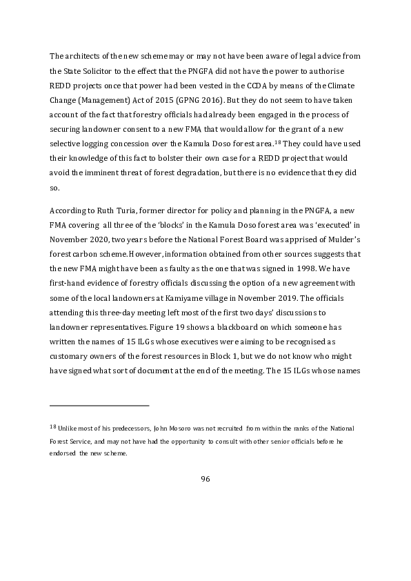
appeared on the blackboard were amongst the 52 that were shortly afterwards
registered as shareholders in a new landowner company called Kamula Doso Forest
Resource Development Ltd (KDFRDL). The directors of this company presumably
arranged for additional meetings to be held with representatives of the remaining ILGs
in order to gain their support for the new FMA.

Figure 19: Land group validation process in Kamiyame village, November 2019


Source: Photo by Michael Wood.


We do not know the extent to which forestry officials were involved in any additional
meetings, nor do we know the extent of the support that the directors of KDFRDL were
seeking or obtaining from RH or Vanimo Jaya. Both logging companies would have a
fairly obvious interest in logging the Kamula Doso forests, since the volume of
merchantable timber in the Wawoi-Guavi and Makapa concessions is steadily
diminishing and the TRP agreements on which they are based are due to expire within
the next decade. The volume of round log exports from both concessions shows a
downward trend in recent years (see Figure 20). RH might be especially keen to secure

                                           97
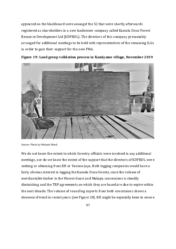
a new source of raw material for its facilities at Panakawa and Kamusie, which can
process up to 350,000 cubic metres of timber each year, but have not been operating at
full capacity for some time (Pouru 2020). And RH might well have expected, on the basis
of past experience, to be awarded the new concession if and when it were put out to
tender by the National Forest Board, especially if it had a strong show of support from
the local landowners.

Figure 20: Round log exports (in cubic metres) from two existing concessions,
2016-2022
 200,000

 180,000

 160,000

 140,000

 120,000

 100,000

  80,000

  60,000

  40,000

  20,000

       0
               2016           2017      2018            2019           2020   2021   2022

                                     Wawoi Guavi TRPs          Makapa TRP


Source: SGS Annual Reports.


However, the extent of this support was still open to question for two reasons. The 52
ILGs that were registered as shareholders of KDFRDL do not appear to have been
reincorporated in accordance with the provisions of the new version of the Land Groups
Incorporation Act that came into effect in 2012, which casts some doubt on their legal
capacity to enter into any new agreement with the government or anyone else. At the

                                                  98
same time, the directors of the other landowner company, TTDL, in which many of these
groups are still registered as shareholders, have continued to oppose the grant of a new
logging concession to either of the logging companies already operating in that p art of
the country.

From the pages of the National Gazette we learn that 25 land groups that look very
much like claimants to ownership of some parts of the Kamula Doso forest area did
indeed apply for incorporation under the new legislation on the same day in November
2019, but their names do not resemble those of the groups listed on the blackboard in
Figure 19, only one or two of them were listed as shareholders of KDFRDL, and most are
not even listed as shareholders of TTDL. On the other hand, it seems that they have not
been granted certificates of recognition. Three years later, in November 2022, a
separate collection of 18 land groups applied for recognition on the same day, and were
duly registered on the same day in March 2023. Most of these groups are amongst the
registered shareholders of both KDFRDL and TTDL, but it is hard to see how their
incorporation could retrospectively justify an FMA that should have been signed by the
representatives of a considerably larger number of ILGs.

5.3    Reign of terror on the ground

If RH or Vanimo Jaya were actively seeking landowner support for a new FMA in 2019,
they might have changed their minds since then. One of the national newspapers
reported a raid on Vanimo Jaya’s logging camp at Sasereme (or Sasalema), in the
Makapa forest area, in November 2019, although the raid probably took place in
September or October. According to the newspaper report, a group of well-armed Huli
bandits from Hela Province had travelled down through Southern Highlands Province,
and had been terrorising villagers in the area around Wawoi Falls before they
descended on the logging camp, where they murdered two Chinese storekeepers while
robbing their trade store (Anon. 2019b). Shortly afterwards, the bandits extended their


                                           99
reign of terror into the Wawoi Guavi concession. During one raid they kidnapped
workers from the logging camp at Kamusie and, according to some sources, drove them
to Wawoi Falls before releasing them on payment of another substantial ransom (Anon.
2020a). Local villagers were also terrorised, trade stores were ransacked, women and
girls were raped.19 Our informants have told us that another raid was conducted in June
2021, but the gangsters were chased away after two gang members had been shot.

Security concerns were a major factor in the suspension of logging and processing
operations in the Wawoi Guavi concession in 2020 and 2021 (Anon. 2020b; Honey
2021). This was confirmed in a recent statement by Kanawi Pouru, RH spokesman and
current president of the Forest Industries Association, who blamed the raids for closure
of the Panakawa plywood and veneer mill in 2020 and said that their continuation
might now lead to closure of the Kamusie sawmill as well (Anon. 2023b). In a recent
petition to the prime minister, local landowners claimed that RH alone had paid out 2.8
million kina in ransoms to kidnappers since 2020 (Woti 2023), though we have not
been able to verify this figure.

The reign of terror in this part of Western Province was only brought to the attention of
an Australian audience when the bandits held a team of archaeologists to ransom in
March 2023, but the threat to the logging industry shows no signs of abating (Chand ler
2023). It would be somewhat ironic if these activities had the simultaneous effect of
dissuading the logging companies from venturing any further into the forest while


19 A more recent raid on the village of Walagu, which lies to the north of the Wawoi Guavi concession,

resulted in the abduction and rape of 17 women and girls and caused national outrage (Anon. 2023a). The
Huli gang responsible for this assault is said to have numbered 40 men, some of whom may well have
been involved in previous raids.


                                                   100
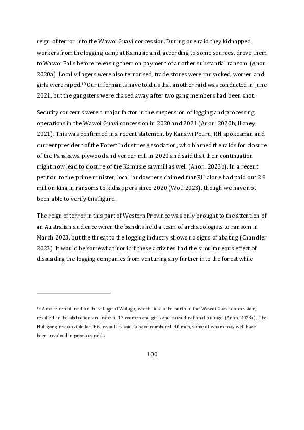
making it even harder for Paul Mulder’s enterprise to acquire forest carbon credits on
the basis of a claim to be protecting the forest from this threat of industrial exploitation.

5.4     The current legal stalemate

There is no evidence to suggest that Walter Schnaubelt’s removal from the forests
ministry at the end of 2021 was related to his endorsement of the forest carbon permits
issued to MRL. However, Solan Mirisim’s return to the ministry that he had previously
held in 2019 and 2020 does seem to have ushered in a change of heart amongst
members of the National Forest Board. Chairmanship of the board was transferred from
Keith Iduhu to Mirisim’s own nominee, Faith Barton Keene, who had previously held
that position in 2020, when the board supposedly approved the new FMA. 20

The board resolved to cancel the forest carbon permits in April 2022, but news of this
decision was only made public three months later, by means of an advertorial in the
local newspapers, after MRL had announced its new partnership with Santos (Anon.
2022b). The reason given for the board’s decision was that MRL was not registered as a
‘forest industry participant’, but that omission could easily have been remedied. The
State Solicitor’s previous legal advice, or the legal status of the new FMA, could have
been more important factors in the decision. Paul Mulder claims that he was not even
informed of the board’s decision until the day before it was broadcast to the public, and
he responded by declaring that MRL would challenge the legality of the board’s decision
(Anon. 2022c).


20 Iduhu then set his sights on getting himself elected to the national parliament, where he now

represents the newly created electorate of Hiri-Koiari in Central Province.


                                                   101
Even before the board had made its decision, MRL had engaged a local company called
Social Environmental Research and Consultancy Services (SERACS) to begin the
‘landholder consent work’ that was to be funded from a portion of the funds that Santos
had agreed to invest in the forest carbon project. A SERACS team led by Bougainvillean
anthropologist Rodney Kameata made several trips to villages containing the customary
owners of the Kamula Doso forest area between March and October 2022 (Rodney
Kameata, personal communication, March 2023). On the occasion of their trip to Wawoi
Falls and Lake Campbell in July that year, they were escorted by a contingent of five
soldiers to mitigate the risk of attack by the Huli gangsters (see Figure 2 1). The Four
Corners program questioned the degree of landowner consent that was obtained in the
course of these field trips (Long 2023), but we have no evidence to indicate that it was
less free or less informed than the semblance of consent that had previously been put
together for the new FMA. We cannot even be sure how many landowners would have
granted consent to both of the agreements that were placed before them.

Figure 21: The SERACS team at Lake Campbell airstrip, July 2022


Source: SERACS.


                                           102
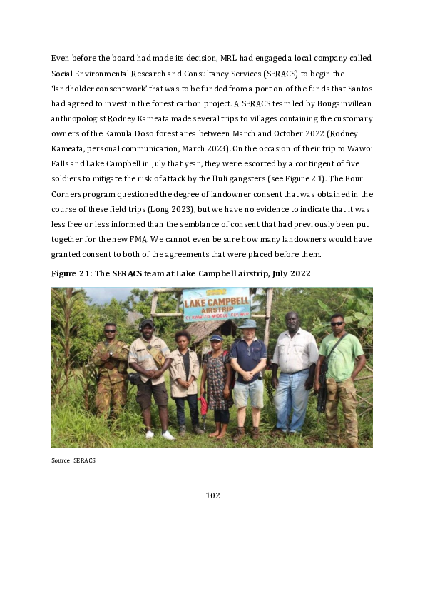
At the end of August 2022, the new forests minister Salio Waipo conceded that the
question of how to regulate forest carbon projects was still ‘floating’ between his own
ministry and the one responsible for climate change (Tarawa 2022), but promised to
deal with the matter through the long-promised amendments to the Forestry Act that
still have not seen the light of day. At the beginning of November, MRL was reassuring
investors that it was still in the business of providing the government and local
landowners with ‘a far superior financial, social, and environmental
alternative/outcome to commercial logging’ (MRL 2022d: 25). Its partnership with
Santos appears to have been renewed or extended at the end of the year (Anon. 2022d).
At that juncture, there were two sides to the legal stalemate. TTDL had challenged the
legality of the new FMA while MRL was challenging the legality of the decision to cancel
the forest carbon permits. The question of landowner consent was being raised in both
cases, but there is as yet no sign of a judicial resolution (Rodney Kameata, personal
communication, June 2023).

6      Conclusion

The project proposals reviewed in this paper vary in the extent to which they satisfy the
four criteria by which forest carbon projects create value in the voluntary carbon
market. If we only consider the project documents submitted to Verra, we must
conclude that those produced by NIHT and KMS have a much lower level of credibility
than those produced by FORCERT, even though they differ in the nature of the errors
they contain. Since the MRL proposal has yet to produce the same kind of document, we
cannot make a similar assessment of its quality.

One of the most notable differences between the NIHT and KMS documents is the way in
which they fail to deal with the criterion of additionality. The KMS documents grossly
exaggerate the threat of deforestation and forest degradation in all three project
locations, while the NIHT documents appear to underestimate this threat, at least in the


                                           103
Konoagil LLG area and the rest of Namatanai District. The KMS documents imagine
threats that simply do not exist and cannot therefore demonstrate that revenues from
the sale of carbon credits will serve to reduce the volume of emissions that would be
generated if these threats were to be realised. The NIHT documents posit another threat
that seems to be exaggerated, which is NIHT’s own plan to log part of the Konoagil LLG
area, but pay no attention whatever to logging operations that are currently responsib le
for the process of deforestation and forest degradation in this same area. The FORCERT
and MRL proposals make a better case for additionality, if the proponents can
demonstrate a capacity to prevent the National Forest Board from granting new logging
concessions, or to reverse an allocation that has already been made, but it is not clear
whether MRL knows how to do this under the terms of the current legislation, and it is
not clear whether FORCERT will actually succeed in its current litigation.

It is hard for any project proponent to make a convincing case for the permanence or
durability of any agreement covering the use of customary land if the agreement is not
legally binding. The length of the ‘crediting period’ claimed by the proponents of f orest
carbon projects submitted to Verra is normally specified as a certain number of
decades, and three decades is the period normally claimed. Since NIHT has
underestimated the threat of logging in the Konoagil LLG area, it is hard to believe that
it will be able to conserve a large area of forest for that length of time by means of
dubious contracts with a minority of local landowners. There is no credibility at all in
the claim made by KMS that it will be able to control the destructive behaviour
attributed to local landowners for a period of 100 years in the absence of anything other
than a program to train some of them to police the behaviour of the rest. FORCERT has a
better claim to the enduring support of those local communities with whom it has taken
the trouble to develop a partnership, but the cost of maintaining such partnerships is
quite substantial.


                                           104
The two KMS proposals do discuss the problem of leakage, but only to the extent of
suggesting that local villagers will intensify their exploitation of native forests in what
are described as the ‘leakage management areas’ surrounding the areas of forest f rom
which carbon credits will be generated. This amounts to little more than a sign of the
proponent’s failure to produce the sort of ‘land use plan’ that figures in the Tavolo
project document. That is because the KMS documents, like the NIHT documents, do not
contain a valid account of the current pattern of land use in their respective project
locations, let alone a valid historical account of the way that this pattern has been
changing over time.

FORCERT is the only project proponent that has so far managed to show that it has a set
of procedures to safeguard the interests of local landowners when making conservation
agreements, although we cannot tell what further steps MRL might take in this
direction. The NIHT proposal recognises the need to secure free, prior and informed
consent for its project, and also the need for an equitable benefit-sharing agreement, but
we are not persuaded that these requirements have been met. The KMS proposals
contain very brief discussions of ‘safeguards’ that merely postulate the absence of any
negative impact on local livelihoods, despite the limits to be placed on local agricultural
practices, and make a thoroughly unconvincing case for the extent of current and fu ture
consultation with local landowners.

Given the flaws we have identified in the NIHT and KMS project documents approved by
Verra, we must now ask whether something could be done to improve the quality of the
validation and verification process whereby forest carbon projects are currently being
certified. When we offered our critical comments on the two KMS project documents in
2022 Verra 2022a, 2022b), we tried to discover the process by which Verra’s own staff
review the quality of the documents submitted by project proponents before posting
them to its website, and how they then respond to the comments received during the
brief period of public consultation. We did not receive any response to our inquiries.


                                            105
In September 2022, Verra did write to inform KMS that it would not be proceeding with
registration of the Oro project because it had ‘failed to demonstrate conformance with
VCS rules or requirements’ (Mukherjee 2022). However, it seems that no steps were
taken to suspend the registration of the second KMS project, which we consider to be
even less credible, and KMS was allowed to resubmit a revised version of its Oro project
document, which is why the Oro project still figures on the Verra website as a project
for which registration is being ‘requested’ (see Table 2). Verra’s staff might argue that
they simply do not have the resources required to assess the quality of all the proposals
that they receive, but then we must ask about the quality of the process by which they
grant accreditation to other entities to function as auditors and validators of the
projects that pass through the certification process. In March this year, Verra
announced a wholesale revision of the way that it certifies forest carbon pr ojects
(Greenfield 2023b), but we have yet to discover what the result will be.

One of our aims in this paper has been to reveal the extent to which different project
documents display a disturbing ignorance of existing sources of data on the way in
which PNG’s native forests are actually being used or exploited and on the way that
members of rural communities relate to the other actors with an interest in forest
management. It might be unreasonable to expect that the proponents of forest carbon
projects, or their various consultants, should examine these sources in the same level of
detail that we have attempted in this paper. But the level of ignorance displayed in the
KMS and NIHT project documents is really not acceptable. Ideally, this situation could
be remedied by a requirement for validators and auditors to demonstrate a certain level
of experience and expertise in the countries they are writing about, and a more
transparent process whereby these entities obtain their accreditation from Verra.

A process of peer review by experts with knowledge of the relevant country could also
be part of the process of certification. Now this would certainly add something to the
cost of validation and verification, but it should also add something to the value of the


                                           106
product that is taken to market. At least it should do so if the market actually cares
about the truth. But maybe this market does not care to discriminate between a cheap
project producing millions of phantom carbon credits and a more expensive but more
reliable project producing a much smaller quantity. Perhaps Verra is prepared to flood
this particular market with cheap forest carbon credits because these add ‘liquidity’ to
the larger carbon market in which other forms of emission reduction can be traded
more efficiently. In which case we have to wonder whether the REDD ‘methodology’
amounts to anything much more than a confidence trick.

The next question is whether our own investigation of forest carbon projects in PNG,
like the Four Corners program and the moratorium imposed by the PNG government,
will help to dampen the current wave of enthusiasm for such investments in the same
way that the previous wave of enthusiasm was made to subside in 2010. In the current
international climate, we do not see how the demand for cheap forest carbon credits is
going to diminish because countries with high levels of emissions have made stronger
commitments to achieve ‘net zero’ under the terms of the Paris Agreement and
subsequent amendments to the UNFCCC. As a result of this demand, we see that dead or
dormant projects in PNG are being resurrected or reawakened under new management,
while new schemes continue to be hatched in anticipation of the moratorium being
lifted.

Just as the Kamula Doso project once conceived by Kirk Roberts has been resurrected
under the auspices of MRL, so does the April Salumei project now seem to be
undergoing a process of resurrection under the auspices of a company called Tasman
Environmental Services, which responded to the Four Corners program by declaring
that the project ‘has been delivering transformative, positive outcomes for climate,
nature and people for almost 13 years’ (TEM 2023). The basis of this claim is unclear. As
we have seen, the original project proposed by a company called Rainforest Project
Management was awarded a VCS certificate in 2013 (see Table 2). At that juncture, it


                                           107
was described as a ‘REDD+ pilot project’ in the draft National Forest Plan produced by
the PNGFA (GPNG 2012). Most of the documents currently contained on the Verra
website date from that early period, although some of them seem to have been ‘updated’
in 2017. When PNG’s Climate Change Act was passed in 2015, the government’s
‘ownership’ of the project was transferred to the CCDA, whose minister was still
promising to allocate more government funding to the project in 2019, but only if the
local landowners would agree on a benefit distribution mechanism (Anon. 2019c).
However, there is no evidence of landowners receiving any benefits at all since 2015. In
February 2023, Verra wrote to the project’s validator, a company called SCS Global
Services, to say that the new process of validation and verification was incomplete, so
the project was to be put ‘on hold’ (Seager 2023). We have not been able to discover the
history of relationships between the corporate entities involved in the promotion of this
project, but Tasman Environmental Services now seems to have positioned itself as the
project proponent and might be expecting to secure government approval for its project
proposal because the government already ‘owns’ the project.

In May 2023, NIHT announced a new partnership with the Namoant ILG and the Morobe
Provincial Government whereby 35 million kina would be invested in a project to
generate carbon credits from the ‘afforestation, reforestation and re -vegetation’ of
46,000 hectares of customary land in the Markham Valley (Anon. 2023c). The project
was to be managed by Robert Strauss, Stephen’s brother. The landowners were
apparently promised 70 kina for each hectare of land on which new trees were to be
planted, plus 10 per cent of the revenue from the sale of the carbon credits. To judge by
the benefit-sharing scheme already adopted in New Ireland, this would be 10 per cent
after deduction of numerous costs incurred by the developer. We have not been able to
discover an application for incorporation from a land group called Namoant, or anything
like it, in the pages of the National Gazette, so we do not know which part of the
Markham Valley it might claim as its own, but NIHT does appear to have a preference
for making agreements with one land group at a time, even if the group in question has

                                           108
no legal personality. We know nothing more about this project than what has been
contained in the press release that informed one newspaper article. The project
proposal has yet to make its way to the Verra website, if that is where it is heading. We
do not know how many other new REDD or REDD+ projects might also be heading in
that direction without being the subject of an article in one of PNG’s national
newspapers.

In August 2023, after a lengthy period of stakeholder consultation, the CCDA finally
published a set of four REDD+ ‘guidelines’ that constitute another milestone in PNG’s
forest carbon policy process (see Table 1). The first of these is a generic set of
‘development guidelines’ (GPNG 2023a) complemented by three more specific
guidelines dealing with the issues of free, prior and informed consent, benefit
distribution and grievance mechanisms (GPNG 2023b, 2023c, 2023d). Their publication
means that the regulatory framework is now almost complete. The only piece of the
jigsaw that remains to be put in place is the Climate Change (Management) (Carbon
Market) Regulation that is meant to complement the amended version of the Climate
Change (Management) Act. We do not propose to discuss the contents of the four
guidelines in any detail since their combined length is more than 200 pages. The
question we need to consider here is whether the publication of these guidelines will
actually serve to change the behaviour of the various actors involved in the validation,
verification and certification of voluntary forest carbon market projects in PNG.

A cursory reading of the guidelines suggests to us that the FORCERT project is the only
one of the projects discussed in this paper that comes anywhere near compliance with
all the rules that they contain. Indeed, some of the rules, like the one that requires all
REDD+ projects to be based on ‘participatory sustainable land use planning’ by
‘customary landholders and local communities’ (GPNG 2023a: 13), appear to reflect the
extensive inputs that FORCERT personnel have made to the guideline production
process. However, FORCERT and other members of PNG’s Environmental Alliance have


                                            109
voiced their concern that publication of the guidelines will simply allow the minister to
lift the moratorium that was imposed in March 2022, and that in turn will provide a
green light for Verra to expedite the certification of projects that do not even p retend to
follow the rules (Lang 2023).

They do have some grounds for concern because some of the project documents
reviewed in this paper made little or no attempt to comply with the national policies
that were already in place when the documents were drafted, and Verra does not
appear to regard such omissions as an obstacle to the process of certification. We also
doubt whether the guidelines, as currently written, will convince Verra and other actors
in the voluntary carbon market to pay more attention to the sources of evidence that we
have used to cast doubt on the validity of some project proposals. But our biggest
concern is that CCDA staff simply lack the capacity to impose this complex set of rules
on the project proponents, which could well mean that they will amount to nothing
more than a giant paper tiger. Put quite simply, we have to wonder whether this
creature will enable the actors in this space to do a better job of understanding or
demonstrating the difference between a project that has genuine community support
and may actually benefit local landowners and a project that is simply designed to
benefit the companies that buy and sell carbon credits. Furthermore, if PNG’s Forestry
Act is amended in such a way as to enable project proponents to bypass the new
guidelines and get their projects approved by the National Forest Board instead, the
paper tiger may prove to be toothless for another reason unless the PNGFA comes up
with an equally complex set of guidelines on its own account.

The signage attached to the latest set of REDD+ guidelines shows that they were
developed with support from the Global Environment Facility, the Green Climate Fund,
the UN Food and Agriculture Organization and the Australian government. The aid
programs of the United States, the European Union and the United Kingdom are now
joining this group of foreign actors with their own plans to improve the management of


                                            110
PNG’s forest resources, but it is not yet clear how much of their investment in this space
will be devoted to the promotion or regulation of forest carbon projects. The Australian
government has declared its own interest in this type of activity by means o f a Joint
Action Plan that was signed by the head of the CCDA and a representative of the
Australian Department of Climate Change, Energy, the Environment and Water in April
2023. This is one of the bilateral partnership agreements that the Australian
government is seeking to establish under the terms of what it calls the lndo -Pacific
Carbon Offsets Scheme. The agreement with the PNG government makes explicit
reference to Article 6 of the Paris Agreement, and makes provision for ‘activities and
demonstration projects’ that will ‘enable the use of carbon offsets for institutional and
other private investors to combine sustainable development in the lndo -Pacific region
with their voluntary corporate emissions targets’ (GPNG and GOA 2023: 1). It also
includes an undertaking to ‘ensure the carbon offsets created meet high standards of
carbon accounting and social and environmental integrity’ (ibid.: 2). Now that PNG’s
own regulatory framework is almost complete, it will be interesting to see what steps
the Australian government and other donor agencies take to improve the way that the
voluntary forest carbon market actually operates in PNG, since its current mode of
operation leaves a great deal to be desired.


                                           111
References

Act Now and Jubilee Australia, 2022. ‘The New Timber Barons: The Companies Logging
the Rainforests of Papua New Guinea.’ Port Moresby and Sydney: Act Now and Jubilee
Australia.

Aenor International, 2020. ‘“The NIHT Topaiyo REDD+ Project” Joint Validation and
Verification Report.’ Madrid: Aenor International for Verra.

Albert, S., 1989. ‘"Kastom i Winim ol Lo"? Development and Political Culture in the Lak
Electorate, New Ireland.’ Research in Melanesia 13: 19–29.

Allen, B. and R.M. Bourke, 2009. ‘People, Land and Environment.’ In R.M. Bourke and T.
Harwood (eds), Food and Agriculture in Papua New Guinea. Canberra: ANU E Press.

Allen, B.J., R.M. Bourke and R.L. Hide, 1995. ‘The Sustainability of Papua New Guinea
Agricultural Systems: The Conceptual Background.’ Global Environmental Change 5:
297–312.

Allen, B.J., R.L. Hide and R.M. Bourke, 2002. Agricultural Systems of Papua New Guinea:
Provincial Text Summaries, Maps, Code Lists and Village Identification (19 Volumes).
Canberra and Port Moresby: Australian National University, PNG Department of
Agriculture and Livestock, and University of Papua New Guinea.

Anon., 2010. ‘Landowners in Oro Province Want Answers.’ Post-Courier, 22 December:

Anon., 2011. ‘Timber Licence Opposed.’ Post-Courier, 27 January:

Anon., 2019a. ‘Landowners Give Land for Development.’ Post-Courier, 26 September:

Anon., 2019b. ‘Police Squad Hunting for Killers in Western.’ The National, 21 November:

Anon., 2019c. ‘Minister Tells Landowners Not to Hinder Project.’ The National, 5 August:

                                          112
Anon., 2020a. ‘Armed Men Kidnap 10, Demand K1.6 Million as Ransom.’ The National,
20 August:

Anon., 2020b. ‘Logging Operations Hit Hard by Covid-19, Workers Laid Off.’ The
National, 4 November:

Anon., 2022a. ‘ILG Ignored Land Boundaries [letter].’ The National, 20 April:

Anon., 2022b. ‘Forest Board Ceases Mayur Renewables’ Carbon Permits.’ The National,
21 July:

Anon., 2022c. ‘Mayur to Challenge Notice.’ The National, 22 July:

Anon., 2022d. ‘Mayur and Santos Extend Arrangement on Carbon Projects.’ The
National, 21 December:

Anon., 2023a. ‘Crime Has Overtaken the Law [editorial].’ The National, 15 June:

Anon., 2023b. ‘Act Now.’ The National, 18 April:

Anon., 2023c. ‘K35mil Project for Markham.’ The National, 31 May:

Avusi, P. and P. Dam, 2020. ‘Benefits from Ecosystem Services from PNG’s Forests for
Communities & the Country.’ In GPNG (Government of Papua New Guinea) (ed.),
Harnessing Inclusive Opportunities and Greater Economic Potential of the Forestry Sector:
Proceedings of the Papua New Guinea Forestry Summit, Port Moresby, 9–11 October 2019.
Boroko: PNG Forest Authority.

Babon, A. and G.Y. Gowae, 2013. ‘The Context of REDD+ in Papua New Guinea: Drivers,
Agents and Institutions.’ Bogor: Center for International Forestry Research (Occasional
Paper 89).


                                          113
Babon, A., C. Filer and B. Allen, 2023. ‘Fictitious Commodities: The Forest Carbon Market
in PNG.’ Devpolicy blog, 9 March:

Babon, A., D. McIntyre, G.Y. Gowae and others, 2014. ‘Advocacy Coalitions, REDD+, and
Forest Governance in Papua New Guinea: How Likely Is Transformational Change?’
Ecology and Society 19: 16.

Bellamy, J.A. and J.R. McAlpine, 1995. Papua New Guinea Inventory of Natural Resources,
Population Distribution and Land Use Handbook. Canberra: Australian Agency for
International Development (PNGRIS Publication 6).

Bird, N., A. Wells, F. van Helden and R. Turia, 2007. ‘The Current Legal and Institutional
Framework of the Forest Sector in Papua New Guinea.’ London: Overseas Development
Institute (Papua New Guinea Forest Studies 2).

Chandler, J., 2023. ‘Ransom Enterprise.’ The Saturday Paper, 4 March:

Chatterton, P., Y. Bun, C. Hunt and others, 2000. A Future for Our Forests: Strategies for
Community-Based Forestry and Conservation in Papua New Guinea. Suva: Worldwide
Fund for Nature.

Dam, P., 2011. ‘Can Carbon Compete with the Loggers in Papua New Guinea?’ In M.
Skutsch (ed.), Community Forest Monitoring for the Carbon Market: Opportunities under
REDD. London: Earthscan.

Dore, D., S.K. Matawe, S. Pesto and A. Baretta, 2019. ‘FORCERT: Organisation Evaluation
Report — November 2019.’ Unpublished report to FORCERT.

ecoPartners (Ecological Carbon Offset Partners), 2018. ‘Request for Proposals: Papua
New Guinea FSC Management Plan and Certification.’ Berkely (CA): ecoPartners.

Ellison, R., 2022. ‘ENB-US Firm in Carbon Deal.’ The National, 6 May:


                                           114
EP Carbon, 2020a. ‘The NIHT Topaiyo REDD+ Project (Version 1.30).’ Berkeley (CA): EP
Carbon for Verra.

EP Carbon, 2020b. ‘The NIHT Topaiyo REDD+ Project (Version 1.55).’ Berkeley (CA): EP
Carbon for Verra.

Ericho, J., R. Nigints and R. Barcham, 2013. ‘External Evaluation.’ Unpublished report to
FORCERT.

Filer, C., 2005. ‘The Conservation Policy Community in Papua New Guinea.’ Canberra:
Australian National University, Research School of Pacific and Asian Studies, Resource
Management in Asia-Pacific Program (RMAP Working Paper 55).

Filer, C., 2011. ‘The Political Construction of a Land Grab in Papua New Guinea.’ Paper
presented at the international conference on ‘Global Land Grabbing’, Institute of
Development Studies (UK), 6–8 April.

Filer, C., 2015. ‘How April Salumei Became the REDD Queen.’ In J.A. Bell, P. West and C.
Filer (eds), Tropical Forests of Oceania: Anthropological Perspectives. Canberra: ANU
Press.

Filer, C., 2019. ‘Two Steps Forward, Two Steps Back: The Mobilisation of Customary
Land in Papua New Guinea.’ Canberra: Australian National University, Crawford School
of Public Policy, Development Policy Centre (Discussion Paper 86).

Filer, C., 2022. ‘Papua New Guinea’s Forests Back in the Spotlight.’ Canberra: Australian
National University, Crawford School of Public Policy, Development Policy Centre
(Discussion Paper 103).

Filer, C. with J. Numapo, 2017. ‘The Political Ramifications of Papua New Guinea’s
Commission of Inquiry.’ In S. McDonnell, M.G. Allen and C. Filer (eds), Kastom, Property,
and Ideology: Land Transformations in Melanesia. Canberra: ANU Press.

                                          115
Filer, C. and M. Wood, 2012. ‘The Creation and Dissolution of Private Property in Forest
Carbon: A Case Study from Papua New Guinea.’ Human Ecology 40: 665–677.

Filer, C., M. Wood and A. Babon, 2023. ‘Timber Barons v Carbon Brokers: The Kamula
Doso Forest Area in Papua New Guinea.’ Devpolicy blog, 4 April:

Filer, C., R.J. Keenan, B.J. Allen and J.R. McAlpine, 2009. ‘Deforestation and Forest
Degradation in Papua New Guinea.’ Annals of Forest Science 66: 813.

Fletcher, L. and S. Kuman, 2020. ‘The Coal Agenda: Mayur Resources and the Push to
Start a Coal Industry in PNG.’ Port Moresby and Sydney: Center for Environmental Law
and Community Rights and Jubilee Australia.

FORCERT (Forests for Certain: Forests for Life), 2021. ‘PNG Communities Best REDD —
Tavolo Project (Version 1.1).’ Kimbe: FORCERT for Verra.

Gabriel, J., P.N. Nelson, C. Filer and M. Wood, 2017. ‘Oil Palm Development and Large -
Scale Land Acquisitions in Papua New Guinea.’ In S. McDonnell, M.G. Allen and C. Filer
(eds), Kastom, Property, and Ideology: Land Transformations in Melanesia. Canberra:
ANU Press.

Gabriel, J. and M. Wood, 2015. ‘The Rimbunan Hijau Group in the Forests of Papua New
Guinea.’ Journal of Pacific History 50: 322–343.

Gavara-Nanu, B.D.S., 2020. Carbon Fraud & Illicit Networks: Risks in REDD+. Adelaide:
Flinders University (Ph.D. thesis).

GPNG (Government of Papua New Guinea), 1993. ‘National Forestry Development
Guidelines.’ Hohola: Ministry of Forests.


                                            116
GPNG (Government of Papua New Guinea), 2000. ‘Mukus Tolo (East New Britain
Province).’ Port Moresby: PNG Independent Forestry Review Team (Individual Project
Review Report 3).

GPNG (Government of Papua New Guinea), 2001a. ‘Ioma Block 5 (Oro Province).’ Port
Moresby: PNG Independent Forestry Review Team (Individual Project Review Report
17).

GPNG (Government of Papua New Guinea), 2001b. ‘Kamula Doso (Western Province).’
Port Moresby: PNG Independent Forestry Review Team (Individual Project Review
Report 16).

GPNG (Government of Papua New Guinea), 2002. Investigation into a Decision of the
National Forest Board to Award Kamula Doso to Wawoi Guavi Timber Company (a
Subsidary of Rimbunan Hijau) as an Extension to the Wawoi Guavi Timber Resource
Permit. Port Moresby: Ombudsman Commission.

GPNG (Government of Papua New Guinea), 2012. ‘National Forest Plan (Draft).’ Port
Moresby: PNG Forest Authority.

GPNG (Government of Papua New Guinea), 2014. ‘Guidelines on FPIC for REDD+ in
Papua New Guinea.’ Port Moresby: Office of Climate Change & Development.

GPNG (Government of Papua New Guinea), 2016. ‘Demarcation of Responsibilities for
Forestry Including REDD & REDD+ Activities between PNG Forest Authority and
Climate Change and Development Authority.’ Port Moresby: Office of the State Solicitor.

GPNG (Government of Papua New Guinea), 2019. Forest and Land Use Change in Papua
New Guinea 2000–2015. Port Moresby: PNG Forest Authority.

GPNG (Government of Papua New Guinea), 2023a. ‘National REDD+ Development
Guidelines.’ Port Moresby: Climate Change and Development Authority.

                                         117
GPNG (Government of Papua New Guinea), 2023b. ‘National REDD+ Free Prior and
Informed Consent Guidelines.’ Port Moresby: Climate Change and Development
Authority.

GPNG (Government of Papua New Guinea), 2023c. ‘National REDD+ Benefit Sharing and
Distribution Guidelines.’ Port Moresby: Climate Change and Development Authority.

GPNG (Government of Papua New Guinea), 2023d. ‘National REDD+ Grievance Redress
Mechanism Guidelines.’ Port Moresby: Climate Change and Development Authority.

GPNG (Government of Papua New Guinea) and GOA (Government of Australia), 2023.
‘Papua New Guinea-Australia Indo-Pacific Carbon Offsets Scheme: Joint Action Plan.’
PNG Climate Change and Development Authority and Australian Department of Climate
Change, Energy, the Environment and Water

Greenfield, P., 2023a. ‘Revealed: More Than 90% of Rainforest Carbon Offsets by Biggest
Certifier Are Worthless, Analysis Shows.’ The Guardian, 19 January:

Greenfield, P., 2023b. ‘Biggest Carbon Credit Certifier to Replace Its Rainforest Offsets
Scheme.’ The Guardian, 11 March:

Hammermaster, E.T. and J.C. Saunders, 1995. Forest Resources and Vegetation Mapping
of Papua New Guinea. Canberra: Australian Agency for International Development
(PNGRIS Publication 4).

Hemming, P. and A. Babon, 2022. ‘Carbon Cowboys and Cattle Ranches: Submission on
the Proposed REDD+ Project on Oro Province of Papua New Guinea.’ Canberra:
Australia Institute.

Hemming, P., R. Campbell and S. Venketasubramian, 2022. ‘State-Sponsored
Greenwash.’ Canberra: Australia Institute.


                                             118
Honey, T., 2021. President’s Report to the Annual General Meeting of the Forest
Industries Association, 1 October.

Howes, S., 2009. ‘Cheap but Not Easy: The Reduction of Greenhouse Gas Emissions from
Deforestation and Forest Degradation in Papua New Guinea.’ Pacific Economic Bulletin
24: 130–143.

Hunt, C., 2002. ‘Local and Global Benefits of Subsidizing Tropical Forest Conservation.’
Environment and Development Economics 7: 325–340.

Keig, G., R.L. Hide, S.M. Cuddy and others, 2019. ‘CSIRO and Land Research in Papua New
Guinea 1950–2000.’ Historical Records of Australian Science 30: 83–111.

Kenneth, G., 2015. ‘Local Firm Plans K400m Palm Oil Investment.’ Post-Courier, 24 April:

Kenneth, G., 2016. ‘Landowners Serve Petition to Tomuriesa.’ Post-Courier, 28 April:

KLRDL (Kakuna-Lote Resource Development Ltd) and Mekar (PNG) Ltd, 2019. ‘Kakuna-
Lote Agro-Forestry & Reforestation Plantation Development Project.’ Unpublished
project proposal.

KMS (Kanaka Management Services Private Ltd), 2021. ‘REDD+ Project in Oro Province
of Papua New Guinea (Version 0.1).’ Bengaluru (India): KMS for Verra.

KMS (Kanaka Management Services Private Ltd), 2022. ‘Integrated REDD+ Project 1 in
Papua New Guinea (Version 1.0).’ Bengaluru: KMS for Verra.

Lang, C., 2020. ‘The Return of the Carbon Cowboys: How NIHT Inc Failed to Get Free,
Prior and Informed Consent for REDD in New Ireland, Papua New Guinea.’ REDD-
Monitor blog, 12 November:


                                          119
Lang, C., 2021. ‘“Illegal Operations by NIHT Inc”: Kamlapar Incorporated Land Group
Writes to Papua New Guinea’s Climate Change & Development Authority and Verra.’
REDD-Monitor blog, 29 June:

Lang, C., 2022a. ‘The Return of the Kamula Doso REDD Project in Papua New Guinea:
This Time Run by Mayur Resources, a Mining Company, and Santos, an Oil and Gas
Company.’ REDD-Monitor blog, 30 June:

Lang, C., 2022b. ‘Papua New Guinea’s Forest Authority Cancels Mayur Resources’
Kamula Doso REDD Project.’ REDD-Monitor blog, 20 July:

Lang, C., 2023. ‘Papua New Guinea Environmental Alliance Letter about the Country’s
Proposed Carbon Market Regulation.’ REDD-Monitor blog, 12 April:

Lima, G., 2020. ‘REDD a Revenue Earner in Pomio.’ The National, 28 October:

Lima, G., 2021. ‘Communities Tap into Carbon Trade.’ Post-Courier, 15 December:

Long, S., 2023. ‘Carbon Colonialism: Can Carbon Credits Really Save the Planet?’ ABC
Four Corners, 13 February:

Luma, D., 2021. ‘Forestry Making Policy Shift.’ The National, 21 October:

Mathew, I., 2021. ‘K6 Million for Carbon Credit Sellers.’ Post-Courier, 28 July:

McAlpine, J. and J. Quigley, 1998. ‘Forest Resources of Papua New Guinea: Summary
Statistics from the Forest Inventory Mapping (FIM) System.’ Coffey MPW Pty Ltd for the
Australian Agency for International Development and the PNG National Forest Service.

McCallum, R. and N. Sekhran, 1997. Race for the Rainforest: Evaluating Lessons from an
Integrated Conservation and Development ‘Experiment’ in New Ireland, Papua New
Guinea. Port Moresby: PNG Biodiversity Conservation and Resource Management
Programme.

                                           120
Melick, D., 2010. ‘Credibility of REDD and Experiences from Papua New Guinea.’
Conservation Biology 24: 359–361.

Mirou, N., 2011. Transcript of SABL Commission of Inquiry Hearing, Kiunga, 23
November.

Mirou, N., 2012. Transcript of SABL Commission of Inquiry Hearing, Waigani, 10
January.

Mirou, N., 2013. Commission of Inquiry into Special Agriculture and Business Lease (C.O.I.
SABL): Report. Port Moresby: Government of Papua New Guinea.

MRL (Mayur Resources Ltd), 2022a. ‘Investor Webinar: Mayur Granted Forest Carbon
Concessions in PNG, Paving Pathway to “Net Zero”.’ Report to Australian Stock
Exchange, 13 January.

MRL (Mayur Resources Ltd), 2022b. ‘Mayur and Santos Execute Expression of Interest
to Pursue the Development of Nature-Based Carbon Offset Projects in PNG.’ Report to
Australian Stock Exchange, 20 June.

MRL (Mayur Resources Ltd), 2022c. ‘Mayur Renewables Strategic Partnership
Conference Call.’ Report to Australian Stock Exchange, 20 June.

MRL (Mayur Resources Ltd), 2022d. ‘A Portfolio of Revenue Ready Projects Supporting
the Global Energy Transition.’ Report to Australian Stock Exchange, 2 November.

Mukherjee, T.B., 2022. ‘Project 2760 VCS — Registration and Verification Approval
Request Not Accepted.’ Letter to project proponents, 29 September.

Nalu, M., 2016. ‘Oil Palm Project in Order.’ The National, 18 April:


                                            121
Pan, C., A. Shrestha, J.L. Innes and others, 2022. ‘Key Challenges and Approaches to
Addressing Barriers in Forest Carbon Offset Projects.’ Journal of Forestry Research 33:
1109–1122.

Philip, M., 2022. ‘District to Benefit from Carbon Project.’ The National, 13 January:

Pouru, K., 2020. ‘Challenges and Opportunities to Implement Downstream Processing in
PNG: A Private Sector Perspective.’ In GPNG (Government of Papua New Guinea) (ed.),
Harnessing Inclusive Opportunities and Greater Economic Potential of the Forestry Sector:
Proceedings of the Papua New Guinea Forestry Summit, Port Moresby, 9–11 October 2019.
Boroko: PNG Forest Authority.

Romm, J., 2023. ‘Are Carbon Offsets Unscalable, Unjust, and Unfixable — and a Threat to
the Paris Climate Agreement?’ Philadelphia: University of Pennsylvania, Center for
Science, Sustainability, and the Media.

Rosenbaum, H., J. Ericho and S. Diave-Nerious, 2010. ‘External Evaluation.’ Unpublished
report to FORCERT.

Salafsky, N., 1997. ‘Eleven Steps for Setting up Community-Based Timber Harvesting
Enterprises: An Overview of IRECDP Experience in New Britain, PNG.’ Kimbe: European
Union.

Saunders, J.C., 1993a. ‘Agricultural Land Use of Papua New Guinea (Map with
Explanatory Notes).’ Canberra: Commonwealth Scientific and Industrial Research
Organisation for Australian International Development Assistance Bureau (PNGRIS
Publication 1).

Saunders, J.C., 1993b. ‘Forest Resources of Papua New Guinea (Map with Explanatory
Notes).’ Canberra: Commonwealth Scientific and Industrial Research Organisation for
Australian International Development Assistance Bureau (PNGRIS Publication 2).


                                           122
Scheyvens, H., 2006. ‘Combating Forest Degradation — Certification as a Driving Force
for Amelioration.’ Kanagawa: Institute for Global Environmental Strategies (Policy Brief
3).

Scheyvens, H., 2009. ‘Forest Management and Product Certification Service (PNG):
Socio-Economic Impact Survey.’ Kanagawa: Institute for Global Environmental
Strategies.

Seager, J., 2023. ‘Project 1122 — VCS Verification Approval Request Denied.’ Letter to
project proponents.

Strauss, S., 2018. ‘NIHT Inc. Business Plan.’ Unpublished document.

Tarawa, H., 2022. ‘Iduhu Urges Clarity on Carbon Trade Policy.’ The National, 1
September:

TEM (Tasman Environmental Services), 2023. ‘Carbon Offsets Are Crucial in Combatting
Climate Change, but Integrity Must Come First.’ Announcement on TEM website, 14
February.

Titus, A., H. Rosenbaum and M.R. Palei, 2007. ‘External Evaluation.’ Unpublished report
to FORCERT.

Trangmar, B.B., D.J. Giltrap, S.J. Burgham and T.J. Savage, 1995. Land Suitability
Assessments for Selected Crops in Papua New Guinea. Canberra: Australian Agency for
International Development (PNGRIS Publication 8).

Turia, R., E. Kaidong, P. Malan and others, 2019. Papua New Guinea Forest Base-Map &
Atlas. Boroko: PNG Forest Authority and Japan International Cooperation Agency.

Van Helden, F. and J. Schneemann, 2000. ‘Cutting Trees to Keep the Forest: An Overview
of Lessons Learned from Community-Based Sustainable Forestry Programs with


                                           123
Emphasis on the Production and Marketing of Timber ‘ Zeist: Interchurch Organization
for Development Cooperation.

Verra, 2020. ‘Comments Received by Verra During the Public Comment Period of the
NIHT Topaiyo REDD+ [Project] (2293).’ Washington (DC): Verra.

Verra, 2022a. ‘Comments Received by Verra During the Public Comment Period of the
REDD+ Project in Oro Province of Papua New Guinea (Project ID 2760).’ Washington
(DC): Verra.

Verra, 2022b. ‘Comments Received by Verra During the Public Comment Period of the
Project ID 3284, Integrated REDD+ Project 1 in Papua New Guinea.’ Washington (DC):
Verra.

Verra, 2023. ‘Technical Review of West et al. 2020 and 2023, Guizar -Coutiño 2022, and
Coverage in Britain’s Guardian.’ Washington (DC): Verra.

Vincent, D. and S. Low, 2000. A Review of Papua New Guinea’s Red Meat Industry.
Canberra: Australian Centre for International Agricultural Research (Monograph 66).

WeAct Pty Ltd, 2022. ‘Conservation of Native Forest in the Biodiversity Hotspot of
Papua New Guinea (Version 2).’ Abbotsford: WeAct for Verra.

Wood, M., 1997. ‘The Makapa Timber Rights Purchase: A Study in Project Failure in the
Post-Barnett Era.’ In C. Filer (ed.), The Political Economy of Forest Management in Papua
New Guinea. London and Boroko: International Institute for Environment and
Development and PNG National Research Institute.

Wood, M., 2015. ‘Representational Excess in Recent Attempts to Acquire Forest Carbon
in the Kamula Doso Area, Western Province, Papua New Guinea.’ In J.A. Bell, P. West and
C. Filer (eds), Tropical Forests of Oceania: Anthropological Perspectives. Canberra: ANU
Press.

                                           124
Woti, N., 2023. ‘Lawlessness in Logging Area, a Worry.’ The National, 14 March:

WWF (Worldwide Fund for Nature) and World Bank, 2000. ‘Cutting Down Trees to Save
the Forests: Strategies for Eco-Forestry and Conservation in Papua New Guinea.’ Port
Moresby: WWF and World Bank.


                                         125