Two steps forward, two steps back: the mobilisation of customary land in Papua New Guinea
Logging companies mentioned in this document:
Concessions mentioned in this document:
     Two steps forward, two steps back:
    the mobilisation of customary land in
            Papua New Guinea
                                    Colin Filer

Abstract

In May 2019, the Minister for Lands convened a National Land Summit in Port
Moresby to review the implementation of the National Land Development
Program over the course of the past decade. Much of the discussion at this meeting
was concerned with the incorporation of customary land groups and the voluntary
registration of their collective land titles under legislation that was passed by the
National Parliament in 2009 but did not take effect until 2012. Participants in the
summit thought that the implementation of this legislation had not proven to be
an effective way of ‘mobilising customary land for development’. This paper seeks
to explain why the new legal and institutional regime has failed to live up to the
expectations of the policymakers who were instrumental in its establishment. An
initial examination of the rationale behind the legislation is followed by an
examination of published evidence relating to its implementation in different
parts of the country, including case studies of areas where the evidence serves to
illuminate the motivations of the actors involved in the process of incorporation
and registration. The paper concludes with some reflections on the lessons to be
learnt from this experiment in policy reform.


                           Discussion Paper 86
                                  December 2019
                             Series ISSN 2206-303X
             Electronic copy available at: https://ssrn.com/abstract=3502585

      Two steps forward, two steps back: the mobilisation of customary
                                land in Papua New Guinea

                                           Colin Filer

          Colin Filer1 is an Honorary Professor at the Crawford School of
          Public Policy, The Australian National University.

          Filer, C. 2019. “Two Steps Forward, Two Steps Back: The Mobilisation of
                  Customary Land in Papua New Guinea”. Development Policy Centre
                  Discussion Paper #86, Crawford School of Public Policy, The
                  Australian National University, Canberra.


          The Development Policy Centre is a research unit at the Crawford
          School of Public Policy, The Australian National University. The
          discussion paper series is intended to facilitate academic and
          policy discussion. Use and dissemination of this discussion paper
          is encouraged; however, reproduced copies may not be used for
          commercial purposes.

          The views expressed in discussion papers are those of the author
          and should not be attributed to any organisation with which the
          author might be affiliated.

           For more information on the Development Policy Centre, visit
                               http://devpolicy.anu.edu.au/


1 This paper is dedicated to the memory of my old friend Lawrence Kalinoe, former head of PNG’s

Constitutional and Law Reform Commission and then Secretary for Justice, who sadly passed
away during the public consultations that led to the 2019 National Land Summit. I thank Jim
Fingleton, Siobhan McDonnell and Jason Roberts for their comments on earlier drafts of this
paper. Other individuals cited in the text have provided bits of information that have enabled me
to get somewhat closer to the truth of what has gone on in particular parts of PNG. None of these
commentators or informants are responsible for any factual errors that remain, let alone for my
interpretation of the evidence.


               Electronic copy available at: https://ssrn.com/abstract=3502585
Contents

1.      Introduction ................................................................................................................................................................. 1

2.      Problems with the old regime............................................................................................................................... 2

3.      The new regime in theory .....................................................................................................................................10

        3.1        Steps in the land group incorporation process ................................................................................................ 11

        3.2        Steps in the title registration process ................................................................................................................... 13

4.      New anomalies in the National Gazette ...........................................................................................................15

5.      An elastic deadline and the shape of novelty ................................................................................................23

6.      The end of the lease-leaseback scheme ..........................................................................................................30

7.      Leaseholders lost and found ................................................................................................................................32

        7.1        Leaseholding land groups in rural areas ............................................................................................................. 32

        7.2        Leaseholding land groups in urban and peri-urban areas.......................................................................... 35

8.      Roselaw and Tubumaga ........................................................................................................................................37

9.      Recycled agro-forestry projects .........................................................................................................................40

        9.1        Vailala Oil Palm Project ................................................................................................................................................ 40

        9.2        Aitape West Integrated Agriculture Project....................................................................................................... 41

        9.3        Urasirk Rural Development Project ....................................................................................................................... 44

10. Unprecedented rural clumps ..............................................................................................................................45

        10.1        Torokina Oil Palm Development Project ............................................................................................................ 46

        10.2        The Lavongai leases ...................................................................................................................................................... 48

        10.3        Lak Kandas Oil Palm Project..................................................................................................................................... 52

        10.4        Idam Siawi Agro-Forestry Project ......................................................................................................................... 54

11. The growth of urban bias ......................................................................................................................................59

        11.1        Land groups under a peri-urban local-level government .......................................................................... 60

        11.2        Land groups under the Poreporena–Napa Napa Development Plan .................................................... 66

        11.3        Ohobidudare transformations ................................................................................................................................. 72

12. Discussion and conclusion ...................................................................................................................................75

13. References ..................................................................................................................................................................85


                                  Electronic copy available at: https://ssrn.com/abstract=3502585
            Two steps forward, two steps back: the mobilisation of customary
                                  land in Papua New Guinea


1.     Introduction

In May 2019, a three-day National Land Summit held in Port Moresby identified 17 issues
relating to the ‘efficient utilisation of customary land for the benefit ... of the customary
landowners’ and adopted a resolution on each one of them. Among these were resolutions
calling for a review of the existing legal and institutional regime that regulates the
processes of land group incorporation and voluntary customary land registration (GPNG
2019). The participants had evidently come to the conclusion that this was not proving to
be an effective way of ‘mobilising customary land for development’.

The current legal and institutional regime is the result of a policy process initiated by a
previous national land summit held in 2005 (GPNG 2007; Yala 2010). Its central feature
is a set of amendments to the Land Groups Incorporation Act 1974 and the Land
Registration Act 1981 that were passed by the National Parliament in 2009 but did not
come into effect until 2012. These amendments created an opportunity for incorporated
land groups (ILGs) to register collective land titles once they had met new standards of
transparency and accountability in the process of incorporation. Groups that had already
been incorporated under the original legislation were given five years in which to
reincorporate themselves under the amended legislation, whether or not they were
seeking to register titles to their land, and were threatened with extinction if they failed
to do so.

During the three years that elapsed between the passage and certification of the new
legislation, the national government established a commission of inquiry into the grant
of what the Land Act of 1996 calls ‘special agricultural and business leases’ (SABLs). This
was part of a separate policy process (Filer 2017), but the topic under investigation was
a peculiar institution that was created to compensate for the inability of incorporated
land groups to register collective land titles under the old legal regime. Although the
government put a stop to the grant of such leases when the inquiry was established in
2011, there remains a good deal of uncertainty about the legal status of the leases that

                                                 1


                   Electronic copy available at: https://ssrn.com/abstract=3502585
had already been granted (Filer and Numapo 2017). Furthermore, the perceived failure
of the new legislation to produce the desired level of ‘land mobilisation’ has caused the
participants in the latest land summit to call for a ‘review [of] the relevance of the SABL
process within the context of the land tenure reforms’ (GPNG 2019).

This paper seeks to explain why the new legal and institutional regime has failed to live
up to the expectations of the policymakers who were instrumental in its establishment.
Section 2 asks why they thought that it would solve the problems inherent in the old
regime and thus create new opportunities and incentives for the ‘mobilisation’ of
customary land. Section 3 then examines the way in which their reasoning was reflected
in the specific provisions of the amended legislation. Section 4 shows how notices
published in the government’s National Gazette since 2013 highlight the failure of the
Department of Lands and Physical Planning to implement some of these provisions.
Section 5 deals with some of the reasons why so many land groups that were
incorporated under the old legal regime have not yet been reincorporated under the new
one, and why the government has therefore extended the window of opportunity that
was meant to close in 2017. Sections 6 to 9 deal with the relationship between the
suspension of the SABL scheme in 2011 and the introduction of the new voluntary
customary land registration scheme in 2012, with a number of case studies used to
illustrate the complexity of this relationship. Sections 10 and 11 then use additional case
study material to illustrate what is known about the motivations of people who have
taken advantage of the opportunities offered by the new legal regime, and how these
motivations might vary between rural and urban areas. The concluding section returns
to the issues posed by the resolutions of the latest national land summit, specifically to
the question of what explains the perceived failure of the policy experiment initiated by
the legislation of 2009 and what, if anything, might now be done to produce a more
successful version of this experiment.

2.     Problems with the old regime

In a sense, the recent amendments made to the Land Groups Incorporation Act and Land
Registration Act do not mark the beginning of a new policy regime but the completion of
a national policy process that began with the recommendations of the Commission of
Inquiry into Land Matters back in 1973 (GPNG 1973; Ward 1983). The original Land


                                               2


                 Electronic copy available at: https://ssrn.com/abstract=3502585
Groups Incorporation Act of 1974 was one of several pieces of legislation that were meant
to implement these recommendations, but it held a central place in the whole package
because incorporated land groups were seen as a prime example of what is meant by the
fifth goal of the National Constitution, which is ‘to achieve development primarily through
the use of Papua New Guinean forms of social, political and economic organisation’
(Fingleton 1982). In this case, the assumption was that all the indigenous citizens of the
newly independent state were members of customary groups that were also ‘land groups’
because they were the collective owners of all customary land, and the custom of each
group was what decided the allocation of use rights to the individual members (Power
2008). The Act did not use words like ‘clan’ or ‘tribe’ to describe these customary groups,
nor did it make any assumption about the nature of the customary rules that they applied
to the allocation of use rights. It simply required that each group should formulate a
constitution before it could be granted legal recognition by the state. The Registrar of
Incorporated Land Groups could require additional information, including a list of the
group’s members, but this was optional. He or she could also refuse to recognise a group
that did not appear to qualify as a ‘customary land-owning group’, but had to provide
reasons for such a decision.

A standard application form was attached to the Act. This could be filled in and signed by
any number of people claiming to be members of the land group, and only had to specify
the name of the group, the local-level government area in which its land was located, and
the identity of the proposed ‘dispute-settlement authority’. The latter could consist of a
number of individuals, or the occupants of specific positions, who were empowered by
the group’s constitution to settle disputes between its members. The constitution also
had to specify the qualifications for membership of the group itself and the body set up
to manage its affairs. The Act outlined a process by which the registrar was obliged to
advertise the existence of each application, circulate copies to interested parties for any
comments or objections, and then advertise a subsequent decision to recognise the group
in question. Once incorporated, a land group could apply to the registrar to change its
constitution, and such applications were to be treated in the same way as applications for
incorporation. A group could also be wound up or dissolved, either at its own request or
on the basis of a recommendation to the registrar from a village court or district court, if
there were problems in the management of its affairs.


                                               3


                 Electronic copy available at: https://ssrn.com/abstract=3502585
Section 1 of the Land Groups Incorporation Act noted that the process of land group
incorporation was not only meant to facilitate the more effective use of customary land
and the resolution of disputes about its ownership, but also to create ‘greater certainty of
title’. The Act made no provision for land groups to register titles to their land because
this additional step was understood to be one that would need a separate piece of
legislation (Bredmeyer 1975). Although the commission of inquiry had recommended
that such a law be drafted, this did not happen. The resulting hole in the legal framework
was filled by a stopgap measure that has come to be known as the ‘lease-leaseback
scheme’. Under this scheme, incorporated land groups could lease their land to the state
so that the state could create a registered title over it and then lease it back to the land
groups themselves, or else to what are known in PNG as ‘landowner companies’, in which
land groups should ideally be the shareholders. This scheme was originally devised in the
late 1970s (Hulme 1983), and was later given formal recognition through a set of
amendments made to the Land Act in 1996 (Filer 2011a).

The primary source of information about the actual incorporation of land groups under
this legal regime consists of a long sequence of ‘notices of lodgement of an application for
recognition as an ILG’ that were published in the National Gazette between 1992 and
2012. These application notices normally assigned a number to each of the land groups
seeking recognition. The highest number known to have been allocated in this way is
17988. One might therefore suppose, as many people do, that a total of almost 18,000
land groups had applied for recognition by 2012. However, this appears to be an
overestimate.

The first application notice was published in October 1992, shortly after the function of
land group recognition was transferred from the Registrar of Companies to the
Department of Lands and Physical Planning. In November 1993, the Registrar of
Incorporated Land Groups published a notice in the National Gazette listing 140 land
groups that had already been granted certificates of recognition, of which 80 had been
recognised before the end of January 1993, and 17 before the end of 1991, without ever
having their application notices gazetted. The numbers assigned to these 80 groups
ranged from 6 to 223, which indicates that 143 numbers had already gone missing, in the
sense of not being ‘owned’ by any recognised group. The one application notice published
at the end of 1992 was followed by 13,576 unique application notices between 1993 and

                                               4


                 Electronic copy available at: https://ssrn.com/abstract=3502585
2012.2 This suggests that a lot more land group numbers went missing during that period,
for reasons that are still unclear (Antonio et al. 2010). Although there are some cases,
within that period, in which certificates of recognition have been issued to land groups
whose applications for incorporation were not gazetted, the number appears to be much
smaller than the number of numbers that were not assigned to any group. I am therefore
inclined to think that the total number of applicants was more likely to be 15,000 than
18,000.
In 2011, the Registrar of Incorporated Land Groups implied that applications for
incorporation were almost invariably successful before he was appointed to the position
in 2010, mainly because they were only advertised in the National Gazette, and not in the
national newspapers that have a much wider circulation (Rogakila 2011). It is not
possible to verify this assertion from evidence contained in the gazette, because
application notices were very rarely followed by notices of recognition until 2011, despite
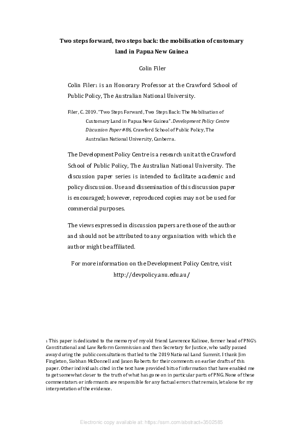
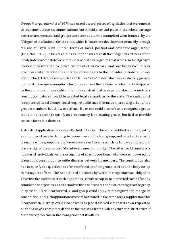
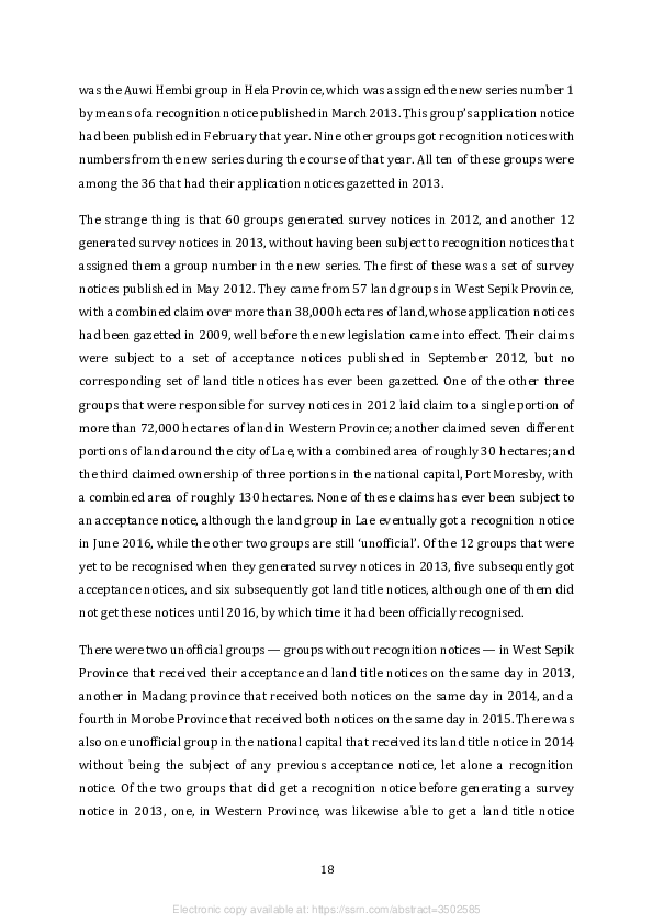
the requirements of the Act. Figure 1 shows that the number of applications that were
gazetted reached a peak in the years between 1995 and 1998, and then peaked again in
the years between 2008 and 2010. To explain this ‘double hump’, we need to consider the
additional sources of evidence that lead to an explanation of the motives behind the
applications. The motives are most easily discovered when several applications were
listed in a single notice, or when multiple applications from the same area were gazetted
on the same day, albeit in separate notices. This kind of ‘clumping’ betrays the presence
of an organiser who is not a member of any of the groups being incorporated yet has a
vested interest in the result.
2 I have discounted a number of cases in which an application notice was accidentally gazetted twice
within a month. However, I have come across some cases, one of which is mentioned towards the end of
this paper, in which the same group seems to have had an application notice gazetted on more than one
occasion at greater intervals of time. I have not been able to eliminate such instances of duplication
from my dataset because I have only recorded the names of the land groups, as well as the number
making applications from particular villages, in a few parts of the country that were selected for more
intensive study.
5
Electronic copy available at: https://ssrn.com/abstract=3502585
Figure 1: Applications for land group incorporation under the old legal regime,
1992–2012
2000
1800
1600
1400
1200
1000
800
600
400
200
0
Source: Author’s calculations based on notices published in the PNG National Gazette, 1992-2012
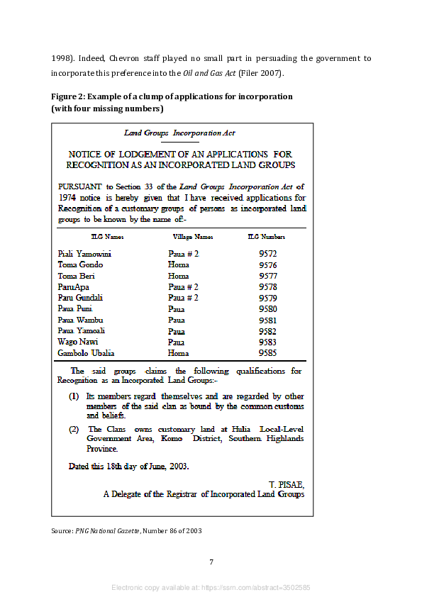
The first organisers to make an appearance in this space were employees of the American
oil company Chevron, which was granted a licence to develop PNG’s first oil export
project in 1990. We now know from company records that they were behind the first
application notice to be gazetted, in October 1992, even though that came from a single
group. They went on to organise 193 applications in 1993, in clumps whose size varied
from two to 70, and were eventually responsible for a total of 480 applications lodged
between 1992 and 2003 (Goldman 2009: 3.37). The first round of applications came from
the Kutubu oil field in Southern Highlands Province and the route of the oil export
pipeline through Gulf Province. The last came from the villages containing the customary
owners of the land on top of the Moran oil field (see Figure 2). Most of these ‘Chevron
groups’ were incorporated before the new Oil and Gas Act was passed in 1998, after
company managers had decided that land group incorporation was the best way to
ensure an equitable distribution of the benefits to which customary landowners were
entitled under the terms of the benefit-sharing agreements made between their
representatives and agents of the state (Power 1996; Taylor and Whimp 1997; Weiner
6
Electronic copy available at: https://ssrn.com/abstract=3502585
1998). Indeed, Chevron staff played no small part in persuading the government to
incorporate this preference into the Oil and Gas Act (Filer 2007).
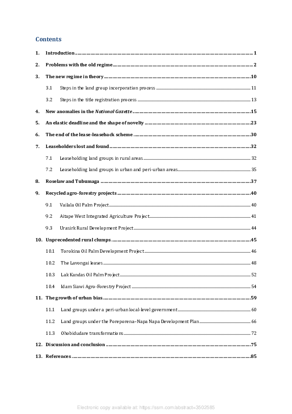
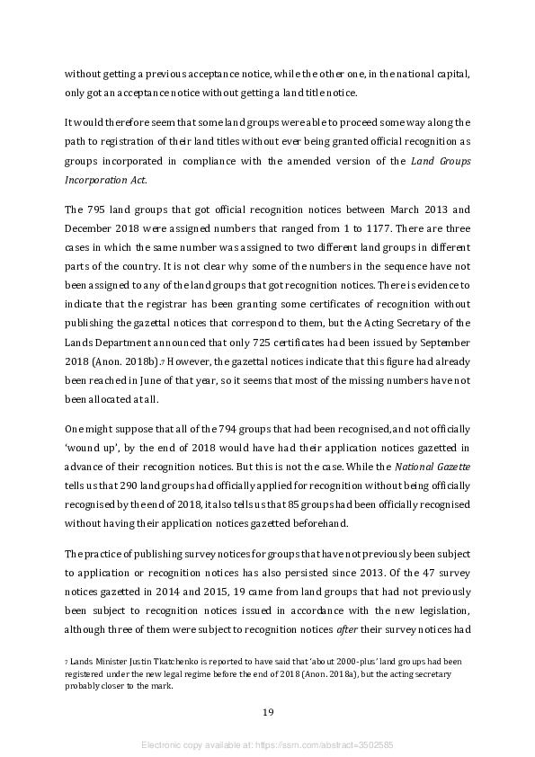
Figure 2: Example of a clump of applications for incorporation
(with four missing numbers)
Source: PNG National Gazette, Number 86 of 2003
7
Electronic copy available at: https://ssrn.com/abstract=3502585
Most of the land group incorporation that took place in the second half of the 1990s had
nothing to do with Chevron, but stemmed from a preference expressed in Section 57 of
the Forestry Act of 1991. This treated the process of incorporation as a mechanism for
securing the free, prior and informed consent of customary landowners to a forest
management agreement (FMA) by which their timber harvesting rights would be
transferred to the state before being allocated to a logging company (Filer 2007). The first
clump of applications associated with this mechanism was a group of 45 from West New
Britain Province in July 1994, but the first of these agreements to be signed was a set of
three that covered the Turama Extension concession in Gulf Province, which is the biggest
single logging concession in PNG. A total of 331 applications from this area were gazetted
between October 1994 and June 1995, nearly all of them towards the end of this period
and some after the agreements had been signed in May that year. Many of the clumps of
applications associated with FMAs are easily identified because the notices in the
National Gazette declare that the relevant clans own land in a designated ‘timber area’ or
‘forest area’, rather than assigning them to a local government area, as is the normal
practice. According to a draft update of the National Forest Plan prepared in 2012 (GPNG
2012), around 5.8 million hectares of land had been covered by FMAs signed between
1995 and 2010, but most of the agreements were signed between 1995 and 1998.3

Officials in the new National Forest Service were trained in the practice of land group
incorporation by consultants working on the Forest Management and Planning Project,
which was funded by the World Bank between 1993 and 1998 as part of the wider
program of forest policy reform (FMPP 1995). One of the consultants previously
responsible for organising the Chevron groups produced a ‘Village Guide to Land Group
Incorporation’ (Power 1995) that recommended the production of property lists,
genealogies, and other forms of evidence that were not formally required by the
legislation, but were meant to convince the registrar that the groups were genuine. Copies
of this manual appear to have circulated beyond the boundaries of areas earmarked for


3 For various reasons, some of the clumps of applications associated with designated ‘timber areas’ or

‘forest areas’ did not lead to FMAs, and even when they did, some of the agreements had been set aside by
2012, either because they had not been properly formulated or because of disputes amongst the
landowners whose groups had been incorporated (Forest Trends 2006; Bird et al. 2007).


                                                    8


                    Electronic copy available at: https://ssrn.com/abstract=3502585

FMAs, and might have been responsible for some clumps of applications that were neither
organised by Chevron staff nor facilitated by forestry officers.

The second peak in the number of applications, between 2008 and 2010, was due to a
rapid increase in the size of the SABLs being granted to landowner companies or their
‘development partners’ under the terms of the lease-leaseback scheme. Public concern
over the scale of this form of alienation is what led to the establishment of the commission
of inquiry in 2011. The commission’s mandate was to investigate 74 of the leases to find
out whether they had been granted with ‘prior consent and approval’ by the customary
landowners (Filer 2017). The commissioners found that such consent had been absent in
most cases, which cast doubt on the authenticity of the land groups through which their
consent had supposedly been secured. However, the policy process that led to the
termination of the lease-leaseback scheme in 2013 had no effect on the policy process
that led to the amendment of the Land Groups Incorporation Act and Land Registration
Act, since the latter process had begun with a land summit convened in 2005 and ended
when the amendments were drafted in 2008, before the lease-leaseback scheme became
a major political issue (GPNG 2007, 2008; Yala 2010).

What initially sparked concern about the proliferation of ‘bogus’ land groups was the
publication of a notice in the National Gazette, in April 1999, ‘dissolving and cancelling’
the registration of 25 of the Chevron groups that had been counted as owners of the land
on top of the Kutubu oil field. It transpired that this was the work of the former governor
of Southern Highlands Province, whose own power base was located in the vicinity of the
oil field, and who was sponsoring the incorporation of another collection of land groups
with a view to diverting part of the benefit stream into his own pocket or the pockets of
his supporters. While Chevron staff managed to persuade the Lands Department to
reinstate the registration of their 25 groups in 2001, the number of alternative land
groups with claims to belong to the project area continued to proliferate. About 550 of
these groups were incorporated between 1993 and 2010. By the end of this period, they
had been joined by as many as 250 groups whose clumping betrayed an intention to claim
landowner benefits from the gas fields that have now been added to the existing oil fields
as components of PNG’s first liquefied natural gas project. To the best of my knowledge,
only eight of these 800 groups was sponsored or organised by the developers (Goldman
2007: 112), so the other organisers are most likely to have been local ‘big men’, possibly

                                               9


                 Electronic copy available at: https://ssrn.com/abstract=3502585
acting in concert with officials from the Department of Petroleum and Energy (Koyama
2004; Weiner 2007).
A second source of concern was an SABL over 50,000 hectares of land that was granted
to the Piu land group in 2001. This area surrounded a prospective mining project in
Morobe Province, and the beneficiaries, who had lodged their application for
incorporation in 1995, were representatives of a single village who were seeking to
exclude other villages from the prospective benefits (Filer 2011a: 274). This case was not
investigated by the subsequent commission of inquiry, partly because the lease had been
granted to a land group rather than a private company, but also because it had already
been the subject of a protracted legal dispute between representatives of the different
villages in the area. By the time of the land summit in 2005, the lease had already been
revoked by the lands minister, his decision had been quashed by the National Court, but
then upheld by the Supreme Court, officers of the Lands Department had been made to
look rather stupid, and the whole contest had been aired at some length in the national
newspapers (Anon. 2004, 2005a, 2005b; Krau 2005). Instead of taking this as a reason to
question the utility of the lease-leaseback scheme, members of the National Land
Development Taskforce took it as evidence of the need to amend the Land Registration
Act so that land groups could get land titles in another way (GPNG 2007).
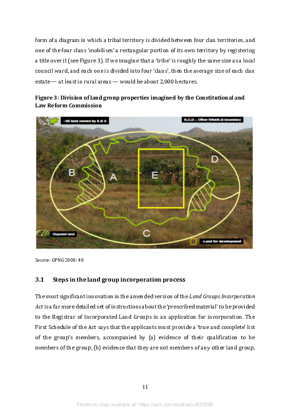
3. The new regime in theory
The primary aim of the new legislation is thus to ensure that each new land group is a
genuine customary group, not some ‘bogus’ group created by ‘paper landowners’, before
it can be granted recognition as a corporate body and then be granted the legal power to
lease some or all of its land to its own members or to other corporate bodies. The thinking
behind the legislation is reminiscent of that which informed the work of the Land Titles
Commission in the 1960s, since it posits a landscape in which ‘tribal territories’ are
divided between the sort of customary groups that old-fashioned anthropologists would
call unilineal (patrilineal or matrilineal) descent groups, and that most Papua New
Guineans simply call ‘clans’. When the head of the Constitutional and Law Reform
Commission was drafting the legislation in 2008, he represented this assumption in the
10
Electronic copy available at: https://ssrn.com/abstract=3502585
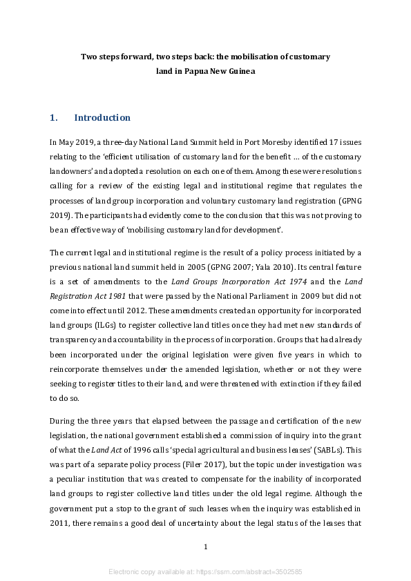
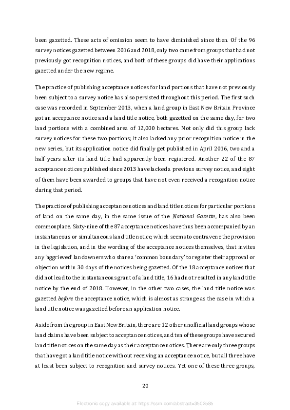
form of a diagram in which a tribal territory is divided between four clan territories, and
one of the four clans ‘mobilises’ a rectangular portion of its own territory by registering
a title over it (see Figure 3). If we imagine that a ‘tribe’ is roughly the same size as a local
council ward, and each one is divided into four ‘clans’, then the average size of each clan
estate — at least in rural areas — would be about 2,000 hectares.

Figure 3: Division of land group properties imagined by the Constitutional and
Law Reform Commission


Source: GPNG 2008: 40


3.1    Steps in the land group incorporation process

The most significant innovation in the amended version of the Land Groups Incorporation
Act is a far more detailed set of instructions about the ‘prescribed material’ to be provided
to the Registrar of Incorporated Land Groups in an application for incorporation. The
First Schedule of the Act says that the applicants must provide a ‘true and complete’ list
of the group’s members, accompanied by (a) evidence of their qualification to be
members of the group, (b) evidence that they are not members of any other land group,


                                                11


                  Electronic copy available at: https://ssrn.com/abstract=3502585
and (c) certified copies of their birth certificates.4 They must also provide a list of the
group’s property, including a description of the land area over which the group claims
customary rights. The Second Schedule says that this must specify the boundaries of the
area in the form of a sketch map, and should include evidence of any boundary disputes
with neighbouring groups (see Figure 3).

If the registrar is satisfied that the application complies with the provisions of the Act,
Section 5 requires that a notice of lodgement of the application be published in the
National Gazette. Copies of this notice must also be sent ‘to the district administrator in
whose area the land group or any of the property claimed on behalf of the land group is
situated’ and to the ‘village court within whose jurisdiction members of the group reside’.
They in turn are required to disseminate the notice ‘in such manner they think most likely
to ensure that it is widely known to person[s] having knowledge of or an interest in the
affairs of the land group or its members’. The applicants should not receive a certificate
of recognition until the registrar knows that this has been done.

The amended Act has not done much to clarify what should be done in the event of
objections being made to the incorporation of a new land group. It makes no reference to
the possible role of village courts or local land courts in dealing with such objections.
Section 5 only deals with those objections that can be construed as ‘internal disputes
relating to the identity of the group’s representatives, officers or membership’. In such
cases, the registrar can either reject the application or do nothing until it appears that the
dispute has been resolved.

The amended Act retains the provisions previously made for land groups to change their
constitutions or to be wound up or dissolved, but it also contains new requirements for
evidence that they are being properly managed. Section 14 requires each land group to
hold a general meeting within three months of registration, and thereafter at intervals of
one year, attended by at least 60 per cent of the group’s members. It also requires the
management committee to notify the registrar of any changes to its own composition and
to provide a statement of the group’s assets and liabilities at regular intervals. Section 28

4 It is not clear how the registrar would know whether individuals were being listed as members of more

than one group in the absence of a database capable of comparing the birth certificates of the members of
different land groups. Even that would not be a reliable source of information if people can obtain more
than one birth certificate under different names.


                                                   12


                    Electronic copy available at: https://ssrn.com/abstract=3502585
allows the registrar to seek additional information about the operation or membership
of each registered land group, and grants any member of the public access to the
information contained in a group’s file.

3.2    Steps in the title registration process

The amended Land Registration Act states that the representatives of a recognised land
group may apply to the Director of Customary Land Registration (‘the director’) to
register their ownership of, or interest in, an area of customary land. There is no
requirement that a land group apply to register all of the land over which it claims
ownership, but nor is there any limit on the proportion of the group’s land that can be
subject to the process of registration.

The requirements of this process are mainly set out in Section 34 of the amended Act.
This says that an application must be accompanied by a ‘registration plan’ that must
include a description of the boundaries of the ‘land or parcels of land’ that are ‘absolutely’
owned by the applicants. The Act does not say what counts as a ‘description’ for this
purpose, but it seems to consist of a combination of two documents that have long been
part of the procedures for the acquisition of customary land by the state — a land
investigation report and a survey plan. These need to be part of a registration plan in
order to produce what Section 34K calls a ‘good root of title’. The application for
registration may also contain, ‘where necessary’, the names of people who are not
members of the group but who still have ‘derivative interests’ in this area of land,
‘including the boundaries of the parcels of such land and the nature of the interest’.

On receipt of the application, the director is required to verify the membership of the land
group and the boundaries of the parcels of land described in the registration plan. This
should entail a meeting with members of the group and a physical inspection of the
boundaries to be undertaken in the company of the group’s ‘appointed representatives’.
This requirement invokes the practice that has been known since colonial times as
‘walking the boundaries’. Once this verification exercise has been completed, the director
is required to produce a version of the registration plan that includes any consequential
revisions or amendments. This is understood to be a further opportunity to include
people who have ‘derivative interests’ in the area.


                                               13


                 Electronic copy available at: https://ssrn.com/abstract=3502585
The director is then required to forward a copy of the registration plan to the Regional
Surveyor and at the same time advertise the existence of the plan ‘in such a manner he
considers appropriate to bring it to the attention of all persons who may have an interest
in the land or parcels of land’ covered by the plan. The regional surveyor would normally
be a suitably qualified officer of the Lands Department based in the province or region
where the land is located. His or her job is to check whether the registration plan includes
any land that is already subject to a title granted by the state, and if so, to produce an
‘adjusted registration plan’ that resolves this inconsistency. The advertisement is meant
to be published in the National Gazette and the national newspapers, just like notices of
applications for land group incorporation. In this case, the notice should inform people
where the registration plan can be examined and how they can make an objection to it
within a period of ‘not more than 90 days’. People objecting to a plan are required to state
whether they do so in a personal capacity or as the representative of a ‘customary group’.

Objections are apparently to be dealt with at the discretion of the director. As in the case
of the amended Land Groups Incorporation Act, the amended Land Registration Act makes
no reference to the possible role of village courts, land mediators or local land courts in
the settlement of disputes between the people making the application and the people
objecting to it. Once the period allowed for objections has expired, and any objections
received during that period have been dealt with, the director is required to prepare a
‘final registration plan’ that forms the basis of advice to the Registrar of Titles to issue a
certificate of title to the land group. The legislation does not seem to require the director
to publish a notice to the effect that this has been done.

Once a land group has been registered as an ‘owner of clan land’, it has the power to grant
‘derivative rights and interests’, typically in the form of leases, to itself, or to any of its
members, or to any other entity. Leases to itself or its members do not seem to require
government approval, but leases to other entities are treated as ‘controlled dealings’,
which means that they need to be registered.

There is no legal mechanism by which the land in question can then be separated from its
collective owner. The land ceases to be subject to ‘customary law’ except insofar as
custom still applies to the transmission of rights to be members of the group holding the
title (Chand 2017). In effect, this means that the group will already have alienated a


                                               14


                 Electronic copy available at: https://ssrn.com/abstract=3502585
portion of its own land to itself, and will thus have become the customary owner of what
is no longer customary land, even if it is still ‘clan land’. At the same time, the customary
group will also have alienated part of its own identity, because the ‘clan’ will have turned
into something that looks and behaves like a miniature version of a private company.

4.      New anomalies in the National Gazette

To assess the manner in which the new legislation has been implemented, I have
compiled a spreadsheet based on information contained in the notices published in the
National Gazette since the legislation came into effect in 2012. There are five main types
of notice, each of which has a distinctive official title that I have abbreviated for the
purpose of the present discussion (see Table 1).

Table 1: Standard notices gazetted under the new legal regime

 FULL TITLE                                                                  ABBREVIATION

 Notice of lodgement of an application for recognition as an ILG             Application notice

 Notice of grant of certification of recognition                             Recognition notice

 Notice of invitation for objection under Section 34G                        Survey notice

 Notice of intention to accept land investigation report                     Acceptance notice

 Notice of registered survey plan                                            Land title notice


Application notices almost invariably identify the name of the proposed land group with
that of the ‘clan’ to which its members are said to belong. They also name the village or
villages where the group’s members are resident and the local-level government (LLG)
area, the district and the province in which they are located. The notices generally include
a list of the vernacular names of the ‘properties’ or land assets claimed by the group, but
the length of this list varies a lot from one notice to another.

Recognition notices assign a number to the group that is about to be recognised. These
notices state that a group has ‘complied with the traditional customs’ of the village
previously named in the application notice, and list the names of the individuals
nominated as members of its management committee and dispute settlement authority.
The management committee is normally said to comprise six individuals — a


                                                        15


                     Electronic copy available at: https://ssrn.com/abstract=3502585

chairperson, deputy chairperson, secretary, treasurer and two female representatives.
The dispute settlement authority is commonly said to comprise three individuals, each of
whom is assigned to a village that may or may not be the same as the village in which the
group is based, and each of whom is also assigned a status such as ‘village elder’, ‘land
mediator’ or ‘village court magistrate’.

Survey notices provide the customary name and estimated area (in hectares) of the land
portion or portions over which a land group is proposing to conduct a ‘land investigation’
and a ‘survey’. These notices invite interested parties to lodge any objections to the
group’s existing ‘sketch’ of this territory within a period of 30 days, and state that copies
of the sketch can be viewed in the offices of the (national) Director of Customary Land
Registration, the Provincial Lands Advisor, or the Regional Surveyor. In some cases, the
notices already assign a number to the proposed survey plan.

Acceptance notices purport to advise ‘customary landowners’ within the relevant LLG
area that the Director of Customary Land Registration is in receipt of a land investigation
report for the portion or portions of land claimed by a land group, and invite any
‘aggrieved’ landowners who share a ‘common boundary’ to register their approval or
objection within a period of 30 days. These notices assign portion numbers as well as
survey plan numbers to the land parcels that have been investigated.

Land title notices state that the Director of Customary Land Registration, in consultation
with the Surveyor General, has accepted the land group’s survey plan as the basis for
registration of its ‘customary land title’ over the land parcels to which portion numbers
have already been assigned in the acceptance notices.

Application notices and recognition notices have occasionally been amended because of
changes in the list of land assets claimed by a land group or changes in the composition
of its management committee or dispute settlement authority. In 2018, there were also
four notices to advise that a land group had been ‘wound up’ because it was found to be


                                               16


                 Electronic copy available at: https://ssrn.com/abstract=3502585
illegitimate, but only one of the four groups had previously been subject to a recognition
notice as well as an application notice. 5

Specific notices are sometimes repeated, presumably by accident, in different issues of
the gazette, but such instances of duplication have been discounted in my calculation of
the number of notices published between 2013 and 2018 (Table 2).

Table 2: Numbers of notices gazetted between 2013 and 2018

 TYPE OF NOTICE                  2013      2014        2015       2016       2017       2018       TOTAL

 Application notices              36         84        116        229        420         126       1,011

 Recognition notices              10         59         61        162        373         130        795

 Survey notices                   14         16         31         16         38         42         157

 Acceptance notices                5         12         6          16         31         17          87

 Land title notices                4         7          4          12         32         16          75


Source: Author’s calculations based on notices published in the PNG National Gazette


Although the Land Groups Incorporation Act of 1974 required the registrar to publish
recognition notices, this did not become standard practice until October 2011.6 The
timing of this innovation seems to be linked to the hearings of the Commission of Inquiry
into SABLs, where Lands Department officials were admonished by the commissioners
when they conceded that previous applications for incorporation had invariably been
approved because no steps had been taken to verify their authenticity. A total of 51
recognition notices were gazetted between October 2011 and the end of February 2012,
immediately before the new Act came into effect. Only two such notices were gazetted in
the remaining ten months of 2012, and another four were gazetted in November 2013,
but all six of the land groups covered by these notices were assigned numbers that
belonged to the old series, so it seems that they were not being recognised under the
terms of the new legislation. The first group to be recognised under the new legal regime


5 Two groups were wound up in light of a local land court decision dating from 2011. A third was found to

be party to a land dispute that was still subject to litigation. The fourth was found to have fabricated a
connection between two different clans from two different villages.
6 In 2018, Lands Minister Justin Tkatchenko said this was the main reason that groups incorporated

under the old regime were ‘non-genuine’ (Anon. 2018a).


                                                     17


                       Electronic copy available at: https://ssrn.com/abstract=3502585

was the Auwi Hembi group in Hela Province, which was assigned the new series number 1
by means of a recognition notice published in March 2013. This group’s application notice
had been published in February that year. Nine other groups got recognition notices with
numbers from the new series during the course of that year. All ten of these groups were
among the 36 that had their application notices gazetted in 2013.

The strange thing is that 60 groups generated survey notices in 2012, and another 12
generated survey notices in 2013, without having been subject to recognition notices that
assigned them a group number in the new series. The first of these was a set of survey
notices published in May 2012. They came from 57 land groups in West Sepik Province,
with a combined claim over more than 38,000 hectares of land, whose application notices
had been gazetted in 2009, well before the new legislation came into effect. Their claims
were subject to a set of acceptance notices published in September 2012, but no
corresponding set of land title notices has ever been gazetted. One of the other three
groups that were responsible for survey notices in 2012 laid claim to a single portion of
more than 72,000 hectares of land in Western Province; another claimed seven different
portions of land around the city of Lae, with a combined area of roughly 30 hectares; and
the third claimed ownership of three portions in the national capital, Port Moresby, with
a combined area of roughly 130 hectares. None of these claims has ever been subject to
an acceptance notice, although the land group in Lae eventually got a recognition notice
in June 2016, while the other two groups are still ‘unofficial’. Of the 12 groups that were
yet to be recognised when they generated survey notices in 2013, five subsequently got
acceptance notices, and six subsequently got land title notices, although one of them did
not get these notices until 2016, by which time it had been officially recognised.

There were two unofficial groups — groups without recognition notices — in West Sepik
Province that received their acceptance and land title notices on the same day in 2013,
another in Madang province that received both notices on the same day in 2014, and a
fourth in Morobe Province that received both notices on the same day in 2015. There was
also one unofficial group in the national capital that received its land title notice in 2014
without being the subject of any previous acceptance notice, let alone a recognition
notice. Of the two groups that did get a recognition notice before generating a survey
notice in 2013, one, in Western Province, was likewise able to get a land title notice


                                               18


                 Electronic copy available at: https://ssrn.com/abstract=3502585
without getting a previous acceptance notice, while the other one, in the national capital,
only got an acceptance notice without getting a land title notice.

It would therefore seem that some land groups were able to proceed some way along the
path to registration of their land titles without ever being granted official recognition as
groups incorporated in compliance with the amended version of the Land Groups
Incorporation Act.

The 795 land groups that got official recognition notices between March 2013 and
December 2018 were assigned numbers that ranged from 1 to 1177. There are three
cases in which the same number was assigned to two different land groups in different
parts of the country. It is not clear why some of the numbers in the sequence have not
been assigned to any of the land groups that got recognition notices. There is evidence to
indicate that the registrar has been granting some certificates of recognition without
publishing the gazettal notices that correspond to them, but the Acting Secretary of the
Lands Department announced that only 725 certificates had been issued by September
2018 (Anon. 2018b).7 However, the gazettal notices indicate that this figure had already
been reached in June of that year, so it seems that most of the missing numbers have not
been allocated at all.

One might suppose that all of the 794 groups that had been recognised, and not officially
‘wound up’, by the end of 2018 would have had their application notices gazetted in
advance of their recognition notices. But this is not the case. While the National Gazette
tells us that 290 land groups had officially applied for recognition without being officially
recognised by the end of 2018, it also tells us that 85 groups had been officially recognised
without having their application notices gazetted beforehand.

The practice of publishing survey notices for groups that have not previously been subject
to application or recognition notices has also persisted since 2013. Of the 47 survey
notices gazetted in 2014 and 2015, 19 came from land groups that had not previously
been subject to recognition notices issued in accordance with the new legislation,
although three of them were subject to recognition notices after their survey notices had

7 Lands Minister Justin Tkatchenko is reported to have said that ‘about 2000-plus’ land groups had been

registered under the new legal regime before the end of 2018 (Anon. 2018a), but the acting secretary
probably closer to the mark.


                                                   19


                   Electronic copy available at: https://ssrn.com/abstract=3502585
been gazetted. These acts of omission seem to have diminished since then. Of the 96
survey notices gazetted between 2016 and 2018, only two came from groups that had not
previously got recognition notices, and both of these groups did have their applications
gazetted under the new regime.

The practice of publishing acceptance notices for land portions that have not previously
been subject to a survey notice has also persisted throughout this period. The first such
case was recorded in September 2013, when a land group in East New Britain Province
got an acceptance notice and a land title notice, both gazetted on the same day, for two
land portions with a combined area of 12,000 hectares. Not only did this group lack
survey notices for these two portions; it also lacked any prior recognition notice in the
new series, but its application notice did finally get published in April 2016, two and a
half years after its land title had apparently been registered. Another 22 of the 87
acceptance notices published since 2013 have lacked a previous survey notice, and eight
of them have been awarded to groups that have not even received a recognition notice
during that period.

The practice of publishing acceptance notices and land title notices for particular portions
of land on the same day, in the same issue of the National Gazette, has also been
commonplace. Sixty-nine of the 87 acceptance notices have thus been accompanied by an
instantaneous or simultaneous land title notice, which seems to contravene the provision
in the legislation, and in the wording of the acceptance notices themselves, that invites
any ‘aggrieved’ landowners who share a ‘common boundary’ to register their approval or
objection within 30 days of the notices being gazetted. Of the 18 acceptance notices that
did not lead to the instantaneous grant of a land title, 16 had not resulted in any land title
notice by the end of 2018. However, in the other two cases, the land title notice was
gazetted before the acceptance notice, which is almost as strange as the case in which a
land title notice was gazetted before an application notice.

Aside from the group in East New Britain, there are 12 other unofficial land groups whose
land claims have been subject to acceptance notices, and ten of these groups have secured
land title notices on the same day as their acceptance notices. There are only three groups
that have got a land title notice without receiving an acceptance notice, but all three have
at least been subject to recognition and survey notices. Yet one of these three groups,


                                               20


                 Electronic copy available at: https://ssrn.com/abstract=3502585
which is based in Morobe Province, had its survey notice and its land title notice
published on the same day in 2017, and that is even more peculiar than the 69 cases in
which land title notices have been published at the same time as the acceptance notices
to which they relate.
Survey notices, acceptance notices and land title notices all specify the area of land to
which they apply, and in cases where the same portion of land has been subject to two or
three of these different notices, the area is normally the same in each of them. There are
four cases in which the area shrank between the survey notice and the land title notice,
two of them with a very substantial reduction, and three in which it grew slightly larger.
The most extreme case of shrinkage is in the size of two land parcels that were each said
to cover 564.6 hectares in the survey notices produced by the Vaga land group from
Kirakira Village in National Capital District in November 2014. When these two land
portions were subject to acceptance and land title notices in April 2017, one had been
confined to 4.79 hectares while the other had shrunk to a mere 0.74 hectares. In such
cases, I have assumed that the most recent notice contains the most accurate measure.
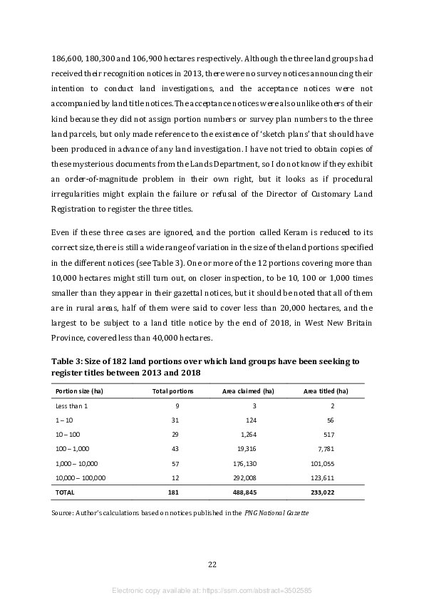
A total of 185 land portions made an appearance in one or more of these three types of
notice between 2013 and 2018, all but one of which was assigned an area. Four of these
land portions were said to be in excess of 100,000 hectares, which seems to be far greater
than the area that could possibly constitute the landed property of a single clan within a
single village (see Figure 3). By far the largest is an area of 529,000 hectares, supposedly
called Keram, that was assigned to the Pukpuk (‘Crocodile’) land group from Lamdo
Village in Madang Province by means of acceptance and land title notices gazetted in
2015. No village of this name can be found in the 2000 national census, but if it really is
located in the Arabaka LLG area, as proclaimed in the group’s recognition notice, then the
whole of that area, or one of equivalent size, would seem to have become the property of
a single clan. However, the scale attached to a copy of the survey plan that I obtained from
the Lands Department reveals that the area is in fact only 529 hectares, even though the
surveyor has written ‘529,000.00’ in the middle of it.
The revelation of this order-of-magnitude problem casts doubt on the real size of three
other land parcels that were assigned to three land groups in Western Province by means
of acceptance notices gazetted on the same day in 2014. These were said to cover
21
Electronic copy available at: https://ssrn.com/abstract=3502585
186,600, 180,300 and 106,900 hectares respectively. Although the three land groups had
received their recognition notices in 2013, there were no survey notices announcing their
intention to conduct land investigations, and the acceptance notices were not
accompanied by land title notices. The acceptance notices were also unlike others of their
kind because they did not assign portion numbers or survey plan numbers to the three
land parcels, but only made reference to the existence of ‘sketch plans’ that should have
been produced in advance of any land investigation. I have not tried to obtain copies of
these mysterious documents from the Lands Department, so I do not know if they exhibit
an order-of-magnitude problem in their own right, but it looks as if procedural
irregularities might explain the failure or refusal of the Director of Customary Land
Registration to register the three titles.

Even if these three cases are ignored, and the portion called Keram is reduced to its
correct size, there is still a wide range of variation in the size of the land portions specified
in the different notices (see Table 3). One or more of the 12 portions covering more than
10,000 hectares might still turn out, on closer inspection, to be 10, 100 or 1,000 times
smaller than they appear in their gazettal notices, but it should be noted that all of them
are in rural areas, half of them were said to cover less than 20,000 hectares, and the
largest to be subject to a land title notice by the end of 2018, in West New Britain
Province, covered less than 40,000 hectares.

Table 3: Size of 182 land portions over which land groups have been seeking to
register titles between 2013 and 2018

 Portion size (ha)               Total portions         Area claimed (ha)         Area titled (ha)

 Less than 1                             9                        3                         2

 1 – 10                                31                      124                         56

 10 – 100                              29                    1,264                        517

 100 – 1,000                           43                   19,316                       7,781

 1,000 – 10,000                        57                  176,130                     101,055

 10,000 – 100,000                      12                  292,008                     123,611

 TOTAL                                181                  488,845                     233,022

Source: Author’s calculations based on notices published in the PNG National Gazette


                                                   22


                     Electronic copy available at: https://ssrn.com/abstract=3502585
5.       An elastic deadline and the shape of novelty

Section 36 of the amended Land Groups Incorporation Act stated that all existing land
groups had to make applications for reincorporation within five years of the Act coming
into effect, otherwise they would ‘cease to exist’. By the time this deadline expired at the
end of February 2017, 540 application notices and 316 recognition notices had been
gazetted in accordance with the terms of the new legislation, so it appeared that
thousands of land groups were on the brink of extinction. However, the registrar
suggested that the National Executive Council might save them from this fate by
extending the deadline (Tarawa 2017a), and Lands Minister Justin Tkatchenko made the
same promise later that year, explaining that ‘the extension was to avoid causing issues
with big industries including oil palm, mining and petroleum to ensure they got the
process right’ (Tarawa 2017b). Section 36 was accordingly amended in November 2018,
giving land groups incorporated under the old regime another five years to rid
themselves of what the minister called their ‘questionable (shadow) legal status’ (Kama
2018).

This invites us to consider the reasons for the difference in the spatial and temporal
distribution of the applications made under the two legal regimes, and hence the
difference between the motivations of the applicants or their corporate sponsors. Since
we already know a good deal about the links between the older groups and a range of
large-scale resource development projects in rural areas, the question is whether the
notices published in the National Gazette since 2013 reveal a similar pattern or one that
is quite different, and if it is quite different, why that should be so. Answers to this
question can only be partial, since none of these notices provides any explicit rationale
for the act of incorporation or the pursuit of a registered land title.

There has never been any systematic process of land group incorporation in the mining
sector, so there has never been a need for mining companies or the relevant government
agencies to ‘get the process right’. Compensation and royalty payments due to the
customary owners of land covered by exploration or development licences in this sector
have been made to ‘agents’ appointed under Section 9 of the Land Act. Although these
individuals may be recognised as ‘clan leaders’, the Mining Act of 1992 says nothing about
the formal incorporation of their customary groups. Less than 50 of the applications


                                               23


                 Electronic copy available at: https://ssrn.com/abstract=3502585
gazetted under the old regime, and less than 20 of those gazetted under the new one,
appear to have come from people claiming customary rights over these mining
concessions. Far from encouraging such applications, company managers and
government regulators have been inclined to view them as a threat to compensation or
benefit-sharing agreements that have already been negotiated. The antics of the Piu land
group in Morobe Province are a case in point (see Section 2).

The situation is quite different in the petroleum sector, because the Oil and Gas Act
expresses a clear preference for land groups, or their executives, to be the recipients of
what the Act calls the ‘royalty benefit’ and ‘equity benefit’ that project area landowners
are entitled to receive from the development of oil and gas projects. However, the Act
does not say who should be responsible for organising their incorporation. It only says
that project proponents or developers are responsible for the conduct of ‘social mapping
and landowner identification studies’ that should help the minister to decide which
groups ought to be incorporated. The situation has been complicated by development of
the PNG LNG Project since 2010, because this project involves a combination of
‘brownfield’ licence areas, from which oil was already being exported, and ‘greenfield’
licence areas, which are new additions to the project. The project’s operator, ExxonMobil,
has never taken responsibility for the incorporation of land groups in any of these areas.
Its joint venture partner, Oil Search Ltd, has belatedly taken some responsibility for
reincorporating the Chevron groups in the brownfield licence areas because it purchased
Chevron’s stake in the oil export business in 2003, and thus inherited the files relating to
the previous incorporation of the 480 ‘Chevron groups’ (John Brooksbank, personal
communication, February 2019). The Department of Petroleum and Energy has taken
responsibility for the process of incorporation in the greenfield licence areas, but its
officers have struggled to convert the findings of social mapping and landowner
identification studies into decisions that are acceptable to a majority of local landowners
(Filer 2019). The Huli-speaking landowners in Hela Province, whose greenfield licence
areas contain most of the gas that is now being exported, have been especially recalcitrant
because they (or their representatives) object to the provision in the new legislation that
prohibits them from being members of more than one land group (Goldman 2007).

By the end of 2018, only two of the original Chevron groups had attempted to
reincorporate themselves. One came from the route of the oil export pipeline, and failed

                                               24


                 Electronic copy available at: https://ssrn.com/abstract=3502585
to achieve a recognition notice. The other came from the Gobe licence area, and did
manage to achieve a recognition notice. This group, which goes by the name of Wolotou,
has been caught up in a protracted legal battle to establish its right to a proportion of the
landowner benefits derived from this area, which probably explains why its leaders want
to reaffirm its legal status. No applications for reincorporation had come from the Kutubu
licence area, which is by far the biggest of the brownfield licence areas. The only
greenfield licence area to show any significant level of activity was the ‘buffer zone’
surrounding the processing plant, just outside the national capital. Although the plant
itself was built on land that had been purchased from its ‘native’ owners back in 1906,
four nearby villages were granted some entitlement to landowner benefits. Nine land
groups from these villages had application notices gazetted between 2015 and 2018, of
which four got recognition notices, and one other group from this area got a recognition
notice without any prior application notice. This last group, called Araua, was the only
one out of the ten to have produced a survey notice, gazetted in 2018, in which it laid
claim to 54,900 hectares of land, which is more than ten times bigger than the portion of
alienated land that contains the plant site. No acceptance or land title notices have
followed this claim, so it is possible that the neighbours lodged an objection to it.

The third industry mentioned in the minister’s pronouncement has developed its own
way of producing benefit-sharing agreements with local landowners, with very little in
the way of state intervention or legal obligation. Between 1997 and 2002, the company
operating a major oil palm scheme in Milne Bay Province organised the incorporation of
33 land groups. New Britain Palm Oil Ltd, which took control of the Milne Bay scheme in
2010, had already been doing something very similar around the Hoskins scheme, in
West New Britain Province, between 1998 and 2009. In both cases, the aim of the exercise
was to extend the boundaries of the nucleus estates that were initially established on land
alienated during the colonial period by persuading local landowners to allocate some of
their customary land to ‘mini-estates’ that would be managed by the palm oil companies.
This was achieved by means of the lease-leaseback scheme. Having arranged the process
of incorporation, consultants engaged by the palm oil companies then arranged for the
land groups to lease their land to the state on condition that it then be leased back to these
same groups and then subleased to the companies, normally for a period of 40 years
(Oliver 2001; Filer 2012a).


                                               25


                 Electronic copy available at: https://ssrn.com/abstract=3502585
A number of financial and institutional considerations would explain the reluctance of
company managers to revisit this process. The original process was time-consuming and
not entirely uncontentious; the legal status of SABLs was thrown into doubt by the
commission of inquiry; the validity of the leases and subleases would be called into
question if existing groups had to be divided into smaller groups in order to comply with
the new legislation; and company managers found it difficult to get relevant advice from
the Lands Department. The recommendations of the latest national land summit seem to
have justified their reluctance. Six of the land groups in West New Britain that were
probably incorporated with company support have since applied for reincorporation
under the new regime, but it is not clear how much company support has been provided
for their reincorporation.

One industry that was not mentioned in the ministerial announcement was the logging
industry. That might seem rather strange, since roughly one-third of the land groups
incorporated under the old legal regime were incorporated for the purpose of negotiating
FMAs, those agreements last for 50 years, and most of them have formed the basis for the
grant of a logging concession that is still operational. However, the Forestry Act was
designed to deny logging companies any role in the process of land group incorporation,
since that process is meant to precede the grant of a concession, and the companies now
have nothing to lose if local land groups cease to exist. Staff of the National Forest Service,
who were actively involved in the process between 1995 and 2010, have not been
directed to revisit and reincorporate as many as 3,000 groups whose chairmen are
currently in receipt of timber royalties from large-scale logging concessions. Nor would
they now have the capacity and resources to undertake such a task. Knowing this to be
the case, they advised the land group chairmen to make their own arrangements and
asked the logging companies to help them do so (Ruth Turia and Andrew Aopo, personal
communications, October 2019).

West Sepik is the only province where these communications had any obvious effect.
Between March 2017 and June 2018, 157 land groups from three LLG areas in Vanimo-
Green District, close to the Indonesian border, were listed in clumps of application notices
published in nine different issues of the National Gazette. It turns out that these groups
contained the customary owners of a selective logging concession called Amanab Blocks
1–4 and Imonda Consolidated, which covers more than 250,00 hectares of forested land

                                               26


                 Electronic copy available at: https://ssrn.com/abstract=3502585
and is held by Amanab Forest Products Ltd.8 Logging company staff are known to have
facilitated the engagement of provincial forestry and lands officers in the process of
reincorporation. The odd thing is that the names of the new groups associated with this
concession bear almost no relationship to the names of the groups whose representatives
had previously signed up to the three FMAs on which it is based. The only explanation for
this discrepancy that I have been able to obtain from people involved in the latest process
of incorporation is that the first process created a large number of ‘bogus’ groups (Jim
Silu and Jack Desse, personal communications, October 2019). It is also conceivable that
land groups or ‘clans’ in this part of the country have very unstable identities, so the
current groups may turn out to be no more durable than their predecessors.

It is not clear why land group chairmen and logging company managers in other FMA
areas have failed to act on the advice provided by officers of the National Forest Service,
but the action taken in this part of West Sepik Province largely explains why this one
province accounts for almost one quarter of all the applications gazetted under the new
regime (see Table 4 and Figure 4). At the same time, the failure to reincorporate groups
formerly registered with the assistance of Chevron staff or forestry officers in other parts
of the country also serves to explain much of the change in the distribution of land groups
between provinces under the two legal regimes, especially the marked decline in the
proportion of groups incorporated in Gulf and Southern Highlands provinces.

The disparities are even greater at the district level. More than 80 per cent of the newly
incorporated groups in West Sepik Province are based in Vanimo-Green District, while
two of the other three districts in this province account for less than 4 per cent. In Kikori
District, one of two districts in Gulf Province, more than 1,600 land groups were
incorporated between 1993 and 2012, but only 11 applied for incorporation between
2013 and 2018, and six of these were new groups staking claims over land that might be
required for PNG’s second gas project. If all the customary landowners of Kikori District
had joined one and only one land group under the old regime, which is rather unlikely,
then 2000 census data suggest that each one would have contained only 24 members —
men, women and children. Indeed, an anthropologist working in that part of the country


8 This company is a subsidiary of the Malaysian conglomerate WTK Realty, which has been based in

Vanimo for more than 40 years and has operated a number of other logging concessions in West Sepik
Province.


                                                 27


                   Electronic copy available at: https://ssrn.com/abstract=3502585
has recorded what seems like a local obsession with the process of incorporation that
may have been initiated by the activities of Chevron staff and forestry officers, but then
seems to have gained a momentum of its own as local people came to believe that
incorporation was a necessary condition of ‘development’ (Bell 2009). Reincorporation
under the new regime does not seem so attractive.

Table 4: Spatial distribution (per cent) of application notices under the old and
new legal regimes

 Region                                       Old regime (1993–2012)        New regime (2013–2018)

 Western Province                                      7.5                               3.3

 Gulf Province                                         13.6                              2.9

 Central Province                                      6.1                               7.7

 National Capital District                             0.5                               5.6

 Milne Bay Province                                    1.7                               1.6

 Oro Province                                          4.2                               2.5

 Southern Highlands Province                           9.4                               1.4

 Hela Province                                         5.7                               3.6

 Enga Province                                         1.0                               0.5

 Western Highlands Province                            0.6                               1.8

 Jiwaka Province                                       0.1                               0.2

 Chimbu Province                                       0.1                               0.4

 Eastern Highlands Province                            1.1                               2.7

 Morobe Province                                       4.8                               5.6

 Madang Province                                       8.2                               5.1

 East Sepik Province                                   6.9                               5.4

 West Sepik Province                                   13.6                              23.8

 Manus Province                                        0.1                               0.3

 New Ireland Province                                  3.3                               5.2

 East New Britain Province                             6.0                               10.5

 West New Britain Province                             5.5                               8.7

 Bougainville Autonomous Region                        0.1                               1.1

Source: Author’s calculations based on notices published in the PNG National Gazette


                                                     28


                       Electronic copy available at: https://ssrn.com/abstract=3502585
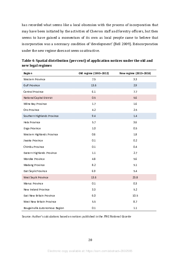
Figure 4: Provinces of Papua New Guinea, 2013


Source: Australian National University


At the other end of the spectrum, there were 21 districts — almost one quarter of all the
districts outside the national capital — in which the number of groups incorporated
under the old regime was less than ten, and four districts in which there were none at all.
None of the districts with such very low levels of incorporation contained a major
resource project, logging concession or oil palm scheme. And since none of them has so
far acquired such a thing, it is not surprising that rates of land group incorporation have
remained very low under the new regime as well. There have only been 40 land groups
from all 21 districts with an application or recognition notice gazetted since 2013, and
the number of districts without a single notice has now risen to six. What still needs to be
explained is the continuing popularity of land group incorporation in some parts of the
country, aside from Vanimo-Green District, and its growing popularity in others,
especially National Capital District (see Table 4).


                                                 29


                   Electronic copy available at: https://ssrn.com/abstract=3502585
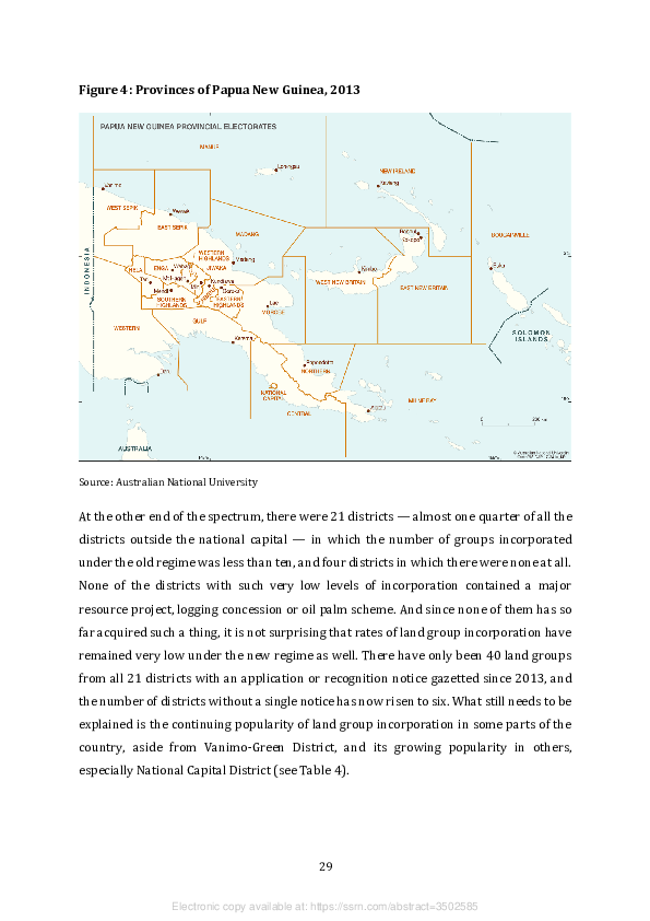
6.     The end of the lease-leaseback scheme

As we have seen, one of the industries that the lands minister accused of dragging its feet
in the process of reincorporation was one that had previously arranged the incorporation
of land groups for the purpose of engaging them in the lease-leaseback scheme, and not
just for the purpose of consenting to the grant of a development licence or the negotiation
of a benefit-sharing agreement. That was the palm oil industry. But established palm oil
producers accounted for a very small proportion of the SABLs issued under this scheme,
and were only implicated in one of the SABLs investigated by the commission of inquiry
in 2011. So what has become of all the other land groups that got mixed up in this scheme
in one way or another? In order to deal with this question, we first need to appreciate the
variation in the size of the leases that ended up in the hands of land groups or other
entities before the national government suspended the scheme.

Notices published in the National Gazette indicate that 981 SABLs were issued by the
Lands Department after amendments to the Land Act created a legal obligation to publish
them (see Table 5). The majority of these leases were apparently issued to individuals or
families, while most of the rest were either issued to private companies or to land groups.
The Act does not actually require that the ‘head lease’ (to the state) be granted by a land
group; it only requires the consent of the customary owners. Many of the SABLs issued to
individuals or families may therefore have been based on nothing more than the
‘verification of ownership and consent of landowner’ forms routinely used in the Lands
Department, which only require the signatures of clan members and the counter-
signatures of village court magistrates or land mediators. However, SABLs issued to land
groups were normally, and understandably, based on head leases granted by these same
groups, and the commission of inquiry found that this type of head lease was also the
foundation for most of the SABLs granted to private companies. The commission of
inquiry did not elicit the names of all the land groups that had supposedly agreed to the
74 SABLs that it investigated, but it did investigate all of the SABLs issued to private
companies that covered areas of more than 10,000 hectares. In most of these cases, it is
possible to identify a clump of land group application notices in the National Gazette that
is clearly connected to the subsequent grant of an SABL in the same approximate location,
and we can therefore check to see if the land groups incorporated for this purpose have


                                               30


                 Electronic copy available at: https://ssrn.com/abstract=3502585
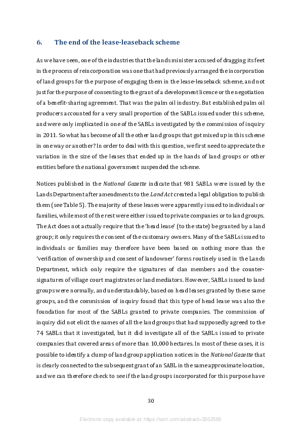
since been reincorporated under the new legal regime. The commission did not
investigate any of the SABLs issued to land groups, but since we already know the names
of the groups to which they were issued, it is easy to see whether these groups have taken
steps to reassert their corporate identity.

Table 5: Special agricultural and business leases gazetted between 1997 and 2012

                                   Leases to       Leases to land     Leases to         Area covered by all
 Scale of lease (hectares)
                                  companies           groups           others                 leases

 More than 100,000                    15                 0                0                4,325,350

 10,000 – 100,000                     31                 11               0                1,192,666

 1,000 – 10,000                       14                 16               0                114,497

 100 – 1,000                          10                 25               3                 11,910

 10 – 100                             15                 16               23                 1,766

 1 – 10                               10                 20               85                  392

 Less than 1                          13                 165             129                  78

 Area not specified                   59                 39              282

 TOTAL                               167                 292             522              > 5,646,659

Source: Author’s calculations based on notices published in the PNG National Gazette


In all these cases, the possible motivations for reincorporation have been complicated by
the national government’s response to the findings of the commission of inquiry. In June
2014, the National Executive Council resolved to implement the recommendations made
by two of the commissioners, John Numapo and Nicholas Mirou, that most of the 49 SABLs
discussed in their final reports should be revoked or reviewed. There were no
recommendations from the third commissioner, Alois JerewaI, because he failed to
produce a final report, so the 25 leases on which he held hearings in Gulf, East New Britain
and West New Britain provinces survived by default. This omission was dealt with by
means of an additional resolution to establish a ministerial committee to make
recommendations on what should be done with these 25 leases and some or all of the
other SABLs that had not even been investigated by the commission (Filer and Numapo
2017: 265–7).


                                                    31


                      Electronic copy available at: https://ssrn.com/abstract=3502585
It is not clear whether the revocation of SABLs, either by the judicial or executive arms of
the state, entails the automatic cancellation of the head leases on which they are based,
and therefore whether the customary owners of the land in question are then free to
pursue the registration of their collective land titles under the new legal regime. At the
same time, the resolutions of the National Executive Council have been subject to a
number of legal challenges, while the ministerial committee seems to have been
overwhelmed by the scale of its mandate, so no further decisions have been made about
the validity of more than 900 SABLs that have not yet been revoked by the courts.

7.     Leaseholders lost and found

One might suppose that land groups holding SABLs in their own right would have the
strongest incentive to reincorporate themselves, since the termination of their legal
identity would remove their capacity to engage in any legal land transactions. Although
the National Gazette tells us that 292 SABLs were issued to land groups after the Land Act
was amended to incorporate the lease-leaseback scheme in 1996, only 122 land groups
were in receipt of them because some land groups got more than one lease. Only 24 (or
20 per cent) of these groups have attempted to reincorporate themselves under the new
legal regime, and they would account for less than 5 per cent of the land groups that have
been the subject of application or recognition notices since 2013.

7.1    Leaseholding land groups in rural areas

Of the six groups associated with the Hoskins oil palm scheme in West New Britain
Province, five have got recognition notices, although one of them seems to have split up
in the process, and only one of its component parts has been recognised. The SABLs
issued to these six groups covered a combined area of approximately 12,000 hectares.
Only one of them, the Maleu group, has so far made an effort to register a collective land
title. In 1999, this group received an SABL covering 778 hectares, but this had been
reduced to 644 hectares in the acceptance notice published in 2018, and that was not
accompanied by a simultaneous land title notice. Another group from West New Britain,
by the name of Lokang, which appears to be based in the Rottock Bay logging concession,
did much better. In 2008, this group received two SABLs with a combined area of
132 hectares, but in 2016, it got an acceptance notice and a land title notice, both


                                               32


                 Electronic copy available at: https://ssrn.com/abstract=3502585
published on the same day, for an area of no less than 39,797 hectares. Nothing more is
known about this group’s activities or motivations.9

More is known about the three groups from East New Britain Province, which are
associated with a new generation of oil palm schemes. Two of them, Simbali and Tomoip,
are associated with the Illi-Wawas Integrated Rural Development Project in Pomio
District. In 2007, this became the first of PNG’s ‘agro-forestry’ projects to be granted a
‘forest clearing authority’ (FCA) by the National Forest Board, thus enabling the
developer, Malaysian company Tzen Niugini Ltd, to fund the establishment of an oil palm
scheme from the revenues generated by clearing the native forest and exporting some of
the logs (Tammisto 2016; Gabriel et al. 2017; Hambloch 2018). The two land groups are
both named after the language or dialect spoken by the people living in one part of the
project area. The Simbali group received an SABL covering 24,810 hectares in 2008, and
proceeded to issue a sublease to Tzen Niugini, thus providing a form of retrospective
consent for their land to be logged (Hambloch 2018: 17). The Tomoip group received two
SABLs over a combined area of 9,472 hectares in 2011. This area does not seem to have
been covered by an FCA, either before or since, although it was certainly part of the larger
scheme. Both groups applied for reincorporation in 2017, but only the Simbali group got
a recognition notice. Neither group has taken steps to register a title under the new
regime.

The Kairak land group seems to have bestowed its own name, which is also the name of
a language, on the Kairak Oil Palm Development Project in the Inland Baining LLG area in
Gazelle District. The group’s ‘development partner’, East New Britain Palm Oil Ltd, has
the same directors as Tzen Niugini, and the two companies have made no attempt to hide
their close relationship (Apina 2012). Although the developer began planting oil palm in
2012, it has not been granted an FCA and has not exported any logs, so this does not
appear to qualify as an agro-forestry project. The Kairak group first applied for
incorporation in 2010, under the terms of the original Land Groups Incorporation Act, but
some of its executives had previously registered a landowner company called Kairak
Investment Ltd back in 1989. The group received two SABLs, with a combined area of


9 The Rottock Bay Consolidated FMA covers a gross area of more than 136,000 hectares. The Lokang

group may have been reincorporated in order to receive and distribute timber royalties from part of this
concession, but it would not be necessary to register a collective land title for this purpose.


                                                   33


                   Electronic copy available at: https://ssrn.com/abstract=3502585
34,536 hectares, in 2011, and initially dedicated one of the two portions, with an area of
10,980 hectares, to the oil palm scheme. In 2016, representatives of three other land
groups in the same area, along with the LLG president and a couple of other clan leaders,
persuaded the National Court to revoke the SABLs on the grounds that the Kairak ‘clan’
was not the sole owner of the two portions and some of the other customary landowners
had not been consulted about the leasing arrangement (PNGNC 2016). Shortly
afterwards, the Kairak group applied for reincorporation, and it received a recognition
notice some months later, but its leaders have not attempted to register a collective land
title. The court order does not seem to have made any difference to the development of
the oil palm scheme, which received a public endorsement from both national and
provincial government representatives in 2017 (Yafoi 2017).

There are also three groups from Morobe Province that received SABLs and have since
sought reincorporation under the new legal regime. One of these is the Piu land group,
whose chairman, Martin Tapei, has never accepted the national government’s refusal to
recognise his status as the ‘principal landowner’ of the Wafi-Golpu mining prospect. He
submitted an application for reincorporation in 2017 and received a recognition notice
the following year. In 2018, the Wafi-Golpu Joint Venture submitted a development
proposal to the national government, which prompted the mining minister to initiate the
negotiation of a benefit-sharing agreement under the terms of the Mining Act. Mr Tapei
was not one of the local landowner representatives invited to participate in this process,
since the mining companies and the Mineral Resources Authority have never accepted
the legitimacy of his claims over the prospect. While he and his supporters protested
through the pages of the national newspapers in the first few months of 2019, as
negotiations were still proceeding, there was no sign that government ministers or
officials were going to change their minds.

Like the Piu land group, the Katumani Dandow group is based in the Mumeng LLG area
and claims to own a considerable part of it. In 2005, this group secured an SABL that
covered 22,000 hectares and lasted for 50 years, but in 2010 a second notice in the
National Gazette extended the period of the lease to the maximum of 99 years. The group
is reported to have subleased the land to PNG Forest Products Ltd, which manages the
country’s largest timber plantation (on state-owned land), so that the company could
build a hydro-electric power station (Nalu 2013). The group applied for reincorporation

                                               34


                 Electronic copy available at: https://ssrn.com/abstract=3502585

in 2016 and got its recognition notice in 2017. However, a man was subsequently
arrested and charged with ‘one count each of false pretence and forgery’ for conspiring
with provincial lands officers to misappropriate the group’s certificate and then
pretending to be its chairman (Kalebe 2017). It is not known whether he was convicted
of this offence or whether he was able to obtain a share of the rent payable for the
sublease.

7.2    Leaseholding land groups in urban and peri-urban areas

The Orognaron group is one of the few land groups to have exchanged its SABL for a
collective land title. The SABL covered 860 hectares and was issued in 2009, while the
land title covered 862 hectares and was issued in 2016. The same group had a survey
notice covering an additional 196 hectares, also published in 2016, but this was not
followed by acceptance or land title notices. The land covered by the lease and the title is
apparently located in the vicinity of Nadzab Airport, and the group’s leaders have been
hoping to sublease it to the developers of an airport township that is featured in the
Morobe Provincial Government’s development plan for the corridor linking the airport to
the city of Lae (Anon. 2016a). It was later reported that 200 hectares of the group’s land
had been earmarked for the construction of an ‘industrial park’ near the airport (Anon.
2018c).

This is not the only land group with an interest in urban development plans. The Modewa
Silabe group in Milne Bay Province got three SABLs, with a combined area of less than
20 hectares, in 2008, and then exchanged one of these leases for 59 much smaller leases,
with a combined area of just over 5 hectares, in 2010. The explanation for this behaviour
is that the group’s leaders were attempting to create a new housing estate on the outskirts
of the provincial capital, Alotau, so they thought it would be a good idea to subdivide the
land into small plots on which the houses could be built. Unfortunately, they forgot to
make provision for the additional infrastructure, such as road access, that would be
required for such a development (Brian Aldrich, personal communication, August 2013).
The group successfully applied for reincorporation in 2017, but there is nothing in the
National Gazette to indicate that it has made any further progress with its plans.


                                               35


                 Electronic copy available at: https://ssrn.com/abstract=3502585

There are five land groups in the national capital that obtained SABLs over one or more
portions of their customary land and have since applied to be reincorporated under the
new legal regime, but only three of them have got a recognition notice. Two of these three,
Uhadi Iarogaha and Uraranu, have also got survey notices published in the National
Gazette, but they do not relate to the land portions already covered by the SABLs, nor
have they been followed by acceptance or land title notices, nor is there any other
documentary evidence relating to the purpose for which the groups have sought to
establish their land claims.

More is known about the Vaga land group, which got an SABL over 9.44 hectares in 2010,
and seems to have subleased this land to the government for the expansion of an existing
sewerage treatment plant in 2014 (Anon. 2014a). By the time this deal was made public,
the group had already had its application and recognition notices published (on the same
day), and had also submitted the two survey notices in which it claimed ownership of two
land portions that were each said to cover 564.6 hectares. The same customary name,
Varahe, was assigned to both portions, which suggests that they were contiguous, and
since the name of the portion covered by the SABL was given as Ogoniva Varahe, one
might suppose that the lease covered one relatively small part of a much larger area of
customary land. However, this assumption was challenged when the group got eight
acceptance and land title notices that were all published on the same day in 2017. Two of
these notices related to the Varahe portions but, as previously noted, their combined area
had now been reduced to a mere 5.53 hectares, which is smaller than the area covered by
the SABL. In contrast, the other six land title notices, which had not been preceded by any
survey notices, covered a combined area of more than 188 hectares, so the total extent of
the group’s registered territory was now about 194 hectares.

To make more sense of this sequence of notices, we need to bear in mind that the Vaga
land group represents one of three ‘clans’ based in Kirakira Village, in the heart of the
national capital, whose leaders supposedly agreed to allocate 400 hectares of their
customary land to a new housing scheme known as the Taurama Valley Pilot Project,
which was sponsored by the national government’s Office of Urbanisation. In 2010, the
head of this agency lamented that the area in question was turning into a ‘haphazard
informal settlement’ because the customary owners were informally selling parts of it to
migrants from other parts of the country before government officials could formalise an

                                               36


                 Electronic copy available at: https://ssrn.com/abstract=3502585

agreement with the three land groups and get the land properly surveyed and subdivided
(Elapa 2010). In a recent letter to one of the national newspapers, he concluded that ‘a
serious attempt to register the whole of the land under the new Voluntary Customary
Land Registration system’ had failed because ‘land ownership and control is vested in
families within the clan or tribal boundaries, not the divided and uncohesive clans and
tribes which have been falsely thought to have the power’ (Kep 2018). The leaders of the
Vaga group may therefore have been seeking to sustain their collective power by
participating in the system that is said to have failed, although it is hard to tell whether
the registration of their group titles has had the desired effect.

8.      Roselaw and Tubumaga

To judge by the names of the recipients and the size of the leases advertised in the
National Gazette, as many as 50 of the 167 SABLs issued to private companies after 1996
could have been in urban or peri-urban areas, but we know nothing about the land groups
that might have consented to most of these leases because they were not investigated by
the commission of inquiry, nor have they been subject to any other form of publicity. Only
three of the 74 leases that were investigated were in urban or peri-urban areas, that is to
say, within or close to the boundaries of the national capital or an urban LLG area. The
first one was issued in 2005 to a company called Roselaw Ltd, which was based in the
national capital. The other two were issued in 2010 to a pair of related landowner
companies, Konekaru Holdings Ltd and Veadi Holdings Ltd, that were looking to
participate in construction of the PNG LNG Project processing plant in Central Province.
The commission recommended that all three leases be revoked because the customary
owners of the land had not been properly consulted (Numapo 2013: 51–68, 158–74).

Only two of the nine clans or land groups that supposedly consented to the leases around
the plant site have since applied for reincorporation, and neither has since taken steps to
register a collective land title. But the Tubumaga land group that supposedly consented
to the Roselaw lease managed to obtain an acceptance notice in 2015, despite the lack of
a previous survey notice, and without any subsequent land title notice, over an area that
included the land previously covered by the SABL.10 This was evidently part of a strategy


10 The Tubumaga group is reported to have received its title over the whole peninsula in September 2015

(Anon. 2015a), but I have not been able to find the corresponding notice in the National Gazette.


                                                    37


                    Electronic copy available at: https://ssrn.com/abstract=3502585
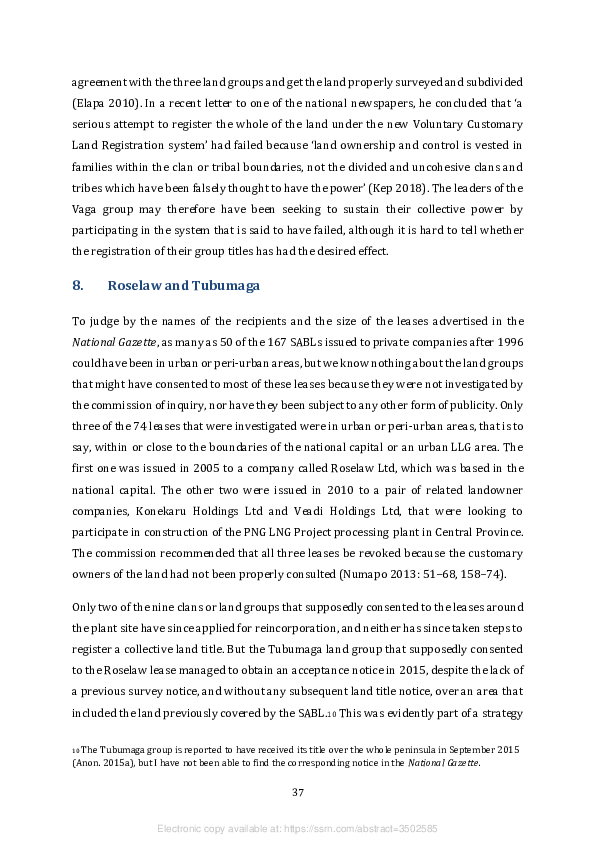
to pursue the previous plan to sublease the land in question for the development of what
has been called a ‘multi-purpose marine facility’ (Numapo 2013: 56).

The land in question is a peninsula, sometimes known as Idumava Point, which lies
opposite the island and village of Tatana, where the Tubumaga group is domiciled, at the
entrance to Port Moresby’s Fairfax Harbour (see Figure 5). The SABL issued to Roselaw
was said to have covered a portion of land whose customary name was Iduvaivai, with an
area of 25.11 hectares. The acceptance notice published in 2015 applied the same name
to an area of 42.64 hectares. The former Iduvaivai, on the eastern side of the peninsula,
had now come to be known as Iduvaivai No. 2, while Iduvaivai No. 1 had come to account
for another 15 hectares on the western side. Commissioner Numapo thought the name
was spurious in any case, and had simply been invented to conceal the existence of a
longstanding dispute about the identity of the customary owners (Numapo 2013: 53).

Figure 5: Google Earth image of Port Moresby’s Fairfax Harbour and surrounding
areas, December 2018


Source: Google Earth, with amendments by Australian National University cartographers


                                                 38


                   Electronic copy available at: https://ssrn.com/abstract=3502585
Roselaw Ltd got its name from Rose Haraka and Andrew Law, who were its two directors
when the company was first registered in 2004. Rose, who was the sole shareholder, was
also a member of the Tubumaga land group, and when that group was reincorporated in
2014, she was listed as its secretary. It was she who announced that their certificate of
recognition, following the ‘surrender’ of the SABL, meant that the group could now
arrange for its ‘development partner’ to build a wharf on their land (Anon. 2014b). The
commission of inquiry discovered that Mr Law was not a member of the group, but was a
Malaysian citizen who was married to Ms Haraka while also being employed by
Rimbunan Hijau, PNG’s biggest logging and property development company, as a ‘marine
operations manager’ (Numapo 2013: 61). It also transpired that his employer had some
sort of stake in the group’s ‘development partner’, Dynasty Estates Ltd.

In 2013, before the Tubumaga group was reincorporated, Dynasty Estates applied to the
PNG Land Board for a business lease over the area covered by the original SABL on the
presumption that it was now state land and no longer customary land. At the same time,
the company applied for an ‘underwater lease’ covering 27.5 hectares, immediately to the
east of the peninsula. The application was opposed by Curtain Brothers, the proprietors
of a major industrial facility on Motukea Island, as this company was already planning to
make part of the island available to the national government for a new international
shipping terminal to replace the one adjacent to Port Moresby’s central business district.
Construction of a ‘multi-purpose marine facility’ on Idumava Point would partially
obstruct the sea lanes leading to Motukea Island.

Although Dynasty Estates withdrew its application for this pair of leases, the leaders of
the Tubumaga group assumed that their acquisition of a title over the whole peninsula
gave them the power to pursue the same plan. So in 2015 the group attempted to issue a
99-year ‘customary lease’ over an area that included part of the peninsula and part of the
area below the high water mark to its own business arm, Tubumaga (Tatana) Holdings
Ltd, and that entity then issued a sublease to Roselaw in 2016 (Brian Aldrich, personal
communication, May 2017). Like other recent attempts to establish formal property
rights over parts of the seabed, this one was apparently based on Section 3 of the
amended Land Registration Act, which says that ‘land’ includes ‘land below low-water
mark and within jurisdiction’, as well as ‘land covered with water’. However, nothing
more has been heard of this particular scheme.

                                               39


                 Electronic copy available at: https://ssrn.com/abstract=3502585
9.     Recycled agro-forestry projects

There are only three other cases investigated by the commission of inquiry in which the
land groups that supposedly consented to the grant of an SABL to a private company or
joint venture have since appeared to consent to a process of reincorporation or
registration of their land titles under the new legal regime. All are cases in which a
landowner company had plans to develop an oil palm scheme in partnership with a
foreign logging company, but in two of these cases the plans were aborted, which suggests
that the process of reincorporation was motivated by the hope of doing a new deal with
a new partner, and a similar motivation may have been at work in the third case as well.

9.1    Vailala Oil Palm Project

In 2003, an SABL covering 11,800 hectares of land in Gulf Province was issued to Vailala
Oil Palm Ltd. This was the first SABL to cover an area of more than 10,000 hectares aside
from the one issued to the Piu land group in 2001. The executives of nine land groups
based in Mairava (or Maerava) Village signed up to this arrangement. None of these
groups has since sought reincorporation under the new legal regime, so it might appear
that this case does not qualify for consideration as a case of recycling. However, the
customary name assigned to the area covered by the SABL, Aromaupori, is also the
customary name of an area of exactly the same size in a set of survey, acceptance and land
title notices that were gazetted in 2017 on behalf of the Pairi land group, also based in
Mairava Village. If the Pairi group is not a ‘bogus’ group, it was most likely incorporated
in 2016 as a sort of ‘umbrella’ group, with a membership drawn from some or all of the
groups that had supposedly consented to the original SABL.

The land groups involved in the original SABL were among a much larger collection of
land groups that had been incorporated in 1995, with the support of forestry officials, for
the purpose of consenting to an FMA. The agreement covered a forest area known as
Vailala Blocks 2 & 3, and formed the basis of a selective logging concession granted to a
subsidiary of Rimbunan Hijau, Frontier Holdings Ltd, which is still logging it. Witnesses
who appeared before the commission of inquiry said that the directors of Vailala Oil Palm
Ltd, including the ‘principal landowner’ from Mairava Village, issued a sublease to
another subsidiary of Rimbunan Hijau, Sovereign Hill (PNG) Ltd, in 2008. However, a


                                               40


                 Electronic copy available at: https://ssrn.com/abstract=3502585
provincial lands officer testified that the original SABL had already been cancelled by
2008 because there had never been a proper land investigation.

By the time that this problem had been remedied and a new SABL had been issued in
2011, Rimbunan Hijau seems to have lost whatever interest it might have had in
developing an oil palm scheme in the area, so it did not produce any of the documents
that would have been required for the grant of an FCA by the National Forest Board.
However, in 2013, the ‘principal landowner’, Leo Opa, was involved in the registration of
two new companies, Pairi Resources Development Ltd and Pairi Plantation Ltd. The
second of these companies has a Malaysian director with a well-established interest in
agro-forestry projects, so land now owned by the Pairi land group may yet become the
site of another one.11

9.2     Aitape West Integrated Agriculture Project

In 2006, an SABL covering 47,626 hectares of land in West Sepik Province was issued to
a pair of companies, One-Uni Development Corporation Ltd and Vanimo Jaya Ltd. A
provincial lands officer told the commission of inquiry that this arrangement was based
on a process of consultation with 102 land groups in the West Aitape LLG area. There
were indeed 102 groups from nine villages in this area that applied for incorporation
between 2009 and 2010, but that was some time after the SABL had been issued. The
inquiry failed to discover an explanation for this anomaly.

Between 1999 and 2004, 70 land groups from 13 villages in the same LLG area had been
incorporated, with the support of forestry officers, for the purpose of signing up to an
FMA in 2005. This one covered Wes Romei Tadji, one of three forest areas that were
absorbed into the Aitape Lumi Consolidated logging concession because of a requirement
in the National Forestry Development Guidelines (GPNG 1993) that selective logging
concessions should contain at least 100,000 hectares of ‘commercially manageable forest’
that can sustain an annual harvest of 70,000 cubic metres of timber over a 35–40 year
period if the logs are going to be exported. However, by the time this concession was
granted to Samas Ltd in 2008, the National Forest Board seems to have approved the

11 Miri Setai, a former head of the Department of Agriculture and Livestock, which is one of the national

government agencies that approves the development of agro-forestry projects, has been involved in this
scheme from the outset.


                                                    41


                    Electronic copy available at: https://ssrn.com/abstract=3502585
removal of the area covered by the SABL because the directors of the local landowner
company, One-Uni Development Corporation, preferred to enter into a partnership with
another logging company, Vanimo Jaya Ltd, to implement the Aitape West Integrated
Agriculture Project. An FCA was granted to Vanimo Jaya in April that year, but unlike the
selective logging concession granted to Samas, which lasted for 35 years, the forest
conversion concession only lasted for ten, so it expired in 2018. In any case, Vanimo Jaya
only logged the area for a period of five years, between 2009 and 2013.

Although the commission of inquiry noted that the agro-forestry project was ‘operational’
in 2011, in the sense that 200,000 oil palm seedlings had been planted, it also found that
some of the local landowners wanted to ‘get a separate title or “sub-title” over their part
of the land’ (Numapo 2013: 98). It also found that One-Uni Development Corporation was
‘functionally defunct’, and recommended that criminal charges should be brought against
its chairman for selling the SABL to Vanimo Jaya for a ridiculously small sum of money
(Numapo 2013: 91–2). Given that these findings were not made public until 2013, it was
not immediately clear how they relate to the gazettal of 57 survey notices from local land
groups in 2012. As previously noted, these groups had applied for incorporation in 2009
and were now claiming ownership over separate portions of land with a combined area
of more than 38,000 hectares, which was presumably part of the area covered by the
SABL that had been ‘sold’ to a logging company that was about to disappear. According to
the survey notices, the groups in question were all based in just one of the nine villages
whose residents had supposedly consented to the lease. However, an advertorial
published in one of the national newspapers in July 2014 provided a clue to their
motivation (Pewa 2014). This was a complaint, written on behalf of the ‘Moile
landowners’, that the Acting Registrar of Titles had failed to include the West Aitape SABL
in a previous advertorial listing the leases now to be revoked in accordance with the
resolution of the National Executive Council. For it was indeed one of eight SABLs that
were somewhat mysteriously exempted from this resolution by the time it was made
public, most likely because an FCA had already been granted by the National Forest Board
(Filer and Numapo 2017: 267).

According to witnesses who appeared before the commission of inquiry, the author of the
Moile advertorial was the chairman of a landowner company called Moile Resource
Owners Ltd that had been registered in 2010 and whose directors were already agitating

                                               42


                 Electronic copy available at: https://ssrn.com/abstract=3502585
for the lease to be cancelled in 2011. They were said to represent the inland or ‘One’
villages, as opposed to the coastal or ‘Uni’ villages, that had supposedly been represented
by the One-Uni Development Corporation, and they were disgruntled because the oil
palm had all been planted in the coastal zone. The records held by the Investment
Promotion Authority show that the entities holding shares in this company include the
57 land groups that had their survey notices published in 2012, and also assign these land
groups to five inland villages, not the one coastal village to which they were assigned in
the survey notices. The advertorial stated that land groups from five villages — though
not exactly the same five villages — were going to register their land titles under the new
legal regime so that they could ‘enter into individual Land Lease Agreements with the
Developers which can even be our own Joint Venture Partners’. But the 57 groups have
not been reincorporated. Instead, the hitherto unheard-of Moile land group from ‘Onele’
Village was incorporated in 2016. Since there is no record of a village called Onele in the
2000 national census, we might infer that the new land group, like the Pairi land group in
Gulf Province, is a sort of super-group or umbrella group that is meant to absorb the 57
groups previously associated with the inland (‘One’) zone. However, unlike the Pairi
group, this one is apparently meant to function as the landholding subsidiary of a
landowner company.

The Moile group has not taken any further steps to register a land title. Instead, since
2017, there have been three more clumps of application notices, followed by recognition
notices, from five villages in this area, including two of the villages mentioned in the Moile
advertorial. Twenty-eight out of the 30 land groups involved in these notices then had
their survey notices published together on the same day in 2018. The combined area of
their land claims was 35,892 hectares — almost as big as the combined area of the claims
lodged by the groups owning shares in Moile Resource Owners Ltd. Within a month of
these claims being gazetted, the National Forest Board issued a new FCA over an area of
17,672 hectares to Eco Palm Ltd, which turns out to be a subsidiary of Vanimo Jaya, for
what was now called the Aitape West Agro-Forestry Project. Meanwhile, Emo Holdings
Ltd, a subsidiary of another Malaysian company, had lodged a separate application for
a new FCA over an area of 32,800 hectares for the Moile Resource Owners Integrated


                                               43


                 Electronic copy available at: https://ssrn.com/abstract=3502585

Agro-Forestry Project. This application was awaiting further input from the provincial
government’s forest management committee at the end of 2018. 12

9.3     Urasirk Rural Development Project

In 2011, an SABL covering 112,400 hectares of land in Madang Province was issued to a
landowner company called Urasir Resources Ltd, which had been registered in 2010. The
commission of inquiry found that the head lease had been signed by the chairmen of 52
land groups from a number of villages in the Josephstaal LLG area in December 2010, the
same month that their applications for incorporation were first gazetted. The area
covered by the lease is a forest area formerly known as Middle Ramu Block 2, which
occupies the southern half of the LLG area.

Forestry officers supported a process of land group incorporation in the LLG area
between 1995 and 1997. The application notices published in the National Gazette
indicate that 69 of these groups contained the customary owners of the Middle Ramu
forest area, while 89 contained the owners of the Josephstaal forest area, and 191 could
have been related to either of them. The Josephstaal forest area, which extends beyond
the northern boundary of the LLG area, became the subject of an FMA in 1997, but no
logging concession has since been granted. By 2001, the PNG Forest Authority seems to
have abandoned plans for an FMA to cover Middle Ramu Block 2 for reasons that are not
entirely clear, but may have been related to provincial government plans for an oil palm
project that would have required the clearance of the forest (PNGFRT 2001: 1).

As soon as the 99-year lease was issued to Urasir Resources Ltd, the latter issued a 66-
year sublease to Continental Venture Ltd to implement the Urasirk Rural Development


12 In September 2008, a second SABL covering an area of 30,300 hectares was issued to a land group

called Pi Brire - Pi Ore for what was described on the survey plan as an extension to the agro-forestry
project. I have not been able to find this group’s application notice in the National Gazette, and its name
does not appear in any of the lists already mentioned, but the survey plan shows Brire and Piore as the
names of two rivers that form the eastern and northern boundaries of the area covered by the lease, and
so it seems reasonable to assume that pi is the word for ‘river’ in the local language. This lease was not
investigated by the commission of inquiry because it was granted to a land group rather than a landowner
company, but the chairman or managing director of the One-Uni Development Corporation has told me
that he was responsible for organising it (Ignas Aro, personal communication, October 2019). The
existence of this second SABL may help to explain why the combined area covered by the second and
third FCAs is greater than the area covered by the first one.


                                                    44


                    Electronic copy available at: https://ssrn.com/abstract=3502585
Project. This was meant to involve the replacement of 94,400 hectares of native forest by
75,520 hectares of oil palm and 18,580 hectares of rubber trees (Mirou 2013: 891).
Although the foreign ‘development partner’ managed to produce an agricultural
development plan and an environmental impact statement, it did not get to make an
application for an FCA before the SABL was revoked in 2014.

The area formerly covered by the SABL appears to be the source of three clumps of
notices published in the National Gazette since the lease was cancelled. There were 18
land groups that had application notices published on the same day in 2015, but only two
of them got recognition notices in 2016. There were another 20 groups that had
application notices published on the same day in 2016, and all of them got recognition
notices later that year, while another 27 groups got recognition notices on the same day
in 2016 without having had their application notices published beforehand. None of these
groups have taken any steps towards registration of their land claims.

At the time when Urasir Resources was first registered, it had ten individual shareholders
from six villages in the area. By 2015, they had been replaced by 54 land groups from 18
different villages. The odd thing is that only three of these new shareholders had names
that resembled those of the 65 groups, from much the same set of villages, that had
application or recognition notices gazetted between 2015 and 2016. There is no obvious
explanation for this discrepancy, nor any evidence known to me that reveals the current
plans of the land group executives or the landowner company directors. We only know
that the former MP for Middle Ramu District, who was the agriculture minister between
2012 and 2017, supported the proposal announced by the trade and industry minister in
August 2014 to turn the whole of the Ramu Valley into PNG’s second ‘special economic
zone’, and to allocate 100,000 hectares of this zone to the establishment of fruit
plantations (Kenneth 2014).

10.    Unprecedented rural clumps

Some of the clumps of application or recognition notices published under the new legal
regime do not relate to agro-forestry projects that were investigated by the commission
of inquiry, and that is simply because they have not been based on the prior grant of
SABLs. The National Executive Council’s decision to implement the recommendations of


                                               45


                 Electronic copy available at: https://ssrn.com/abstract=3502585
the commission of inquiry in 2014 included an order for the National Forest Board to stop
granting FCAs over areas already covered by SABLs (Filer and Numapo 2017: 266).
However, the National Court had previously ruled that the National Executive Council did
not have the power to make such an order (PNGNC 2013). Furthermore, in 2015 the
National Court ruled that it would not be fair to cancel one of the SABLs in East Sepik
Province because the developer of an agro-forestry project had already made a
substantial investment on the basis of an FCA granted over the area covered by the lease
(PNGNC 2015).13 In any case, the board had begun granting FCAs over forest areas that
were not already covered by SABLs in 2009, and there is nothing in the relevant section
of the Forestry Act that prevents it from doing so. While the board has not granted an FCA
over an area already covered by an SABL since 2014, there has been no subsequent
reduction in the number or size of the FCAs awarded each year since then.

Sections 90A–D of the Forestry Act do not require that land groups be incorporated before
an FCA is granted. It only requires a verification of the identity of the customary owners
of the land and evidence of their consent to the development. Such evidence may be
provided in the proponent’s development plan, which has to be endorsed by the
Department of Agriculture and Livestock, or by means of a ‘public hearing’, which has to
be conducted in the local area, or by the relevant provincial forest management
committee, which has to be consulted before the FCA is granted. The question then is
whether we have evidence that land groups have actually been incorporated or
reincorporated for this purpose in areas where FCAs have been granted, or might yet be
granted, in the absence of SABLs.

10.1 Torokina Oil Palm Development Project

In 2013, application notices were gazetted on behalf of eight land groups from the
Torokina LLG area in the Autonomous Region of Bougainville. No applications from this
area, and only 17 from all the rest of Bougainville, had been made under the old legal
regime. One of the eight groups from Torokina received a recognition notice in 2013 and
six others in 2014. At the beginning of 2015, it was reported that two groups had already


13 Whoever made the decision to exempt SABLs accompanied by FCAs from the National Executive

Council’s resolution probably failed to notice that this was one of the leases that should have been
exempted.


                                                    46


                    Electronic copy available at: https://ssrn.com/abstract=3502585

received their certificates, and the other six would be handed over in a public ceremony
involving representatives of the national Lands Department, the Autonomous
Bougainville Government (ABG), and a company called Hakau Investments Ltd (HIL). The
ceremony would be followed by clearance of the first 25 hectares of land dedicated to a
new oil palm scheme, while HIL’s managing director, Fabian Chow, would take land group
representatives on an excursion to West New Britain to inspect a new palm oil mill that
he had just opened in that province (Hakalits 2015).

Unlike the ethnic Chinese Malaysian families that control most of PNG’s logging industry,
the Chow family established itself in Rabaul in the early colonial period, and the family
patriarch, Sir Henry, made his fortune from the production of biscuits. In 2011, the ABG
asked HIL, a member of the Lae Biscuit Group of Companies, to establish the feasibility of
the Torokina Oil Palm Development Project. The company’s initial plan was to secure
landowner consent to the grant of an SABL (HIL 2011: 34), but when the national
government established the commission of inquiry and suspended the operation of the
lease-leaseback scheme, the plan had to be modified. The Torokina project therefore sits
on the cusp between the old and new legal regimes. The new plan was for land groups to
be incorporated and then to register their land titles on the understanding that they
would collectively agree to grant 99-year subleases to a joint venture company in which
the developer would hold 80 per cent of the shares, while the ABG and the land groups
would hold 20 per cent between them (HIL 2014: 32–6). The formation of a separate
landowner company was not an explicit part of the plan.

In order to execute this plan, company employees, who were clearly not social scientists,
produced a 329-page ‘clan land incorporation and registration report’ (HIL 2012). This
was essentially a collection of two types of document relating to each of the eight clans
that were said to be the customary owners of the land required for the oil palm scheme.
First, there were completed copies of all the forms and attachments that were thought to
be required by the registrar before the land groups could be incorporated. Then there
were eight ‘village clan land inventory records’ that were said to be the result of an
exercise in ‘social mapping’. The only maps contained in the report were sketch maps of
the land claimed by each of the eight groups, which might have been intended to support
their survey notices, but which could not possibly be joined together to make a single map
of the whole area because of numerous inconsistencies between them.

                                               47


                 Electronic copy available at: https://ssrn.com/abstract=3502585
The application notices gazetted in 2013 assigned each of these clans to a different village
in the LLG area. In a subsequent ‘final report’, HIL anticipated that they would collectively
contribute 41,000 hectares of their land to the project, and that one clan would account
for almost half of this area, while two would only need to contribute very small amounts
of land to a proposed port facility (HIL 2014: 10). In its earlier ‘rapid rural appraisal’
report (HIL 2011), the company calculated that the LLG area contained either 72,420
hectares or 60,000 hectares of land, while the final report reduced it to 41,000 hectares,
the same as the area that the eight clans would be contributing, but said that only 50–
75 per cent of this area would actually be required for a viable project (HIL 2014: 41–2).
Regardless of this geographical uncertainty, the most peculiar thing is that the eight clans
were assigned to seven different villages in their application notices, but none of these
seven villages appears in a list of 40 rural villages counted as part of the LLG area by ABG
officials in a 2010 census.

A resolution of this conundrum might or might not have been achieved if local residents
had been given a chance to object to the survey notices produced by each of the eight
clans. However, HIL has made no further progress with its plan to sponsor the
registration of group titles. Indeed, little more was heard of the oil palm project until
2019, when a local ‘chief’ demanded to know why no seedlings had been planted, despite
all the money spent on planning and feasibility studies (Masiu 2019).

10.2 The Lavongai leases

On the same day in 2007, three SABLs covering 75 per cent of the island of Lavongai
(otherwise known as New Hanover) in New Ireland Province were issued to three
different companies — Tabut Development Ltd, Umbukul Ltd and Central New Hanover
Ltd. The areas leased to the first two companies (Portions 885C and 886C) had been
subject to some logging activity in the 1980s and 1990s (see Figure 6), but this was based
on agreements signed before the new Forestry Act came into effect in 1992, so no part of
the island had been covered by an FMA that would have required a process of land group
incorporation. There were two clumps of application notices from Lavongai gazetted in
2006, the first of which contained 25 land groups, while the second only contained four.
Only 13 of these 29 notices assigned the land groups to villages, and these were all villages
located within the boundaries of the Mamirum and Umbukul leases. There was another


                                               48


                 Electronic copy available at: https://ssrn.com/abstract=3502585

clump of 23 applications from the ‘Lavongai village area’ that were gazetted in 2011, four
years after the three SABLs had been issued and three months before the commission of
inquiry began its hearings in Kavieng, the provincial capital.

Figure 6: Special agricultural and business leases on the island of Lavongai


Source: Australian National University

The hearings failed to reveal the number or names of the land groups associated with
each of the leases, partly because the relevant files could not be found in the Lands
Department in Port Moresby. But it was found that the registration of the three
landowner companies in 2007, and the process of land group incorporation that preceded
it, had been organised by agents of the one company, Tutuman Development Ltd, to which
all three areas were initially subleased (Mirou 2013: 329). This company had been
established by a former provincial premier, Pedi Anis, in partnership with a Malaysian
couple who had been engaged in logging the Umbukul area between 1993 and 2000,
when the logging operation came to an end (Filer 2011b). In 2009, Tutuman applied for
a pair of FCAs for the Tabut-Mamirum Integrated Agriculture Project and the Central New
Hanover Integrated Agro-Forestry Project. Only the second proposal led to the grant of
an FCA, and log exports from the Central New Hanover lease have been ongoing since

                                                 49


                   Electronic copy available at: https://ssrn.com/abstract=3502585
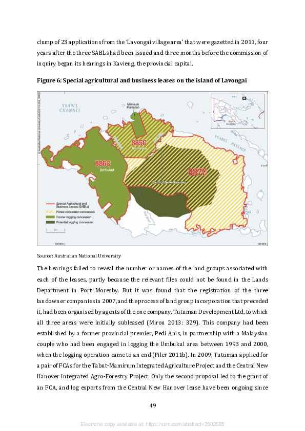
2011, while the other two leases have been subdivided into blocks that could be logged
under licences supposedly reserved for small-scale operations. Since 2012, logging
activities in all three areas have been undertaken by Joinland Ltd, whose two Malaysian
owners took control of the Tutuman company in 2014. The Central New Hanover lease,
like the West Aitape one, was somehow exempted from the National Executive Council’s
resolution to implement the recommendations of the commission of inquiry (Filer and
Numapo 2017: 267).

The 23 land groups incorporated in 2011 were most likely associated with the Central
New Hanover lease. Their incorporation might either be explained as a belated attempt
to engineer the appearance of landowner consent to the lease itself before it could be
investigated by the commission of inquiry, or else as a retrospective attempt to secure
the appearance of landowner participation in the agro-forestry project after the
developers had secured their FCA. However, when shares in the landowner company,
Central New Hanover Ltd, were redistributed between 27 land groups in 2011, only six
or seven of the new shareholders were among those listed in the application notice, which
suggests that the rest might not even have been registered as land groups.

Only one collection of land groups from Lavongai has been incorporated under the new
legal regime. There were 31 application and recognition notices gazetted in 2016, and
their clumping indicated the presence of a single organiser, but they only include four or
five of the 29 groups that were incorporated in 2006, and none of the groups that were
incorporated in 2011, nor any of those listed as shareholders of Central New Hanover Ltd.
The notices indicate that these 31 groups are scattered around 19 villages in the northern
part of the Lovongai (sic) LLG area, which suggests that their members claim portions of
land in areas that could be covered by the Mamirum or Central New Hanover leases. In
the year following their incorporation, the Central New Hanover agro-forestry project
was reportedly the subject of an agreement made between representatives of the
Department of Agriculture and Livestock, the New Ireland Provincial Government,
Joinland Ltd and a new ‘landowner company’ called New Hanover Industries Ltd (Gare
2017). But the 31 land groups were not shareholders in this new corporate entity. It had
instead been registered by Pedi Anis in 2015, the year after he sold his interest in
Tutuman to Joinland.


                                               50


                 Electronic copy available at: https://ssrn.com/abstract=3502585

The incorporation of these 31 land groups would remain something of a mystery if the
process had not been witnessed by an American anthropologist, Jason Roberts. He
reports that the process was initiated in 2014 by customary owners of the Mamirum lease
area who thought they would have to register their land rights to have any chance of
defeating attempts by Pedi Anis and his associates to revive or recycle their Tabut-
Mamirum agro-forestry project (Roberts 2019: 212–3). When provincial lands officers
told them that there was no government money available to pay for the cost of
registration, they registered a new landowner company, Atukulai Ltd, whose directors
entered into an agreement with a new development partner, Nagaplex (PNG) Ltd,
whereby the latter would organise and fund the process of incorporation and registration
on condition that the landowners would support their application for an FCA (ibid.: 226–
35).14 The Nagaplex project proposal proved to be remarkably similar to the one that
Joinland was already implementing in the neighbouring Central New Hanover area (ibid.:
262–66).

Nagaplex was not exactly a newcomer to Lavongai, but was incorporated at the same
time, and by the same people, as two other companies, Palma Hacienda Ltd and Growmax
(PNG) Ltd, that were contracted to implement Tutuman’s plans back in 2007. 15 Pedi Anis
subsequently claimed that the relationship broke down in 2010 because Growmax had
started illegally logging the Central New Hanover area before the FCA had been granted
at the end of that year, and its directors had then been ‘resourcing a minority group of ...
landowners to destabilise the majority’ by making public allegations that Tutuman had
sold their land from under their feet (Eroro 2011; Filer 2011b: 1). There followed a legal
dispute between the two companies about the ownership of some logging equipment that
dragged on until 2015, when Tutuman lost its case in the Supreme Court (PNGSC 2015).

The people engaged by Nagaplex to organise the incorporation of the 31 land groups and
the production of their survey plans in 2015 appear to have strayed into the Central New
Hanover area to recruit some of the dissident landowners who had opposed Tutuman in


14 Nagaplex personnel may even have organised the registration of the landowner company (Jason

Roberts, personal communication, August 2019).
15 It may be a coincidence that two of the directors of these companies, Huo Mee Hii and Kiong Mee Hii,

have the same surname as the Malaysian family whose members were involved in the establishment of
Tutuman.


                                                   51


                    Electronic copy available at: https://ssrn.com/abstract=3502585

2011 (Roberts 2019: 254–5). This provoked a reaction from the Tutuman camp, whose
members argued that the Mamirum SABL had not really been revoked, so the land still
belonged to Tabut and Tutuman. To reinforce their argument, they arranged for a
squadron of police to be conveyed to the Mamirum area in Joinland pickup trucks to make
a few arrests and threatened further legal action to block the Nagaplex agro-forestry
project (ibid.: 258–62). This did not prevent members of the Nagaplex camp from
organising the ‘public hearing’ that is required as a precondition for the grant of an FCA
(ibid.: 262–6), nor did it put a halt to the process of land group incorporation. However,
no survey notices have since been produced on behalf of the 31 land groups, and no new
application for an FCA had been made by the end of 2018, either by Nagaplex or Tutuman.
This is a stalemate that might or might not be broken in 2020, when the Central New
Hanover FCA is due to expire and some logging equipment may need a new home.

10.3 Lak Kandas Oil Palm Project

The Konoagil LLG area, at the bottom or southern end of New Ireland Province, was the
source of six application notices in 2015, seven in 2016 and four in 2017. Ten of the
application notices were followed by recognition notices, but none was followed by a
survey notice. All but one of the land groups that applied for recognition is clearly
associated with the development of the Lak Kandas Oil Palm Project. This project is being
implemented in two different parts of the LLG area. The Lak component, on the east coast,
covers an area of just over 15,000 hectares, while the Kandas component, on the west
coast, covers an area of just over 28,000 hectares. In 2015, the National Forest Board
issued an FCA covering a combined area of 43,520 hectares to Millionplus Corporation,
and log exports started in the following year.

The Konoagil LLG area accounted for 22 of the applications lodged under the old legal
regime, but none of them had anything to do with this agro-forestry project, which seems
to have been conceived in 2013 or 2014. There was a clump of 15 applications from the
Kandas area that were gazetted in 1995, and they were most likely associated with the
designation of this area as a potential logging concession in the National Forest Plan, but
no further steps were taken to negotiate an FMA with the local landowners. The Lak area
was subject to a logging operation in the 1990s, but like the Umbukul area on Lavongai,


                                               52


                 Electronic copy available at: https://ssrn.com/abstract=3502585

this was undertaken on the basis of a timber rights purchase agreement dating from
1989, so did not presuppose a process of land group incorporation.

The new oil palm scheme was the brainchild of Walter Schnaubelt, a local businessman
and martial artist, who made it part of his successful campaign to be elected as the new
MP for Namatanai District in 2017. He was described as the ‘spearhead’ in a public forum
held to discuss the scheme in the township of Namatanai in 2014 (Anon. 2014c). This
forum was understood to be a ‘public hearing’, but it was also stated that Konoagil
Landowners Association Ltd, representing 47 local land groups, would seek to obtain an
SABL, and would end up with a 30 per cent stake in the project. This assertion was at odds
with the moratorium already imposed on the lease-leaseback scheme, and the
Investment Promotion Authority has no record of a company by that name.

In April 2015, Mr Schnaubelt is reported to have taken 19 local land group chairmen to
meet with members of the New Ireland Provincial Forest Management Committee in
order to secure its support for the FCA (Kenneth 2015). The FCA was issued in October
that year, before any of the new land groups associated with the project had received a
recognition notice, and before most of them had even applied for incorporation. It would
therefore seem that the National Forest Board did not regard their existence as relevant
evidence of landowner consent or participation. Indeed, it is not clear why they have been
incorporated at all, since they are not listed as shareholders in either of the two
‘landowner companies’ associated with the project, one of which is owned by the other
one, nor do they seem to be represented in either of the two ‘landowner associations’ that
are among the three owners of the two companies (PNGexposed 2017).

In April 2016, when the project was officially launched by Treasury Minister Patrick
Pruaitch and Forests Minister Douglas Tomuriesa, Mr Schnaubelt announced that the
land groups had already been ‘processed’ but the process had not yet been completed
(Nalu 2016). Dissenting landowners, led by the LLG president, then complained to the
forests minister that the land group incorporation process had been ‘done in haste and
without the involvement of the landowners’ (Kenneth 2016). Some commentators have
argued that the whole project is ‘illegal’ because of the absence of genuine landowner
consent to what appears to be a partnership between corporate bodies controlled by Mr
Schnaubelt and his associates and the Malaysian company that is logging the area,


                                               53


                 Electronic copy available at: https://ssrn.com/abstract=3502585
Millionplus Corporation (PNGexposed 2016, 2017). 16 But Mr Schnaubelt argued that the
project was entirely consistent with the national government’s ‘public-private
partnership policy’, and it was up to the provincial government, not the private
developers, to secure local landowner support since the provincial government had
endorsed the FCA (Anon. 2016b).

10.4 Idam Siawi Agro-Forestry Project

A clump of 41 application notices gazetted on the same day in February 2017 might easily
have been confused with the clumps of application notices from adjacent areas of West
Sepik Province that were sponsored by Amanab Forest Products Ltd over the course of
the following year (see Section 5). That is because 33 of the 41 applications in this clump
came from the Green River LLG area, which was also the source of 56 of the 157
applications that had been organised by this logging company. However, in February
2018 it was reported that representatives of 45 land groups had signed a development
agreement for the Idam Siawi Agro-Forestry Project during a ceremony conducted at
Green River government station (Tarawa 2018). The other parties to this agreement were
said to be a local landowner company called Tangoy Holdings Ltd and their foreign
development partner, Vivafounder Investment Holdings Ltd. The relevant company
record reveals that the 45 land groups holding shares in Tangoy Holdings include the 35
groups from Green River LLG area that got their recognition notices on the same day in
April 2017 and the nine groups from the Namea and Yapsie LLG areas that got their
recognition notices on the same day in August that year. These 44 groups included the 41
that had their application notices gazetted in February.

Vivafounder Investment Holdings (PNG) Ltd was registered in 2015. It is a wholly owned
subsidiary of Shenzen Vivafounder Investment Holdings Ltd, which is based in
Shenzhen’s ‘Hongkong Cooperation Zone’ but not registered in PNG. In 2016, it entered
into a joint venture with Tangoy Holdings, and the new entity was registered as Tangoy
Vivafounder Holdings Ltd. This company has four directors from mainland China and
three directors representing the landowner company. It seems that the joint venture
produced an agricultural development plan and an environmental impact statement for


16 Millionplus Corporation is owned and controlled by the same two Malaysians who own and control

Joinland, the developer of the Central New Hanover rubber project.


                                                  54


                   Electronic copy available at: https://ssrn.com/abstract=3502585
the agro-forestry project in 2017 and that the National Forest Board consequently
granted an FCA at some point in 2019.

More recent newspaper articles have raised a number of questions about the authenticity,
scale and substance of this project. The first one declared that the FCA covered an area of
‘at least 789,000 hectares’, but also reported that five MPs from East and West Sepik
provinces, including the two provincial governors, had agreed to put a stop to it ‘because
landowners were not consulted and never gave consent’ (Nanau 2019a). The second one
was based on a press release from one of the directors of Tangoy Holdings, declaring that
the project had the full support of the Sandaun (West Sepik) Provincial Government and
that Vanimo-Green MP Belden Namah had spent K500,000 out of his district slush fund
to pay for the process of land group incorporation (Nanau 2019b). The third one was
based on a press release from the governor of West Sepik Province, Tony Wouwou, who
said that the ‘first phase’ of the project covered an area of 188,000 hectares, and that
Vivafounder Investment Holdings had done a much better job of securing landowner
consent than other companies operating in his province, noting that the deal had been
‘unanimously endorsed’ by local landowners at a public hearing conducted in one of the
Green River villages in October 2016. He went on to deny that he or the other MPs
mentioned in the first article, including Mr Namah, had resolved to put a stop to what he
called ‘a potential billion kina investment project’ (Anon. 2019).

The most obvious puzzle concerns the size of the area covered by the FCA. If it is indeed
789,000 hectares, as reported in two of the latest newspaper articles (Nanau 2019a,
2019b), this would make it more than three times the size of any other FCA so far granted
by the National Forest Board. However, Mr Wouwou’s press release, most likely based on
documents presented to his provincial forest management committee, suggests that
someone might have mistaken a ‘1’ for a ‘7’, thus making the area four times bigger than
it really is. The Idam Siawi forest area looked as if it covered an area of less than 200,000
hectares when it made its first appearance as a ‘potential area for future development’ in
the 1996 National Forest Plan (GPNG 1996), although its size was not specified in that
document. There it was shown as an area covering most of the southern part of the Green
River LLG area at the southern end of Vanimo-Green District and some adjacent parts of
the Yapsie LLG area in Telefomin District.


                                               55


                 Electronic copy available at: https://ssrn.com/abstract=3502585

By 2009, this forest area had disappeared from the Forest Authority’s list of potential
logging concessions, but then it reappeared in a new (draft) version of the National Forest
Plan, this time with a gross area of 781,501 hectares but without a map to show how its
boundaries had been enlarged (GPNG 2012: 43). The reason for this enlargement would
have been that the area designated in 1996 would not have contained enough
‘merchantable timber’ to qualify for an FMA under the terms of the National Forestry
Development Guidelines (GPNG 1993). In the new scheme of things, a budget of K240,000
was allocated to the process of resource acquisition — in other words, to the production
of an FMA — and this included K50,000 for the process of land group incorporation. But
it is hard to regard this undertaking as anything more than a fantasy. Officers of the
National Forest Service have not been able to come up with a new FMA since 2010, when
they negotiated the agreement that enabled the Imonda forest area to be added to the
concession now held by Amanab Forest Products.

The question of scale might be resolved if the Conservation and Environment Protection
Authority would allow public access to the environmental impact statement that was
apparently produced in 2017 (TVH 2017). Unfortunately, the relevant officials have been
reluctant to do so, even though Section 55 of the Environment Act of 2000 says that they
should ‘be made available for public review’. The few people who have gained access to
this document include the consultants who produced another environmental impact
statement for a large-scale mining project that may yet be developed in a location close
to the border between the two Sepik provinces. Furthermore, the proponents of this
mining project have followed what is now standard practice in PNG’s extractive industry
sector by uploading the latest version of their own environmental impact assessment to
their own corporate website (CSA 2018), thereby undermining the regulator’s efforts to
avoid the transparency required by its own legislation.

The mining company’s environmental impact statement says that ‘phase one of block one’
of the Idam Siawi project will clear an area of forest similar to that shown in the 1996
National Forest Plan and replace it with ‘oil palm, paddy rice, sago, cassava, spices and
vegetables, and stock including cattle, poultry and pigs’ (CSA 2018: 10.7). Although this
forest area straddles the northern section of the new road that the mining company is
proposing to build from Hotmin village to Green River government station, which
includes a very expensive bridge across the Sepik River, the agro-foresters are not

                                               56


                 Electronic copy available at: https://ssrn.com/abstract=3502585
expected to make use of this new economic infrastructure. Instead, they are reportedly
planning to build ‘430 km of new roads and tracks’ on their own account (ibid.: 10.10)
and then presumably find another way to move their logs across the Sepik before trucking
them along the road already built by Amanab Forest Products in order to reach the port
of Vanimo (see Figure 7). Since the mining company, Frieda River Ltd, is a wholly owned
subsidiary of a Chinese state-owned enterprise, Guandong Rising Assets Management,
and has been so since 2015, one might anticipate some form of collaboration with the
Chinese companies investing in the agro-forestry project, but there is as yet no evidence
of this.

While the mining company’s environmental consultants say that the agro-foresters have
not been looking to clear much more than 141,000 hectares in the first phase of their
project, they also say that the long-term plan extends to 780,000 hectares (CSA 2018:
10.7). If that is the case, then the ultimate target would seem to be aligned with the
boundaries of the FMA that will never be signed. These boundaries are shown in
Appendix 9 of the mining company’s environmental impact statement (Lechner et al.
2018: 15), and seem to have been derived from a 2016 version of the West Sepik (or
Sandaun) provincial forest plan. The further expansion of the agro-forestry project would
therefore have to be based on a number of new FCAs covering substantial areas of forest
in Yapsie, Telefomin and Oksapmin LLG areas.

The spokesman for Tangoy Holdings claims that his company has been designed to
represent all the customary owners of these additional forest areas because the name
‘Tangoy’ is an acronym derived from the initial letters in the names of five LLG areas,
including Telefomin and Oksapmin, as well as Green River, Namea and Yapsie (Nanau
2019b). However, there is not one single land group from either the Telefomin or
Oksapmin LLG areas that currently holds shares in this company, and there are only two
from the Yapsie LLG area.17


17 It is not even clear why seven groups from a single village in the Namea LLG area hold shares in this

company, since the whole of that LLG area is located to the north of the Sepik River, and the western half
of it is already covered by another FCA.


                                                    57


                    Electronic copy available at: https://ssrn.com/abstract=3502585
Figure 7: Proposed road link between Frieda River mine and Vanimo


Source: CSA 2018, Figure 1.5


                                                 58


                   Electronic copy available at: https://ssrn.com/abstract=3502585
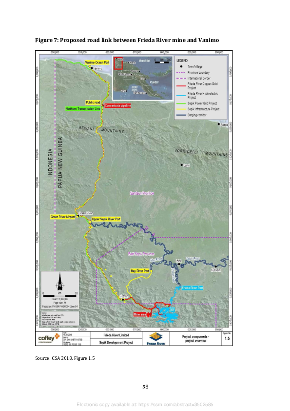
From existing reports, it seems quite clear that the main source of political support for
the first phase of the Idam Siawi project has come from Belden Namah. Mr Namah has
been the MP for Vanimo-Green District since 2007. was the forests minister during his
first three years in the national parliament, ushered in the changes to the Forestry Act that
made it much easier for the National Forest Board to grant forest conversion concessions,
and then took advantage of these changes to sponsor several agro-forestry projects in his
own electorate. But if there is to be any southward expansion of the Idam Siawi project,
it can only take place in the Telefomin electorate whose current MP, Solan Mirisim,
happens to be the current forests minister. Mr Mirisim is not known have made any public
statement about the way that this expansion might be organised, or even if he thinks it is
a good idea. However, Tangoy Holdings, as currently constituted, could not possibly be a
legitimate vehicle for the organisation of landowner consent to such an expansion. If it is
going to take place at all, then we would have to anticipate a further process of land group
incorporation, either followed by the addition of new shareholders to the landowner
company that already exists or else by the formation of new landowner companies to
represent Mr Mirisim’s constituents.

11.    The growth of urban bias

If it were not for the very large number of applications from West Sepik Province, the new
legal regime would appear to be one in which land groups based in urban and peri-urban
areas have a greater incentive or opportunity to register their existence, and even more
of an incentive to register their land titles. The proportion of applications from urban and
peri-urban areas has risen from less than 5 per cent under the old regime to more than
10 per cent under the new one. The national capital alone has accounted for more than
5 per cent of the applications lodged under the new regime (see Table 4). About one third
of the 157 survey notices gazetted since 2013 have clearly come from urban and peri-
urban areas, and if we discount the 28 notices from the West Aitape LLG area that were
gazetted in 2018, the proportion rises to 40 per cent. Groups based in such areas also
account for 40 per cent of the 75 land title notices gazetted since 2013.

Applications from groups based in urban and peri-urban areas have rarely been clumped
together in ways that point to the presence of an organiser who is not a member — or at
least pretending to be a member — of one of the groups that are being incorporated. If


                                               59


                 Electronic copy available at: https://ssrn.com/abstract=3502585
there is now more of an incentive or opportunity for the customary owners of land in
urban or peri-urban areas to get their own groups organised, then one might suppose
that their leaders would by now have organised the reincorporation of all the groups that
were first incorporated under the old regime. However, as previously noted in the case
of groups holding SABLs in their own right, this kind of replication appears to be quite
limited. In the national capital alone, only 23 of the 110 land groups that applied for
incorporation under the old regime have since attempted to reincorporate themselves
with the same name, so they account for less than 40 per cent of the 63 groups that have
been subject to application and/or recognition notices since 2013. In the absence of any
additional information, it is hard to tell whether this is due to the fact that people have
decided to change the names of their groups, or whether new groups have been created
from different sections or fractions of older groups, or whether there has been some
change in the reasons why the indigenous Motu-Koitabu people of Port Moresby would
want to get themselves organised in this way.

As we have seen, there are only three cases in which the Commission of Inquiry into
SABLs cast new light on the question of motivation in urban and peri-urban areas. More
light has been cast by the content of articles, letters and advertorials published in the
national newspapers, because residents of these areas have better access to journalists
than those living in rural villages. This is especially the case when the same newspapers
publish survey notices that invite their readers to object to a group’s land claims and
when those claims are quite substantial. The question is whether the motivations of
groups that participated in the lease-leaseback scheme before the new legislation came
into effect in 2012, like the Vaga and Tubumaga groups in the national capital, are typical
of all the groups in urban and peri-urban areas whose leaders have decided to engage
with the new legal regime.

11.1 Land groups under a peri-urban local-level government

The Ahi LLG area in Morobe Province is officially ‘rural’, but actually surrounds the Lae
urban LLG area. The two areas are described in the 2000 national census as two different
parts of the city of Lae, and are together represented by a single MP in the National
Parliament. The whole of the urban LLG area, but only part of the Ahi area, consists of
land that was alienated during the colonial period. The Ahi people who claim descent


                                               60


                 Electronic copy available at: https://ssrn.com/abstract=3502585
from the customary owners of the land that was alienated are mostly affiliated with one
or other of the four ‘villages’ in the Ahi LLG area. These villages accounted for
approximately 5 per cent of a resident population of more than 50,000 in 2011, and just
over 2 per cent of the population of Lae District as a whole. Nevertheless, most of the MPs
who have been elected to represent that district have been Ahi community leaders, even
if they have not been resident in one of the four Ahi villages.

Twelve land groups from the Ahi LLG area were incorporated under the old legal regime.
Four of them had their application notices gazetted on the same day in 2007. Seven
groups have been incorporated under the new regime, of which five appear to have been
incorporated under the old one, although two of them were formerly incorporated as a
single group and two of them have changed the spelling of their names. 18 Most of the
groups incorporated under the old regime, and all of those incorporated under the new
one, have been associated with one of three locations — Butibam, Kamkumung or Yanga.
Butibam and Yanga are two of the four Ahi ‘villages’, while Kamkumung is counted in the
2000 census as one of many ‘settlements’ in the area, albeit one that seems to contain a
significant number of customary landowners who prefer to call it a village. 19

Only three of the newly incorporated groups have managed to produce a survey notice.
The Busulum group from Butibam had already been responsible for a survey notice
covering seven different land portions, with a combined area of just over 28 hectares, that
was gazetted in 2012, before the new legal regime came into effect and before the group
was reincorporated in 2016. The same group then produced another survey notice
covering two land portions, distinct from the portions named in the previous notice, with
a combined area of less than 1 hectare, but this did not lead to an acceptance or land title
notice. The Uapu group from Kamkumung was more successful. This group was also
reincorporated in 2016, produced a survey notice in 2017, and got its acceptance and
land title notices for an area of more than 100 hectares on the same day in 2018. This
appears to be a block of land dedicated to the construction of a new residential and
commercial suburb, rather like the blocks belonging to some of the leaseholding land


18 The names of clans or land groups are often spelt differently in different documents, including

newspaper articles. To avoid confusion, I have adopted the spelling contained in the most recent gazettal
notice.
19 A sixth Ahi village, Yalu, is located in the Wampar LLG area, to the west of the city.


                                                    61


                    Electronic copy available at: https://ssrn.com/abstract=3502585
groups discussed in Section 7 (Bailey 2016). The Apo Malac Wampom group from
Butibam produced a survey notice covering a single land parcel of less than 2 hectares in
2017 but, like the Busulum claim, this has not led to an acceptance or land title notice.

As early as 2005, it was noted that the Ahi villagers had adopted their own ‘land
mobilisation policy’ in response to the ‘uncontrolled occupation of their customary lands
by people migrating to Lae from other areas’, and were already planning to register land
group titles so that they could reassert some level of control (Fingleton 2005). By 2008,
some of them had established a body called the Ahi Land Mobilisation Committee (Korugl
2009), and the Ahiwapac land group from Kamkumung, which is one of the seven now
incorporated under the new legal regime, had apparently leased some of its land to the
Lae Waterboard for the construction of staff housing (Rai 2007).

However, the process of mobilisation was disrupted by a sequence of legal disputes that
were not simply concerned with the question of who had the right to engage in such
transactions, but also with the exercise of customary rights over land that may or may
not have been alienated during the colonial period. The National Court referred this
second matter to the Land Titles Commission in 2006 (Korugl 2009), which amounted to
a guarantee that it would not be settled any time soon. In the meantime, there was an
increase in the number of groups claiming to be customary owners of alienated land in
different parts of the city, and hence demanding a right to benefit from its redevelopment
(Korugl 2008). Some of the people making these claims and demands were not
recognised as members of the Ahi ethnic group, and that in turn seems to have provoked
a dispute among the 14 ‘major clans’ supposedly represented by the Ahi Association. One
faction, which included leaders of the Busulum group from Butibam, demanded an end to
further dealings between the other faction and a number of different companies and
government agencies while the Land Titles Commission had yet to make a ruling (Banige
2009; Korugl 2009). The trouble with this approach was that some of the development
projects subject to such negotiations were already well advanced in their preparation or
implementation, and the developers did not have time to wait for a ruling that might not
be made for months or years to come.

The biggest of these was the Lae Port Tidal Basin Project, initially funded by a loan from
the Asian Development Bank. This involved a substantial upgrade of the port facilities


                                               62


                 Electronic copy available at: https://ssrn.com/abstract=3502585

located between the city boundary and the mouth of the Markham River. In 2008, the
implementation of this project was threatened by leaders of the Busulum group and those
of another Butibam group, called Wapic Guhu, which was the first Ahi land group to be
subsequently reincorporated under the new regime. Their complaint was that the
national government had not shown the ‘respect’ that was due to them as the result of a
Supreme Court decision to recognise their groups as the customary owners of the port
site back in 1971 (Anon. 2008a). But a representative of the people then living on the land
that would be required for the port’s expansion, who seem to have originated from
villages belonging to the Labu ethnic group in the Wampar LLG area, promptly denied
that the Ahi people had any right to be consulted about the project’s resettlement
program since they would not be affected by it (Anon. 2008b). Some years later, this
particular dispute was said to have been resolved by means of a benefit-sharing
agreement between representatives of the three Labu villages and all six Butibam clans,
whereby the Busulum clan was recognised as the original owner of the land in question
(Anon. 2018d). This followed a previous agreement between representatives of the
Busulum and Wapic Guhu groups and relevant national government agencies that
acknowledged the secondary interests of the other four Butibam clans (Nebas 2011).

Newspaper articles have consistently recorded the existence of the same six clans in
Butibam Village (Korugl 2009; Anon. 2018d, 2018e), and the village is now said to have
its own ‘council of chiefs’ containing the six clan leaders (Anon. 2018e). 20 The identities
and provenance of the other ‘major clans’ represented by the Ahi Association or the Land
Mobilisation Committee have not been so clearly specified, but the recognition of 14 clans
as the customary owners of 11,933 acres (or 4,829 hectares) of alienated land in what is
now Lae District is said to date back to a colonial Supreme Court ruling made in 1966
(Kapin 2016). Yet some of these 14 clans do not seem to have applied for incorporation
as land groups either under the old legal regime or the new one, and only five of the
groups that have been reincorporated since 2013, including three of the six Butibam
clans, can be identified as part of the larger collection covered by the Supreme Court
ruling.


20 These may be the six groups that are said to have been incorporated by 1990 with support from the

UNDP-funded Urban Settlement Planning Project (Fingleton 2007: 29). However, their names are not on
the list of previously recognised land groups that was gazetted in November 1993.


                                                  63


                   Electronic copy available at: https://ssrn.com/abstract=3502585

The reincorporation of the Busulum and Wapic Guhu groups might be explained by their
prominence in negotiations over the redevelopment of the port. But if the leaders of other
groups have been reluctant to pursue the process of incorporation, even under the old
legal regime, that might be explained by the risk of internal disputes about who should
occupy which roles in the management committees that have to be established as part of
the process. When the Wapic Guhu group received its recognition notice in 2014, a local
councillor claimed that this was a ‘bogus’ group established by local ‘fraudsters’, in league
with corrupt lands officers, who were making claims on land that belonged to some of the
other Ahi clans, and that their actions had led to disputes between families within their
own group (Nebas 2014). This claim echoed previous arguments about who had the right
to represent this group in negotiations over the redevelopment of the port (Rai 2009,
2011; Anon. 2011).

It is not even clear why land groups would bother to get themselves incorporated or
reincorporated under the new legal regime if the main concern of their members was
with the distribution of benefits from the redevelopment of land that had already been
alienated, especially if they had already agreed to recognise one person as their ‘chief’ for
the purpose of negotiating a benefit-sharing agreement. In any case, local clan leaders
have not been the only — or even the principal — actors in such negotiations. Ahi
community leaders established a network of landowner companies for this purpose, and
have preferred to nominate themselves as shareholders and directors of these companies
on the understanding that they function as trustees for the rest of the community. In
2015, it was reported that one of the Ahi companies, Ahi Holdings Ltd, had formed a joint
venture with its Labu community counterpart, Labu Holdings Ltd, to secure what was
described as a ‘stranglehold’ on stevedoring operations at the new port (Anon. 2015b).
The joint venture has not been registered as a separate company, so it may have fallen
victim to the ongoing dispute about which ethnic group contains the customary
landowners (Kivia 2014; Avediba 2015). Nevertheless, profits from the stevedoring
business enabled another Ahi company, Ahi Investment Ltd, to distribute a dividend of
K1.7 million to members of the Ahi community in 2018 (Kapin 2018).

These Ahi companies are located at the peak of a nested hierarchy of landowner
companies. Butibam Village has its own company, Butibam Progress Ltd, whose sole
shareholder is the Butibum Progress Association, and whose six directors represent the

                                               64


                 Electronic copy available at: https://ssrn.com/abstract=3502585

six village clans or their chiefs. This company has a contract with the Lae urban council
to manage the city’s recreational spaces (Baunke 2017). The Busulum clan also has its
own company, Busulum Holdings Ltd, whose managing director argued that it should get
special privileges in the stevedoring contract because of the clan’s status as the customary
owner of the port site (Kivia 2015). Yet that does not seem to be the reason why the
Busulum land group was reincorporated in 2016, since the land group is not the owner
of the company. Like the Ahi group of companies, its shareholders and directors are
individual community leaders.21

If the new cluster of Ahi land groups has not been motivated by people’s desire to
participate in this network of landowner companies, can it be explained by their desire
to register new titles over customary land? As we have seen, there is only one group that
has actually secured a registered title, and it is not clear what sort of development has
taken place on the land covered by it. What is noticeably lacking is a process comparable
to the one already documented in Port Moresby’s Taurama Valley, where the primary aim
was to stop informal sales of customary land to migrants or foreigners. But if the
registration of group titles is not seen as a solution to this problem in the Ahi LLG area,
this does not mean that there is no problem to be solved.

In 2012, two ladies from Butibam Village complained to police that one of their relatives
had fraudulently sold two blocks of their customary land to a Malaysian businessman,
and even got the six clan chiefs to endorse their complaint (Kivia 2012). In 2013, the
provincial governor, the sitting MP and a former MP told fellow leaders of the Ahi
community that it was ‘time to control the uncontrolled sale of Ahi land and turning their
land into squatter settlements’ (Philemon 2013). Later that year, the chair of the Land
Mobilisation Committee, from Kamkumung Village, was threatening to evict the 2,000
residents of a settlement on his own clan’s customary land after a fight between two
groups of highlanders (Anon. 2013). More recently, when a Butibam villager was
allegedly killed by a group of squatters, it was a senior police commander who called on
the Ahi people to stop selling their land to outsiders (Anon. 2018f). In these


21 One of its directors, Sir Nagora Bogan, former head of PNG’s Internal Revenue Commission, is also a

director of Ahi Holdings Ltd.


                                                   65


                    Electronic copy available at: https://ssrn.com/abstract=3502585
circumstances, it seems rather odd that only one of the 14 Ahi clans has managed to
secure a single land title since the new legal regime came into effect.

11.2 Land groups under the Poreporena–Napa Napa Development Plan

The Poreporena–Napa Napa Local Development Plan (PNLDP) was initially drafted in
2012 and finally approved by the National Capital District’s Physical Planning Board in
2014. Its main focus is the construction of new buildings and facilities along the route of
the road that encircles Fairfax Harbour, connecting Hanuabada Village, which lies to the
north of Port Moresby’s central business district, to the Napa Napa oil refinery, on the
opposite side of the entrance to the harbour (see Figure 5). Among other things, it
proposes the development of two new suburbs — Konebada Junction, at the
northwestern corner of the harbour, and Napa Napa, between Roku Village and the
southern reaches of the harbour.

Once it has passed Motukea Island, the road corridor becomes the boundary between
National Capital District and Central Province, so most (though not all) of the
development is meant to take place on the coastal side of the road. There are substantial
areas of customary land on both sides of the road, especially after it turns south at the
western end of Fairfax Harbour. We should therefore expect that implementation of the
PNLDP would be accompanied by concerted attempts to ‘mobilise’ this land under the
new legal regime that came into effect when the plan was being drafted.

The customary landowners of National Capital District assign themselves to one or other
of a dozen Motu-Koitabu ‘villages’ that jointly account for 6 or 7 per cent of the resident
population. Hanuabada (meaning ‘Great Village’ in the Motu language) is actually a cluster
of settlements with their own distinctive names, 22 with a combined population of more
than 7,000 in 2011. However, most of the customary land required for implementation of
the PNLDP belongs to the residents of three smaller villages — Tatana, Baruni and Roku
— that had a combined population of less than 7,000 in 2011.

It is not possible to calculate the precise number of land groups from these three villages
that were incorporated under the old legal regime since groups with the same name, or

22 They are sometimes known collectively as the ‘Poreporena villages’, but most city residents apply the

name Hanuabada to the whole lot.


                                                   66


                    Electronic copy available at: https://ssrn.com/abstract=3502585
very similar names, have been incorporated at different times. 23 There were certainly no
more than 30 of them. There are 26 or 27 groups that have been the subject of application
or recognition notices under the new regime. About half of these appear to be old groups
that were reincorporating themselves, while the other half appear to be new groups, or
possibly old groups with new names. Only seven groups have produced survey notices
since 2013, but four of them had not received an acceptance or land title notice by the
end of 2018, and one of them had not even been the subject of an application notice under
the new regime. From a reading of the National Gazette, it would appear that three groups
from Baruni Village had managed to secure titles over a combined area of more than
100 hectares by that time, but no titles had been officially awarded to groups from the
other two villages.

As previously noted, the Tubumaga group from Tatana Village secured an acceptance
notice for its claim to ownership of Idumava Point without a prior survey notice or a
subsequent title notice. This group was originally incorporated in 2003 and then
reincorporated in 2014, when its recognition notice was gazetted less than ten days after
its application notice. The speed of this transaction prompted leaders of the Tanomotu
clan from Roku Village to complain that it had denied them the opportunity to object to
the application on the basis of their own claims to be the customary owners of the LNG
plant site and part of Motukea Island (Anon. 2014d). The first of these claims was
somewhat misleading, because the branch of the Tanomotu clan whose members were
recognised as customary owners of the plant site buffer zone was the one based in
Kouderika Village, on the other side of the plant site itself. Neither claim had any obvious
connection to disputes about the ownership of Idumava Point; the Roku branch of the
Tanomotu clan has not been reincorporated under the new legal regime; and its leaders
have otherwise taken no part in a separate argument about which groups have customary
rights to Motukea Island. The Tubumaga group, despite the speed of its own
reincorporation, has not been party to that argument either.


23 I do not know whether the Laurina group from Tatana, which was incorporated in 1996, is the same as

the Laurina Iduhu group from the same village, which was incorporated in 2001, given that the Motu
word iduhu is commonly translated as ‘clan’.


                                                  67


                   Electronic copy available at: https://ssrn.com/abstract=3502585
Unlike the scheme hatched by Rose Haraka and her associates, the new international
shipping terminal on Motukea Island is an integral component of the PNLDP.24 By the
time that this facility was opened in 2018, its operator, International Container Terminal
Services Ltd, had signed a benefit-sharing agreement with representatives of another set
of land groups from Tatana and Baruni villages whose ancestors were deemed to have
sold the island to the colonial administration in 1899.25 This was the result of a sequence
of negotiations and disputes that began when Curtain Brothers sold its lease over a
portion of the island to the Independent Public Business Corporation (now Kumul
Consolidated Holdings) and PNG Ports Corporation in 2015. It therefore resembles the
settlement of customary group claims to benefit from implementation of the Lae Port
Tidal Basin Project, which also took place on land alienated during the colonial period.
Indeed, the chairman of the Kaevaga land group from Baruni Village made explicit
reference to the similarity when he staked a claim to ownership of all the adjacent
customary land (Anon. 2015c).

As if to reinforce the comparison, the representatives of three groups from Tatana Village
then said they were descended from the customary owners of the island itself, as
demonstrated in the original purchase documents, so the Kaevaga chairman was
speaking out of turn (Anon. 2015d, 2015e; Wille 2015). Such questions of ancient history
were displaced by the formation of a new company called Motukea United Ltd, which was
registered in 2016 as a joint venture between the new port’s operators and two
landowner associations representing all the residents of Tatana and Baruni villages. It is
not clear whether this initiative created new business opportunities for local landowner
companies,26 but it does not seem to have removed the incentive for local land groups to
register titles to customary land beyond the boundaries of the new port facility.

In 2018, the ‘chairman’ of the Kaevaga group’s dispute settlement authority, Nou Nou,
complained that the port’s operators were making use of the group’s customary land


24 The PNLDP envisages the construction of a new housing estate on Idumava Point, but there is as yet no

sign of this plan being implemented (see Figure 5).
25 At that time the island was barely 7 hectares in size. Most of the current island, which covers more than

100 hectares, has been created by a process of land reclamation over the past four decades.
26 Three Tatana clans were reported to have established a separate landowner company called Motukea

Landowner Holdings Ltd to negotiate the distribution of spin-off benefits from development of the port
(Anon. 2016c), but no such entity has been registered with the Investment Promotion Authority.


                                                    68


                    Electronic copy available at: https://ssrn.com/abstract=3502585
without providing the business and employment opportunities that had been promised
in return (Anon. 2018g). The land portion number mentioned in his complaint — 3646
— does not correspond to either of the numbers attached to the two small portions of
customary land, both called Sasiva, that were the subject of survey notices gazetted in
2015 and 2017. However, documents obtained from the Lands Department show that the
group had indeed managed to secure a title to Portion 3646C, which is also called Sasiva,
back in 2016. This is an area of 171 hectares immediately to the north of Motukea Island.
It is not clear whether the port’s operators have so far made any use of this land, although
the part to the north of the main road is earmarked for ‘general industrial use’ in the
PNLDP, while the part between the main road and Motukea Island is bisected by a new
causeway connecting the island to the mainland.

In October 2016, the chairman of the Kaevaga group itself, Haraka Borema, signed an
affidavit stating that his group had agreed to sell part of this ‘Sasiva land’ to Simbu
businessman Jacob Kaupa and his company, Pacific Corporate Security Ltd. This
document was submitted to the Land Titles Commission as evidence that the land in
question, now designated as Portion 3647, was no longer customary land. This is an area
of some 44 hectares, located to the south of the main road and east of the new causeway.
Once established as its new owner, Mr Kaupa would be able to sell the land to the state in
exchange for a 99-year lease, which would make sense because state leases are now
widely regarded as the only ‘bankable’ form of land title (Brian Aldrich, personal
communication, October 2019). However, leaders of the Kaevaga group were able to
thwart Mr Kaupa’s plans by securing their collective title to Portion 3646C, which
includes Portion 3647, two months after the latter had supposedly been sold. In any case,
most of the ‘Sasiva land’ to the south of the main road consists of mangroves, and the
whole of it is earmarked for ‘environmental protection’ in the PNLDP, so it is not clear
whether any of its putative owners are in a position to make much of a profit out of its
development.

Meanwhile, another piece of ‘Sasiva land’, immediately to the west of Portion 3646C, was
somehow acquired by Larry Andagali, the managing director of Trans Wonderland Ltd,
one of the major subcontractors engaged in development of the PNG LNG Project. It is not
clear who might have sold this land to Mr Andagali, nor is it clear who had any right to do
so, since two or three of the clans based in Baruni Village have been disputing its

                                               69


                 Electronic copy available at: https://ssrn.com/abstract=3502585
ownership for many years, and that is why no one group has tried to register a title over
it.27 Mr Andagali appears to have followed the same legal path as Kaupa in his efforts to
secure a legal title for himself or his company, and has apparently been more successful.
Nevertheless, his deployment of earthmoving equipment to the area has since resulted in
the issue of a stop-work notice by Motu Koita Assembly chairman Dadi Toka Jr, who
claims that Mr Andagali has failed to secure the necessary approvals. This action has been
applauded by Mr Nou, now described as a ‘Sasiva landowner’, on the grounds that people
like himself should have a ‘fair share’ of the equity in such developments (Nao 2019).

The redevelopment of Motukea Island itself included plans to relocate the Defence
Department’s naval wharf and base to an adjacent area of customary land known as
Arutu. This move was welcomed by the chairman of the ‘Arutu ILG’ at what was described
as a ‘ground breaking ceremony’ in 2015 (Anon. 2015f). There were in fact two land
groups that received their certificates of recognition on that occasion. One was based in
Tatana and had already been incorporated under the old legal regime, while the other
was based in Baruni and was now being recognised for the first time. However, these two
local branches of the Arutu clan were clearly acting in concert, since both had their
application notices gazetted on the same day in 2014, their recognition and survey
notices on the same two days in 2015, and their acceptance and land title notices on the
same day in 2016. Furthermore, each group ended up with a title over just under
79 hectares of land.28 The combined area of 158 hectares is located to the north of the
main road and northwest of Motukea Island, and it contains a gravel pit from which
Curtain Brothers extracted some of the material used to enlarge the island itself (see
Figure 5).29 Indeed, it was staff of Curtain Brothers who conducted the surveys that led
to the grant of the two land titles (Justin McGann, personal communication, October
2019). However, once the titles had been granted, a dispute took place between the


27 Curtain Brothers had plans to make use of this land more than ten years ago, and initially made an

agreement with leaders of the Tanomotu clan who claimed to be the customary owners. However, these
plans were aborted when members of other groups pursued their own claims through the local land court
(Justin McGann, personal communication, October 2019).
28 The Defence Department thought that it was going to acquire three portions rather than two, covering a

total of 226 hectares (Griffin 2017: 33–4). The third portion would have consisted of land below the high
water mark on which the wharf would have been constructed.
29 The extraction of gravel from customary land requires an agreement to pay royalties to the customary

owners. Arutu clan members are said to have received royalties worth about K10 million since extraction
started (Justin McGann, personal communication, October 2019).


                                                    70


                    Electronic copy available at: https://ssrn.com/abstract=3502585
leaders of the two title-holding groups, which effectively put an end to their negotiations
with the Defence Department.

The three Tatana groups whose leaders made historical claims to ownership of the new
Motukea port site also tried to register titles to areas of customary land beyond its
boundaries, although none had got further than the production of a survey notice by the
end of 2018. The Nenehi Dubu group produced notices covering three separate portions,
with a combined area of almost 25 hectares, between 2013 and 2015; the Idibana Tatana
group produced one notice covering just over 60 hectares in 2016; and the Nenehi
Laurina group produced one notice covering 9 hectares in 2018. At least one of these
claims was related to a new proposal to move the naval wharf and base to the southern
side of Fairfax Harbour.

In 2018, representatives of several land groups from Tatana Village, this time including
the Tubumaga group, but not the Arutu group, were disputing the question of who owned
how much of the 240 hectares of customary land that would be required for this purpose
(Kenneth 2018; Nao 2018a). One of the matters raised in this dispute was the ‘Iduvaivai
decision’ supposedly made by a local land court in 1993, and then supposedly confirmed
by the National Court in 2008 and the Supreme Court in 2011, so the land in question
seems to be located to the west and south of Idumava Point. The chairman of the Nenehi
Laurina group said that this land was divided into four parts, one of which was called
Geugeu, but none of which was called Iduvaivai, and the ownership of each part was still
being debated in yet another local land court hearing (Nao 2018b). Geugeu is the name
of the 60-hectare portion subject to the survey notice produced by the Idibana Tatana
group in 2016, and since the survey itself was also undertaken by staff of Curtain
Brothers, it has been possible to establish that the name refers to the peninsula
immediately to the west of Idumava Point and north of the road to the refinery (Justin
McGann, personal communication, October 2019). However, none of the other three land
names invoked by the Nenehi Laurina chairman corresponds to the name of a land
portion nominated in a local land group’s survey notice, and there is no evidence to
suggest that negotiations with the Defence Department have made any further progress
on this front.


                                               71


                 Electronic copy available at: https://ssrn.com/abstract=3502585
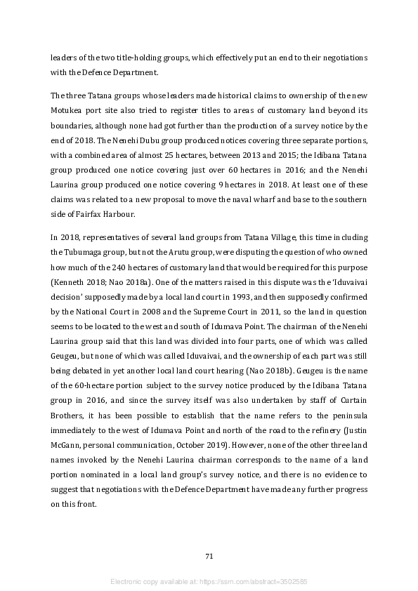
11.3 Ohobidudare transformations

By far the largest block of customary land to have been ‘mobilised’ in accordance with the
PNLDP is an area of 585 hectares that goes by the name of Ohobidudare. This was the
subject of an SABL issued to a land group of the same name in 2010. The associated survey
plan shows that the land area covered by this lease stretches west and north from Roku
Village, where the land group is based, between the south coast of the mainland and the
southwestern shores of Fairfax Harbour. It therefore traverses the road that constitutes
the boundary between Central Province and National Capital District (see Figure 5). The
complexity of the transactions to which this land has been subject since 2010 exemplifies
the failure of the new legal and institutional regime to fill the legal holes created by
suspension of the lease-leaseback scheme. The history of these transactions also
illustrates the level of confusion that now surrounds the legal relationship between
customary landowners, urban property developers and state regulators.

In June 2018, the chairman of the Kuriu land group, Inogo Gabe, who was also described
as the ‘principal landowner’ of Ohobidudare, featured in a ceremony conducted by Lands
Minister Justin Tkatchenko to commemorate the grant of leases over several different
portions of the land formerly covered by the SABL (Anon. 2018h; Poriambep 2018).
According to one report, the landowners had agreed to lease their land to the state for a
period of 99 years and would somehow receive land titles and rental payments in return
(Poriambep 2018), but according to a second report, they had signed a lease agreement
with Avenell Engineering Systems Ltd while having their land ‘converted to state lease
for private development purpose’ (Anon. 2018h). From these stories alone it was hard to
tell whether the land group had secured titles to different land portions and then leased
them to the developers, had sold their land to the state so that the state could issue its
own leases to the developers, or else leased their land to the state so that the state could
issue subleases to the developers.30 In any case, Mr Gabe’s own right to engage in any of
these transactions was promptly challenged by other claimants to membership of the
Kuriu clan who published an advertorial declaring that he was not the ‘principal
landowner’, was not even a ‘legitimate owner of the land’, so they would refer the whole


30 The second and third of these options are available under Sections 10(2) and 10(4) of the Land Act

1996, but customary landowners have rarely been inclined to make use of these provisions.


                                                   72


                    Electronic copy available at: https://ssrn.com/abstract=3502585
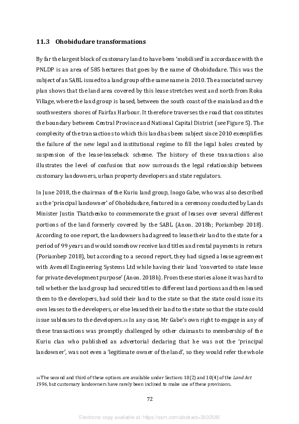
matter to the newly established Fraud and Audit Section of the Lands Department (Kep
2018).

It does seem rather odd that Mr Gabe himself would claim to be the chairman of one land
group, Kuriu, while also being the ‘principal owner’ of a large swathe of customary land
that apparently belongs to another land group, Ohobidudare. And whatever it was that
he did, or had a right to do, with the land also known as Ohobidudare, another puzzle
arises from the fact that Avenell had already started to develop part of this land area some
six years before the arrangement received the public blessing of the minister.
Construction of a 72-hectare port facility began in 2012, and this has since been followed
by construction of other commercial and residential facilities in what the company calls
the ‘Ravuvu Business Park’, which is part of what the PNLDP called the ‘Napa Napa Town
Centre’. By the end of 2018, satellite imagery shows that the land cleared for these
facilities was roughly 20 per cent of the area covered by the original SABL (see Figure 5).
It is hard to imagine that all this would have happened in the absence of some form of
legal transaction.

From notices published in the National Gazette we discover that the Ohobidudare land
group applied for incorporation in 2001, while the Kuriu group was the subject of three
different application notices gazetted under the old legal regime — in 2002, 2007 and
2009. The repetition of these notices might signal the existence of disputes about the
membership or leadership of the Kuriu group, or even the presence of two or three
groups in Roku Village that happen to have adopted the same name. A group with this
name was reincorporated in 2015, but the Ohobidudare group has not been the subject
of an application or recognition notice since the new legal regime came into effect.
Nevertheless, like the Busulum group in Lae District, it did manage to produce two survey
notices covering three land portions, still bearing the group’s name, with a combined area
of just over 130 hectares, back in 2012. As previously noted, this took place at a time
when the new legal regime was still at an experimental stage, and when survey notices
did not lead to acceptance or land title notices.

According to one of my informants, Ohobidudare and Kuriu are alternative names for the
same land group, Kuriu being the group’s real name, while Ohobidudare is the name of its
territory (Brian Aldrich, personal communication, October 2019). That would help


                                               73


                 Electronic copy available at: https://ssrn.com/abstract=3502585
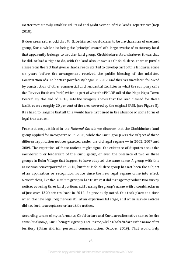
explain Mr Gabe’s claim to represent both entities, although it does not explain why the
group sought to register its existence on no less than four separate occasions between
2001 and 2009. Nor does it explain how the land in question came to be subdivided and
partially developed between 2012 and 2018 despite local challenges to Mr Gabe’s
authority.31

To the best of my knowledge, the property development story began in 2011, when Mr
Gabe and his associates tried to obtain a number of new SABLs over relatively small
portions of land within the area covered by the original SABL and then to ‘sell’ these
blocks to an Avenell subsidiary. This plan quickly came unstuck when the lease-leaseback
scheme was suspended, and would in any case have violated the provision of the Land
Act which says that the holders of SABLs can only sublease the land, not sell it. That is
why the group’s leaders decided to explore the option of securing registered group titles
under the new legal regime, this time with a view to issuing leases to the developers.
However, it then became apparent that such leases would not be ‘bankable’, and that was
when the landowners and developers came to agree that the best available option would
be for the landowners to sell their land to the state so that the developers could obtain
the state leases that are now regarded as the only secure form of title over what was
formerly customary land. I am not privy to the details of the actual agreement, but it is
based on the establishment of several corporate bodies that have been registered with
the Investment Promotion Authority.

Ohobidudare Property Development Ltd was registered in 2010 as a joint venture
between Avenell, one of its subsidiary companies and the Ohobidudare land group.
Between 2013 and 2017 its board of directors included two Avenell representatives,
Inogo Gabe and Pius Pundi. Mr Pundi is reported to have married a woman from Roku
Village who is presumably a member of the same clan as Mr Gabe (RNZ 2014). The two
Avenell directors left the board in 2017, and this company does not seem to be party to
the latest contractual arrangements. Ohobiduduare (sic) Holdings Ltd was registered in
2011. This is clearly a landowner company, with Mr Gabe, Mr Pundi, Mrs Pundi and Rei


31 By one account, a local land court magistrate supported one such challenge in 2014 when he ruled that

Ohobiduduare (sic) was the name of a gravel pit within the area covered by the SABL, and this was the
only part of the area to which Gabe held customary rights, while the rest was owned by other members of
the Kuriu clan (Samar 2014).


                                                   74


                   Electronic copy available at: https://ssrn.com/abstract=3502585
Gomara as its four shareholders. In 2015 it entered into a joint venture with an Avenell
subsidiary and another property development company called APAC Investments PNG
Ltd. Since the joint venture was registered as OPD Ltd, it appears to be the successor to
the aforementioned Ohobidudare Property Development Ltd. It still has two Avenell
representatives on its board of directors, along with Mr Gabe and Mr Pundi. Finally, in
2017, Mr Gabe registered an entity called Kuriu Ohobiduduare Foundation Ltd, in which
he is the sole shareholder, while the board of directors contains the four shareholders in
Ohobiduduare Holdings Ltd.

It may reasonably be inferred that the joint venture company OPD is the entity that will
end up with one or more state leases over the area covered by the original SABL that was
issued to the Ohobidudare land group, while the foundation has been established to
invest or distribute the benefits that the local landowners are due to receive from the
alienation of their land. It seems that the state leases have yet to be gazetted because
officials in the Lands Department have been dragging their feet or sitting on their hands
(Brian Aldrich, personal communication, October 2019). However, the contractual
arrangements between the landowners and the developers have been sufficiently robust
to allow for the development that has taken place on the part of the original SABL that is
located in National Capital District and is therefore covered by the PNLDP.

12.    Discussion and conclusion

The most recent of the national government’s medium-term (five-year) development
plans aims to raise the proportion of ‘bankable land’ in the ‘formal market’ from less than
5 per cent in 2016 to 20 per cent in 2022 (GPNG 2018: 25–6). It is not clear how the
Department of National Planning arrived at its estimate of how much land was ‘bankable’
in 2016, but it presumably consists of a combination of land that was alienated during the
colonial period and the area covered by SABLs that had not already been revoked by
judicial or executive orders. By the end of 2016, the total area covered by land titles issued
to land groups under the new legal regime was just over 100,000 hectares, about 0.2 per
cent of PNG’s total land area, so that was not a significant part of the equation. If
government officials still believe that the voluntary registration of land group titles is the
means by which their medium-term target will be met, then they are clearly deluding
themselves. The area covered by registered group titles has been growing at an average


                                               75


                 Electronic copy available at: https://ssrn.com/abstract=3502585
of less than 40,000 hectares a year since 2013 (see Table 3), and less than 60,000 hectares
were added to this area in 2018.

In any case, the ‘bankability’ of land titles granted to customary groups has turned out to
be another illusion because the banks have refused to accept them as security for loans
to the groups that hold them, despite entreaties from the lands minister (Vari 2018). This
is hardly surprising, since the banks would not be able to acquire the titles in the event of
a default, but could only attempt to recoup the money through some leasing arrangement
that might not be acceptable to members of the land group. In the absence of any sort of
government guarantee, the only alternative has been for the land group representatives
to enter into a joint venture with their ‘development partners’ in which the latter assume
responsibility for financing the enterprise, and the land group members are left to
bemoan the fact that they are ‘spectators on their own land’. This barely differs from the
sort of arrangements that were made under the terms of the lease-leaseback scheme.
Participants in the latest land summit saw this as a problem that will have to be solved if
the registration of group titles is to serve the purpose of empowering local landowners,
but they do not seem to have thought of a solution.

This is one of several problems that were identified by the National Land Development
Taskforce, established in the wake of the previous land summit in 2005, as problems that
could not be resolved by legislation alone (GPNG 2007: 114). Defenders of the legislation
that was passed in 2009 would say that its perceived failure to bring about the
‘mobilisation’ of large areas of customary land is not the result of its design but of the
government’s failure to implement most of the other recommendations made by the
taskforce (Lawrence Kalinoe, personal communication, July 2013). Recognition of the
need to pursue a range of additional reforms to the institutions responsible for land
administration and the settlement of land disputes prompted the design of a National
Land Development Program whose first phase was to be implemented over a five-year
period from 2011 to 2015 (GPNG 2010). This was to be implemented by representatives
of several different government agencies, including the Lands Department, who were to
take advice from private sector and civil society representatives, including the president
of the PNG Bankers’ Association. However, the adverse findings of the Commission of
Inquiry into SABLs seem to have reduced the willingness of Lands Department officials
to collaborate in such a wide-ranging program of institutional reform.

                                               76


                 Electronic copy available at: https://ssrn.com/abstract=3502585
Commissioner Mirou actually recommended that administration of the process of
voluntary customary land registration should be taken away from the Lands Department
and vested in a separate statutory body (Mirou 2013: 23). In its own response to the
commission’s findings, the National Executive Council resolved to transfer
administration of the land group incorporation process back to the Investment
Promotion Authority, formerly the Registrar of Companies, from which it had been
removed in 1992. Two years later, in 2016, it resolved to establish a Customary Land
Authority by 2019 but then rescinded its decision in the face of bureaucratic resistance
(Duncan 2018: 5). One provincial governor was still canvassing this option in 2018 (Elapa
2018), but in the meantime, the process of institutional reform had largely ground to a
halt (Duncan 2018). That is why the lands minister was persuaded to convene another
land summit where the option was canvassed once again.

The anomalies and inconsistencies that are evident in the notices published in the
National Gazette do suggest that Lands Department officials have struggled to abide by
the letter of the new legislation. It is difficult to say whether this counts as evidence of
corruption, incompetence, political interference, a lack of resources, or a combination of
all these things. Successive lands ministers have made public vows to improve the
department’s performance, but the repetition of such promises suggests that they are not
easily kept. If the laws have not been followed, one has to wonder if the stated aim of
eliminating ‘bogus’ land groups has been achieved in practice, and if it has not, one must
also wonder if groups of ‘paper landowners’ have managed to get their hands on titles to
land that is not really theirs. It is reassuring to know that departmental officials were able
to block the incorporation of four bogus groups over the course of six years, and also to
whittle down the size of some land claims before titles were awarded. Nevertheless, there
are still grounds to suspect the authenticity of some of the 64 groups that had been the
subject of land title notices by the end of 2018. For example, one title was awarded to a
land group called Iduhu Iduhu in one of the Motuan villages in Central Province, and ‘Clan
Clan’ is surely a rather odd name for an authentic clan. That title only covered
2.3 hectares, but we have seen that a title over almost 12,000 hectares has been awarded
to the Pairi group in Gulf Province, and a title over almost 40,000 hectares to the
mysterious Lokang group in West New Britain — a record that remained unbroken until


                                               77


                 Electronic copy available at: https://ssrn.com/abstract=3502585
the Kofega group in Central Province was awarded a title over more than 43,000 hectares
in March 2019.

It seems surprising, in retrospect, that the architects of the new legislation did not impose
some legal limit on the size of the land portions that groups could claim as their exclusive
property, given the ideal model of customary land tenure that they adopted (see
Figure 2). Of course, one would expect the size of customary group territories to vary with
population density, and groups in thinly populated areas may well have reasonable
claims over very large areas. However, the Chevron experience has shown that large
groups, or groups purporting to own large areas of land, may have very little in the way
of internal solidarity, and what they do have may be lost when their land becomes the site
of a major development project (Weiner 1998, 2007). The evidence indicates that this is
as much — if not more — of a problem in urban and peri-urban areas as it is in remote
rural areas where villagers are confronted with resource development projects. And if
land titles are awarded to groups that proceed to disintegrate, or were never integrated
in the first place, the legal indefeasibility of the titles entails a risk that some people will
lose their customary land rights altogether.

Whatever procedural irregularities might be discovered in the operation of the new legal
regime, a further process of legal and institutional reform needs to take account of the
different reasons why some people have been taking some steps towards the acquisition
of group titles, many people have only got as far as the registration of their group
identities, and an even larger number who went through the incorporation process under
the old legal regime have not bothered or been led to get their old groups reincorporated.
The evidence presented in this paper shows that there are several different answers to
these questions, yet there is not enough evidence to weigh their relative significance.

The complexity of the new legal regime must be part of the reason why people have not
taken full advantage of its provisions. The cost of producing all the evidence required by
the new incorporation process is already substantial, especially for poor rural villagers,
and the cost of producing the additional evidence required for the registration of land
titles is even greater. Some politicians and government agencies have tried to provide
financial or logistical support, as well as public exhortations, for their constituents or
clients to gather such evidence, but such efforts are not well documented and seem to be


                                                78


                  Electronic copy available at: https://ssrn.com/abstract=3502585

grossly inadequate. This could be one of the factors that drives people into the arms of
private ‘development partners’ whose main aim is to make a profit from their own access
to customary land (Roberts 2019). However, some developers do not need to bear this
cost to get the sort of access that they want. Mining companies can obtain exploration and
development licences by securing the consent of landowner representatives or ‘agents’
recognised under the terms of the Land Act, and the developers of agro-forestry projects
have found that they can get FCAs in much the same way.

In some respects, the political pressure to ‘mobilise’ customary land by means of the new
legal regime has only served to divert attention from a question that is not answered by
the new legislation, but was posed again by the 2019 land summit. That is the question of
how to secure the most equitable benefit-sharing agreements between customary
landowners and the people wanting to use their land — whether it be private companies,
government agencies, or migrant families from other parts of the country. In the
extractive industry sectors, this question is partly answered by the legal requirement for
such agreements to be produced by ‘development forums’ held before development
licences are granted (Filer 2008). In the forestry sector, it is partly answered by the legal
requirement for FMAs to precede the grant of selective logging concessions. In these
sectors, it is recognised that the institutions have not exactly solved the problem (Bird et
al. 2007; Filer 2008, 2012b, 2019). But in other sectors, including the agricultural sector,
the institutions have an even more tenuous existence (Jones and McGavin 2000; Oliver
2001). It is not clear how the amendments now made to the Land Registration Act will
lead land group managers to negotiate better agreements with developers or investors
simply because they have registered land titles.

Aside from the legal requirements of the Forestry Act and the Oil and Gas Act, there is no
inherent need for land groups to be incorporated, or for group titles to be registered, in
order for landowner representatives to negotiate benefit-sharing agreements. This point
is most clearly revealed when the agreements cover areas of land that were alienated
during the colonial period, or the few cases in which the national government has since
exercised its power of compulsory acquisition (Manning and Hughes 2008). The case of
the Lae Port Tidal Basin Project shows that a process of land group incorporation may be
quite irrelevant to such negotiations if the customary landowners already have other
types of representative institution. Even when the land in question is still customary land,

                                               79


                 Electronic copy available at: https://ssrn.com/abstract=3502585

the experience of the extractive industry sectors would not lead us to conclude that land
groups need to be incorporated before local landowner companies can benefit from
contracts with external investors.

However, ‘landowner companies’ are strange beasts that come in many shapes and sizes.
The Companies Act of 1997 does not recognise them as a distinctive type of company, so
there is no legal requirement for them to have land groups as their shareholders, despite
the fact that some of them do so, and despite the existence of longstanding
recommendations for such a requirement to be introduced as a mechanism of
accountability (Whimp 1995; Power 1995). One of the main findings of a previous
commission of inquiry into corruption in the forestry sector was that landowner
company directors engaged in ‘private dealings’ with foreign logging companies were
most unlikely to serve the interests of the customary landowners whom they claimed to
represent (Barnett 1992). That is why the Forestry Act of 1991 sought to exclude them
from the negotiation of FMAs. But the Commission of Inquiry into SABLs found that they
had regained their capacity to betray these interests through the negotiation of bad
agreements with the developers of so-called agro-forestry projects (Mirou 2013; Numapo
2013). The evidence presented in this paper suggests that they have sustained this
capacity in the negotiation of FCAs that are not based on SABLs, regardless of whether a
process of land group incorporation has been used as evidence of landowner consent to
the agreements being negotiated.

Given the wildly ambitious target expressed in the government’s medium-term
development plan, this leads us back to a pair of questions about the mobilisation of
customary land in rural areas for what PNG’s political leaders like to call ‘impact projects’,
‘economic corridors’, or ‘special economic zones’. The first is a question that was posed
by the 2019 land summit, which is what should now be done with the sections of the Land
Act that allow for the grant of SABLs. The second is a question that was not posed by the
land summit, which is what should now be done with the sections of the Forestry Act that
allow for the grant of FCAs.

In his report to the Prime Minister and National Executive Council, Chief Commissioner
John Numapo was in two minds about the retention of the lease-leaseback scheme.
Having initially said that it should be abolished, at least in its current form (Numapo


                                               80


                 Electronic copy available at: https://ssrn.com/abstract=3502585
2013: 4), he then went on to say that it should be retained (ibid.: 255). In explanation of
this discrepancy, he later wrote that it should ‘continue for large-scale, high-impact,
intensive land-based development’ (Filer and Numapo 2017: 264), apparently because
he could already see that the voluntary registration of land group titles would not serve
to mobilise areas of sufficient size to meet the government’s objectives. The National
Executive Council was less equivocal in its response to his original report. In 2014, it
resolved to repeal the relevant sections of the Land Act because the amendments made
to the Land Registration Act had made them redundant. But the relevant public servants
managed to restore the state of uncertainty by failing to produce the required
amendments to the Land Act, even though the Lands Department has followed the
executive order to suspend the operation of the whole scheme.

The situation now is that roughly half of the area covered by SABLs in 2011 is still covered
by leases that have not been revoked, but only a small fraction of the land groups that
agreed to these leases have been reincorporated under the new legal regime. The rest of
the area covered by SABLs in 2011 could technically still count as ‘public land’ because
the head leases have not been revoked, but an even smaller fraction of the land groups
that supposedly issued the head leases to the state have been reincorporated under the
new legal regime. The government seems to have no plan, let alone the institutional
capacity, to rectify this situation, either by helping the land groups to reincorporate
themselves or creating new sticks or carrots that would place this obligation on the
private sector. In these circumstances, any attempt to ‘unsuspend’ the lease-leaseback
scheme, with or without amendments to the relevant sections of the Land Act, would
almost certainly be met with concerted opposition from elements of the ‘land grab policy
network’ that persuaded the government to establish the commission of inquiry (Filer
2017).

In theory, the government could avoid the cumbersome circularity of the lease-leaseback
scheme by making provision for land management agreements, rather like FMAs, in
which land groups agree to lease their land to a government agency on condition that this
agency itself then assumes responsibility for subleasing the land to a private investor or
another government agency. Indeed, Section 10 of the Land Act already allows for this
kind of arrangement. However, the experience of forest policy reform in the 1990s should
serve as a reminder that such innovations are unlikely to achieve significant results

                                               81


                 Electronic copy available at: https://ssrn.com/abstract=3502585
unless they have the backing of foreign aid agencies or international financial institutions
such as the World Bank, and then they may not be sustainable (Filer 2000). Furthermore,
the failure of attempts at land policy reform in the 1990s should serve as a reminder that
foreign intervention in this policy space is also likely to be thwarted by political
opposition (Lakau 1997; Levantis and Yala 2008).

The question not posed by the 2019 land summit is one to which there may be an easier
answer. By the end of 2018, about 600,000 hectares of customary land had been covered
by FCAs that were still valid and had been granted by the National Forest Board without
the prior grant of SABLs by the Lands Department. This was almost as big as the area in
which currently valid FCAs had been granted after the grant of SABLs that had not since
been revoked, and it will soon get bigger. This is because the suspension of the lease-
leaseback scheme has done nothing to diminish the ability of the agro-foresters to
persuade relevant government agencies to authorise their proposals. It is not clear
whether the National Planning Department regards these forest conversion concessions
as ‘bankable land’, but it is clear that FCAs, unlike SABLs, can be legally granted directly
to foreign investors. As we have seen, the appearance of landowner consent to this
particular way of ‘mobilising’ customary land can be manufactured in several different
ways, some of which do not require a process of land group incorporation, so it is not
entirely clear why some proponents support this process and others do not. 32 The
Forestry Act could be amended to make this process mandatory, but this should be
accompanied by other measures that would force the public disclosure of the
development proposals authorised by the grant of FCAs and ensure that these are not
granted in the absence of a reasonable benefit-sharing agreement.

Political enthusiasm for ‘impact projects’ in rural areas has been partly motivated by a
desire to slow down the process of urbanisation and hence to limit the incidence of social
conflict arising from the informal sale of customary land in urban and peri-urban areas.
It is this second phenomenon that has been the primary concern of many of the advocates
of land policy reform, including those who were active participants in the latest land


32 There may be a growing incentive for the project proponents to cut corners because political support

for the implementation of ‘impact projects’ in the agricultural sector has been accompanied by continual
threats to impose a moratorium on the export of raw logs, which would not be good for the agro-forestry
business model unless the holders of FCAs are given a special exemption.


                                                   82


                    Electronic copy available at: https://ssrn.com/abstract=3502585
summit (Chand and Yala 2008, 2012). These transactions are problematic for several
reasons. Not only do they pose the risk of conflict between members of the same
customary group; they also risk a wider conflict between groups of sellers and groups of
buyers who may have very different ideas about what constitutes an informal ‘sale’ as
opposed to an informal ‘lease’ (Koczberski et al. 2009; Numbasa and Koczberski 2012).
In some circumstances, the buyers or tenants cannot be sure that what they have
purchased or rented is in fact customary land, and if it is, whether it has not already been
informally sold or leased to someone else (Chand and Yala 2008; Rooney 2017). In the
absence of legal contracts, the buyers or tenants are unable to secure bank loans for
building purposes, but they also have an incentive to invest in the bribery of government
officials in order to obtain the land titles to which they are not entitled.

The net result of all this uncertainty has been a simultaneous rise in the number of court
cases relating to such matters, in the cost of accommodation in urban areas, and in the
size of ‘haphazard informal settlements’, as well as the volume of calls for urban land
groups to register their collective land titles. If this helps to explain why groups based in
urban and peri-urban areas account for a growing proportion of the land title notices
published in the National Gazette, it does not explain why the number of notices is still
relatively small. If the notices are a true reflection of what the Lands Department has been
doing, its officials might not have been capable of doing enough to meet the demand for
registration. Alternatively, national politicians and local community leaders might not
have been able to persuade their fellow citizens that this constitutes the best solution to
the problem of urban land shortage or housing affordability.

Participants in the 2019 land summit were so concerned by the size of this problem that
they recommended a review of the possible ‘relevance’ of the Land (Tenure Conversion)
Act of 1963, which enables customary groups to transform their land into a collection of
registered freehold titles and distribute these among their individual members. This
piece of legislation is administered by the Land Titles Commission, not the Lands
Department, but the National Land Development Taskforce observed that the
commission had already lost what little capacity it once had to process applications for
conversion and recommended that the Act be repealed (GPNG 2007: 14, 94).


                                               83


                 Electronic copy available at: https://ssrn.com/abstract=3502585

The question posed by the apparent contradiction between these two recommendations
is not just a question of bureaucratic capacity. It is also a question about the relationship
between the registration of collective land rights and the maintenance of customary
social institutions. People who bemoan the inability of urban land group managers to
prevent their members from alienating their birthright to outsiders are inclined to regard
this as evidence of the breakdown of customary forms of social solidarity — a process
that has naturally gone further in urban than in rural areas. But if the transformation of
‘clans’ into miniature landowning corporations is itself inconsistent with customary ways
of making decisions about land use, even in rural areas, then the circle that cannot be
squared is the incompatibility of customary social institutions with the operation of a
capitalist economy that includes a land market.


                                               84


                 Electronic copy available at: https://ssrn.com/abstract=3502585
13.    References

Anon., 2004. ‘Wafi Landowner Group Wins Dispute over Land.’ The National, 25 August.

Anon., 2005a. ‘Landowners Receive Title to Wafi Gold/Copper Mine.’ Post-Courier,
5 April.

Anon., 2005b. ‘Wafi Owners Win Fight for Land of Gold.’ The National, 27 September.

Anon., 2008a. ‘Lae Port Work under Threat.’ Post-Courier, 19 November.

Anon., 2008b. ‘No Hiccup for Lae Port Project: IPBC.’ Post-Courier, 20 November.

Anon., 2011. ‘Tell Us Who You Are?’ Post-Courier, 19 April.

Anon., 2013. ‘Landowner Warns Settlers to Behave.’ The National, 4 December.

Anon., 2014a. ‘City LOs Call for Spin-Off Activities.’ Post-Courier, 11 December.

Anon., 2014b. ‘Village Clan Partners in Wharf Deal.’ The National, 6 August.

Anon., 2014c. ‘Lak Kandas Oil Palm Project Forum Report.’ Unpublished record of public
forum held 20 August 2014.

Anon., 2014d. ‘Central Clan Not Happy with ILG Certificate Acquisition.’ Post-Courier,
8 August.

Anon., 2015a. ‘Lands Officer Warns against Selling Land Cheaply.’ The National,
29 September.

Anon., 2015b. ‘Govt Urged to Contract Local Firms.’ The National, 17 September.

Anon., 2015c. ‘Baruni Land Group Wants Recognition.’ Post-Courier, 8 May.

Anon., 2015d. ‘Motukea Island LOs Want Govt Recognition.’ Post-Courier, 3 June.

Anon., 2015e. ‘Clan Backs City Port Project.’ Post-Courier, 3 June.

Anon., 2015f. ‘Land Group Keen to Work with Developers.’ The National, 20 August.

Anon., 2016a. ‘Locals Get ILG Papers.’ The National, 25 August.

Anon., 2016b. ‘Dialogue with Developer is Important.’ Post-Courier, 20 July.

Anon., 2016c. ‘Landowner “Participation Vital”.’ The National, 11 January.

Anon., 2018a. ‘Parliament Extends Land Group Registration.’ Post-Courier,
22 November.

Anon., 2018b. ‘Momase Heads ILGs Tally throughout Country.’ Post-Courier,
14 September.


                                               85


                 Electronic copy available at: https://ssrn.com/abstract=3502585
Anon., 2018c. ‘Industrial Development Vital: MP.’ The National, 24 April.

Anon., 2018d. ‘Clans Unite to Ensure Landowners Benefit from Lae Port.’ The National,
4 January.

Anon., 2018e. ‘Govt Told to Speed up Establishment of Authority.’ The National,
22 August.

Anon., 2018f. ‘Landowners Told Not to Sell Land.’ The National, 14 September.

Anon., 2018g. ‘Clan Demands Benefits from Port Operators.’ Post-Courier, 24 May.

Anon., 2018h. ‘Landowners Score Winning Deal.’ The National, 14 June.

Anon., 2019. ‘Forestry Project OK to Go: Governor.’ Post-Courier, 20 November.

Antonio, W., M. Wagi and L. Kari, 2010. ‘Incorporated Land Groups.’ In C. Yala (ed.), The
Genesis of the Papua New Guinea Land Reform Program: Selected Papers from the 2005
National Land Summit, pp. 61–67. Boroko: National Research Institute (Monograph 42).

Apina, A., 2012. ‘ENB Firm Plants Palms.’ The National, 30 October.

Avediba, A., 2015. ‘LOs Irked by Lack of Involvement in Project.’ Post-Courier, 9 January.

Bailey, J., 2016. ‘Plans for New Suburb Delayed.’ Post-Courier, 15 July.

Banige, E., 2009. ‘Villagers Dispute Lae Land Deals.’ The National, 26 January.

Barnett, T.E., 1992. ‘Legal and Administrative Problems of Forestry in Papua New
Guinea.’ In S. Henningham and R.J. May (eds), Resources, Development and Politics in the
Pacific Islands, pp. 90–118. Bathurst (NSW): Crawford House Press.

Baunke, V., 2017. ‘LOs Part Take in Development.’ The National, 10 April.

Bell, J., 2009. ‘Documenting Discontent: Struggles for Recognition in the Purari Delta of
Papua New Guinea.’ The Australian Journal of Anthropology 20(1): 28–47.

Bird, N., A. Wells, F. van Helden and R. Turia, 2007. ‘The Current Legal and Institutional
Framework of the Forest Sector in Papua New Guinea.’ London: Overseas Development
Institute (Papua New Guinea Forest Studies 2).

Bredmeyer, T., 1975. ‘The Registration of Customary Land in Papua New Guinea.’
Melanesian Law Journal 3: 267–287.

Chand, S., 2017. ‘Registration and Release of Customary-Land for Private Enterprise:
Lessons from Papua New Guinea.’ Land Use Policy 61: 413–419.

Chand, S. and C. Yala, 2008. ‘Informal Land Systems within Urban Settlements in
Honiara and Port Moresby.’ In AusAID 2008 (ed.), Making Land Work — Volume Two:
Case Studies on Customary Land and Development in the Pacific, pp. 85–105. Canberra:
AusAID.


                                               86


                 Electronic copy available at: https://ssrn.com/abstract=3502585
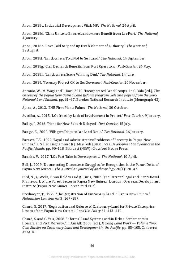
Chand, S. and C. Yala, 2012. ‘Institutions for Improving Access to Land for Settler-
Housing: Evidence from Papua New Guinea.’ Land Use Policy 29: 143–153.

CSA (Coffey Services Australia Pty Ltd), 2018. Frieda River Limited, Sepik Development
Project: Environmental Impact Statement. Abbotsford (VA): https://friedariver.com/eis/.

Duncan, R., 2018. ‘A Review of the Implementation of the National Land Development
Program in Papua New Guinea.’ Boroko: National Research Institute (Discussion
Paper 160).

Elapa, J., 2010. ‘“Urbanisation Project Sabotaged”.’ The National, 9 November.

Elapa, J., 2018. ‘Haiveta Calls for a Lands Authority.’ Post-Courier, 20 February.

Eroro, S., 2011. ‘Report Not True as Land Not Sold.’ Post-Courier, 11 March.

Filer, C., 2000. The Thin Green Line: World Bank Leverage and Forest Policy Reform in
Papua New Guinea. Port Moresby and Canberra: National Research Institute and
Australian National University.

Filer, C., 2007. ‘Local Custom and the Art of Land Group Boundary Maintenance in Papua
New Guinea.’ In J.F. Weiner and K. Glaskin (eds), Customary Land Tenure and
Registration in Australia and Papua New Guinea: Anthropological Perspectives, pp. 135–
173. Canberra: ANU E Press (Asia-Pacific Environment Monograph 3).

Filer, C., 2008. ‘Development Forum in Papua New Guinea: Upsides and Downsides.’
Journal of Energy & Natural Resources Law 26(1): 120–150.

Filer, C., 2011a. ‘New Land Grab in Papua New Guinea.’ Pacific Studies 34(2/3): 269–
294.

Filer, C., 2011b. ‘The New Land Grab in Papua New Guinea: A Case Study from New
Ireland Province.’ Canberra: Australian National University, College of Asia and the
Pacific, State Society and Governance in Melanesia Program (Discussion Paper 2011/2).

Filer, C., 2012a. ‘Why Green Grabs Don’t Work in Papua New Guinea.’ Journal of Peasant
Studies 39: 599–617.

Filer, C., 2012b. ‘The Development Forum in Papua New Guinea: Evaluating Outcomes
for Local Communities.’ In M. Langton and J. Longbottom (eds), Community, Futures,
Legal Architecture: Foundations for Indigenous Peoples in the Global Mining Boom,
pp. 147–161. Abingdon: Routledge.

Filer, C., 2017. ‘The Formation of a Land Grab Policy Network in Papua New Guinea.’ In
S. McDonnell, M.G. Allen and C. Filer (eds), Kastom, Property and Ideology: Land
Transformations in Melanesia, pp. 169–204. Canberra: ANU Press.

Filer, C., 2019. ‘Methods in the Madness: The “Landowner Problem” in the PNG LNG
Project.’ Canberra: Australian National University, Crawford School of Public Policy,
Development Policy Centre (Discussion Paper 76).


                                               87


                 Electronic copy available at: https://ssrn.com/abstract=3502585

Filer, C. and J. Numapo, 2017. ‘The Political Ramifications of Papua New Guinea’s
Commission of Inquiry.’ In S. McDonnell, M.G. Allen and C. Filer (eds), Kastom, Property
and Ideology: Land Transformations in Melanesia, pp. 251–282. Canberra: ANU Press.

Fingleton, J., 1982. ‘Land Policy in Papua New Guinea.’ In D. Weisbrot, A.H. Paliwala and
A. Sawyerr (eds), Land and Social Change in Papua New Guinea, pp. 105–125. Sydney:
Butterworths.

Fingleton, J., 2005. ‘Land, an Asset of Great Value.’ Post-Courier, 9 March.

Fingleton, J., 2007. ‘A Legal Regime for Issuing Group Titles to Customary Land: Lessons
from the East Sepik.’ In J.F. Weiner and K. Glaskin (eds), Customary Land Tenure and
Registration in Australia and Papua New Guinea: Anthropological Perspectives, pp. 15–38.
Canberra: ANU E Press (Asia-Pacific Environment Monograph 3).

FMPP (Forest Management and Planning Project), 1995. Working Papers Produced as
Part of the FMPP Landowner Involvement Component 1993 to 1995. Boroko: PNG Forest
Authority, Groome Poyry Ltd and World Bank.

Forest Trends, 2006. Logging, Legality and Livelihoods in Papua New Guinea: Synthesis of
Official Assessments of the Large-Scale Logging Industry. Jakarta: Forest Trends.

Gabriel, J., P.N. Nelson, C. Filer and M. Wood, 2017. ‘Oil Palm Development and Large-
Scale Land Acquisitions in Papua New Guinea.’ In S. McDonnell, M.G. Allen and C. Filer
(eds), Kastom, Property and Ideology: Land Transformations in Melanesia, pp. 205–250.
Canberra: ANU Press.

Gare, C., 2017. ‘Story Behind Lavongai’s Success.’ Post-Courier, 6 October.

Goldman, L., 2007. ‘Incorporating Huli: Lessons from the Hides Licence Area.’ In
J.F. Weiner and K. Glaskin (eds), Customary Land Tenure and Registration in Australia
and Papua New Guinea: Anthropological Perspectives, pp. 97–115. Canberra: ANU E
Press (Asia-Pacific Environment Monograph 3).

Goldman, L.R., 2009. Papua New Guinea Liquefied Natural Gas Project: Social Impact
Assessment 2008. Abbotsford (VA): Coffey Natural Systems Pty Ltd for Esso Highlands
Ltd (Appendix 26 of PNG LNG Project Environmental Impact Statement).

GPNG (Government of Papua New Guinea), 1973. Report of the Commission of Inquiry
into Land Matters. Port Moresby: Government Printer.

GPNG (Government of Papua New Guinea), 1993. ‘National Forestry Development
Guidelines.’ Port Moresby: PNG Forest Authority.

GPNG (Government of Papua New Guinea), 1996. ‘The National Forest Plan for Papua
New Guinea.’ Port Moresby: PNG Forest Authority.

GPNG (Government of Papua New Guinea), 2007. The National Land Development
Taskforce Report: Land Administration, Land Dispute Settlement, and Customary Land
Development. Boroko: National Research Institute (Monograph 39).


                                               88


                 Electronic copy available at: https://ssrn.com/abstract=3502585

GPNG (Government of Papua New Guinea), 2008. Review of Incorporated Land Groups
and Design of a System of Voluntary Customary Land Registration. Boroko: Constitutional
and Law Reform Commission (Report 5).

GPNG (Government of Papua New Guinea), 2010. ‘Papua New Guinea National Land
Development Program Phase 1 (2011–2015): Implementation Plan.’ Port Moresby:
National Land Development Program Management Committee.

GPNG (Government of Papua New Guinea), 2012. ‘National Forest Plan (Draft).’ Port
Moresby: PNG Forest Authority.

GPNG (Government of Papua New Guinea), 2018. ‘Medium Term Development Plan III
2018–2022.’ Port Moresby: Department of National Planning and Monitoring.

GPNG (Government of Papua New Guinea), 2019. ‘National Land Summit 2019: Issues,
Main Points and Resolutions.’ The National, 17 May.

Griffin, J.A., 2017. ‘Report of the Administrative Inquiry into the Land Transactions and
Deals Involving the Five Portions of Land by the Ministry of Defence and the Ministry of
Public Enterprises and State Investments.’ Waigani: Report to the PNG Prime Minister
and National Executive Council.

Hakalits, S., 2015. ‘Oil Palm Project Landowners to Get Certificates.’ Post-Courier,
14 January.

Hambloch, C., 2018. ‘Land Formalization Turned Land Rush: The Case of the Palm Oil
Industry in Papua New Guinea.’ Paper prepared for presentation to the World Bank
conference on ‘Land and Poverty’, Washington (DC), 19–23 March.

HIL (Hakau Investments Ltd), 2011. ‘Torokina Oil Palm Development Project: Rapid
Rural Appraisal Report.’ Unpublished report to the Autonomous Bougainville
Government.

HIL (Hakau Investments Ltd), 2012. ‘Torokina Oil Palm Development Project: Clan Land
Incorporation and Registration Report.’ Unpublished report to the Autonomous
Bougainville Government.

HIL (Hakau Investments Ltd), 2014. ‘Final Report on Torokina Oil Palm Development
Project.’ Unpublished report to the Autonomous Bougainville Government.

Hulme, D., 1983. ‘Credit, Land Registration and Development: Implications of the Lease-
Lease-Back Scheme.’ Melanesian Law Journal 11: 91–98.

Jones, L.T. and P.A. McGavin, 2000. ‘Creating Economic Incentives for Land Mobilisation
in Papua New Guinea.’ Port Moresby: Institute of National Affairs (Discussion Paper 77).

Kalebe, J., 2017. ‘Man Faces High Court Case as Police Fight Land Fraud.’ The National,
1 November.

Kama, L., 2018. ‘Tkatchenko Wants 18,000 Landowner Groups to Re-List.’ The National,
21 November.

                                               89


                 Electronic copy available at: https://ssrn.com/abstract=3502585

Kapin, F., 2016. ‘LOs Call for Govt Help on Land Battle.’ Post-Courier, 9 March.

Kapin, F., 2018. ‘Lae City Landowners Finally Get Compensated.’ Post-Courier,
27 September.

Kenneth, G., 2014. ‘Govt to Turn Ramu into Giant Food Bowl.’ Post-Courier, 4 August.

Kenneth, G., 2015. ‘Local Firm Plans K400m Palm Oil Investment.’ Post-Courier, 24 April.

Kenneth, G., 2016. ‘Landowners Serve Petition to Tomuriesa.’ Post-Courier, 28 April.

Kenneth, G., 2018. ‘Tatana LOs Claim PNGDF Negotiated with Illegitimate Group.’ Post-
Courier, 7 August.

Kep, Y., 2018. ‘Landowners Call for Investigation Conclusion.’ Post-Courier, 28 June.

Kivia, H., 2012. ‘LO Unaware of Land Deal.’ Post-Courier, 6 November.

Kivia, H., 2014. ‘MP Upset over Report That Snubs Landowners.’ Post-Courier,
18 December.

Kivia, H., 2015. ‘New Firm Joins Row over Lae Port.’ Post-Courier, 6 November.

Koczberski, G., G.N. Curry and B. Imbun, 2009. ‘Property Rights for Social Inclusion:
Migrant Strategies for Securing Land and Livelihoods in Papua New Guinea.’ Asia Pacific
Viewpoint 50(1): 29–42.

Korugl, P., 2008. ‘Court to Hear City Land Row.’ Post-Courier, 23 December.

Korugl, P., 2009. ‘Lae Land Threat.’ Post-Courier, 15 January.

Koyama, S.K., 2004. ‘Reducing Agency Problems in Incorporated Land Groups.’ Pacific
Economic Bulletin 19(1): 20–31.

Krau, D., 2005. ‘Lands Dept Recalls Title.’ The National, 13 April.

Lakau, A.A.L., 1997. ‘Customary Land Tenure, Customary Landowners and the Proposals
for Customary Land Reform in Papua New Guinea.’ Anthropological Forum 7(4): 529–547.

Lechner, A.M., J. Hunter and K.D. Ngo, 2018. ‘Desktop Assessment of Commercial
Forestry and Agroforestry within the Sepik Development Project Infrastructure
Corridor.’ Report to Frieda River Ltd (reproduced as Appendix 9 of the Sepik
Development Project Environmental Impact Statement).

Levantis, T. and C. Yala, 2008. ‘Breaking Away from the Land Policy Stalemate.’ Pacific
Economic Bulletin 23(1): 99–110.

Manning, M. and P. Hughes, 2008. ‘Acquiring Land for Public Purposes in Papua New
Guinea and Vanuatu.’ In AusAID 2008b (ed.), Making Land Work — Volume Two: Case
Studies on Customary Land and Development in the Pacific, pp. 241–263. Canberra:
AusAID.


                                               90


                 Electronic copy available at: https://ssrn.com/abstract=3502585

Masiu, R., 2019. ‘LOs Query Oil Palm Project.’ Post-Courier, 24 April.

Mirou, N., 2013. Commission of Inquiry into Special Agriculture and Business Lease (C.O.I.
SABL): Report. Port Moresby: Report to the PNG Prime Minister and National Executive
Council.

Nalu, M., 2013. ‘Hydro Plant Launched.’ The National, 4 March.

Nalu, M., 2016. ‘Oil Palm Project in Order.’ The National, 18 April.

Nanau, E., 2019a. ‘Petition Challenges Project.’ Post-Courier, 7 November.

Nanau, E., 2019b. ‘Landowners Push to Harvest Forest.’ Post-Courier, 19 November.

Nao, K., 2018a. ‘Tatana Clans Verify Deal with PNGDF and Ownership.’ Post-Courier,
15 August.

Nao, K., 2018b. ‘Tug of War Amongst Tatana Landowners Continues.’ Post-Courier,
16 August.

Nao, K., 2019. ‘Developer Rejects Stop-Work Notice.’ Post-Courier, 9 October.

Nebas, F., 2011. ‘Clans Sign MOU.’ Post-Courier, 8 April.

Nebas, F., 2014. ‘LO Alerts Public to Imposters.’ Post-Courier, 13 August.

Numapo, J., 2013. Commission of Inquiry into the Special Agriculture and Business Lease
(SABL): Final Report. Port Moresby: Report to the PNG Prime Minister and National
Executive Council.

Numbasa, G. and G. Koczberski, 2012. ‘Migration, Informal Urban Settlements and Non-
Market Land Transaction: A Case Study of Wewak, East Sepik Province, Papua New
Guinea.’ Australian Geographer 43: 143–161.

Oliver, N., 2001. ‘Lease, Lease-Back: An Instrument for Forestry?’ In C. Hunt (ed.),
Production, Privatisation and Preservation in Papua New Guinea Forestry, pp. 59–74.
London: International Institute for Environment and Development.

Pewa, J., 2014. ‘The Acting Registrar of Titles Must Fully and Completely Comply with
the SABL Commission of Inquiry Report and Recommendations.’ The National, 18 July.

Philemon, O., 2013. ‘Ahi Leaders: Control Sale of Land.’ Post-Courier, 28 February.

PNGexposed, 2016. ‘Walter Schnaubelt Set up the Whole Illegal Konoagil Logging
Operation.’ Anonymous blog post, 29 December:
https://pngexposed.wordpress.com/2016/12/29/schnaubelt-set-up-the-whole-
konoagil-illegal-logging-operation/.

PNGexposed, 2017. ‘Kanoagil: The Anatomy of an Illegal Logging Operation.’
Anonymous blog post, 5 January: https://pngexposed.wordpress.com/
2017/01/05/kanoagil-the-anatomy-of-an-illegal-logging-operation/.


                                               91


                 Electronic copy available at: https://ssrn.com/abstract=3502585

PNGFRT (PNG Forestry Review Team), 2001. ‘Middle Ramu Block 1 (Kumlam) (Madang
Province).’ Unpublished report to the Government of PNG.

PNGNC (PNG National Court), 2013. Musa Century v O’Neill and Others. Waigani:
PGNC 152, 23 August.

PNGNC (PNG National Court), 2015. Limawo Holdings and Others v Numapo and Others.
Wewak: PGNC 155, 20 August.

PNGNC (PNG National Court), 2016. Puipui and Others v Pat and Others. Kokopo:
PGNC 326, 25 August.

PNGSC (PNG Supreme Court), 2015. Tutuman Development v Growmax (PNG). Waigani:
PGSC 7, 6 February.

Poriambep, C., 2018. ‘Roku LOs sign MOA.’ Loop PNG blog post, 13 June:
http://www.looppng.com/community/roku-los-sign-moa-77360.

Power, A.P., 1995. ‘Village Guide to Land Group Incorporation.’ Wewak: Ivin Enterprises
for PNG Forest Management and Planning Project.

Power, A.P., 1996. ‘Mining and Petroleum Development under Customary Land Tenure:
The Papua New Guinea Experience.’ In D. Denoon, C. Ballard, G. Banks and P. Hancock
(eds), Mining and Mineral Resource Policy Issues in Asia-Pacific: Prospects for the 21st
Century, pp. 135–143. Canberra: Australian National University, Research School of
Pacific and Asian Studies.

Power, T., 2008. ‘Incorporated Land Groups in Papua New Guinea.’ In AusAID
(Australian Agency for International Development) (ed.), Making Land Work — Volume
Two: Case Studies on Customary Land and Development in the Pacific, pp. 3–20. Canberra:
AusAID.

Rai, F., 2007. ‘Homes to Be Built on Customary Land.’ The National, 26 April.

Rai, F., 2009. ‘Govt Warned to Obey Land Claim.’ Post-Courier, 5 January.

Rai, F., 2011. ‘Butibum Clan Disputes Signing.’ Post-Courier, 14 April.

RNZ (Radio New Zealand), 2014. ‘Impacts of Gas Project Reach New Chapter in PNG.’
Dateline Pacific, 8 May.

Roberts, J., 2019. ‘We Stay the Same’: Life, Logging, and the Continuing Pursuit of
Development on New Hanover Island (Lavongai), Papua New Guinea. San Antonio:
University of Texas (Ph.D. thesis).

Rogakila, I., 2011. ‘Affidavit Submitted to the Commission of Inquiry into Special
Agricultural and Business Leases, 24 August.’


                                               92


                 Electronic copy available at: https://ssrn.com/abstract=3502585
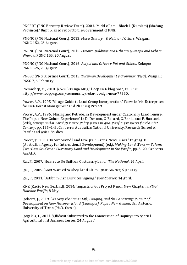
Rooney, M.N., 2017. ‘‘There’s Nothing Better than Land’: A Migrant Group’s Strategies
for Accessing Informal Settlement Land in Port Moresby.’ In S. McDonnell, M.G. Allen
and C. Filer (eds), Kastom, Property and Ideology: Land Transformations in Melanesia, pp.
111–144. Canberra: ANU Press.

Samar, J., 2014. ‘Eight companies told to cease royalty payments to illegitimate
landowners at Roku.’ Masalai blog post, 30 September:
https://masalai.wordpress.com/2014/09/30/eight-companies-told-to-cease-royalty-
payments-to-illegitimate-landowners-at-roku/.

Tammisto, T., 2016. ‘Enacting the Absent State: State-Formation on the Oil-Palm
Frontier of Pomio (Papua New Guinea).’ Paideuma 62: 51–68.

Tarawa, H., 2017a. ‘Developers Using Old Certificates Illegal: Lands.’ The National,
15 March.

Tarawa, H., 2017b. ‘Minister Wants Extension for Land Groups Registration.’ The
National, 7 September.

Tarawa, H., 2018. ‘Districts Soon to Have Agro-Forestry Industry.’ The National,
5 February.

Taylor, M. and K. Whimp, 1997. ‘Report on Land Issues and Hydrocarbon Framework
Study.’ Port Moresby: Fuels and Energy Management Group for Department of
Petroleum and Energy.

TVH (Tangoy Vivafounder Holdings Ltd), 2017. First Phase of Block One Environmental
Impact Statement: Idam Siawi Integrated Agro-Forestry Development Project, Papua New
Guinea. Unpublished report to the PNG Conservation and Environment Protection
Authority.

Vari, M., 2018. ‘“Bankable” Customary Land Vital.’ Post-Courier, 22 January.

Ward, A., 1983. ‘The Commission of Inquiry into Land Matters 1973: Choices,
Constraints and Assumptions.’ Melanesian Law Journal 11: 1–13.

Weiner, J., 1998. ‘The Incorporated Ground: The Contemporary Work of Distribution in
the Kutubu Oil Project Area.’ Canberra: Australian National University, Resource
Management in Asia-Pacific Project (Working Paper 17).

Weiner, J.F., 2007. ‘The Foi Incorporated Land Group: Group Definition and Collective
Action in the Kutubu Oil Project Area, Papua New Guinea.’ In J.F. Weiner and K. Glaskin
(eds), Customary Land Tenure and Registration in Australia and Papua New Guinea:
Anthropological Perspectives, pp. 117–134. Canberra: ANU E Press (Asia-Pacific
Environment Monograph 3).

Whimp, K., 1995. ‘Representative Resource Owner Bodies for Forestry Projects.’
Boroko: Forest Management and Planning Project.

Wille, D., 2015. ‘Rightful Land Group Opposes Ownership Claims.’ Post-Courier, 12 May.


                                               93


                 Electronic copy available at: https://ssrn.com/abstract=3502585
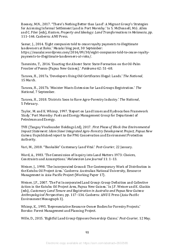
Yafoi, M., 2017. ‘K300m Project Set to Boost Industry.’ Post-Courier, 5 May.

Yala, C. (ed.), 2010. The Genesis of the Papua New Guinea Land Reform Program: Selected
Papers from the 2005 National Land Summit. Boroko: National Research Institute
(Monograph 42).


                                               94


                 Electronic copy available at: https://ssrn.com/abstract=3502585